Atmospheric river: Roads closed, streets flooded, creeks overflow across Bay Area
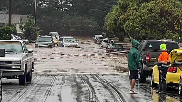
SAN FRANCISCO -- Flooding and rock slides closed portions of roads in the Bay Area as a winter storm roared ashore Saturday bringing drenching rain to a parched state as the year drew to a close.
The storm shut down two major Bay Area freeways.
Highway 101 in South San Francisco looked more like a river much of the day and remained shut into the evening. Northbound lanes were reopened around 8 p.m.
In the East Bay, Interstate 580 was also shut in San Leandro due to flooding.
Some rainfall totals in the San Francisco Bay Area topped 4 inches.
Rising waters from the San Lorenzo River in Santa Cruz County prompted officials to issue evacuation orders for Felton Grove and Paradise Park. [Check your zone at http://community.zonehaven.com]
The Monterey County Sheriff's Office issued an evacuation warning for residents in the vicinity of Santa Rita Creek Saturday afternoon.
The precautionary warning for the Bolsa Knolls neighborhood was issued due to the rising water levels in the creek, which officials expect will spill over its banks.
The warning covers areas north of Russell Road, east of Bellinzona Road, south of St Moritz Way and west of San Juan Grade and west of Paul Avenue. The warning will be in effect until further notice, according to the sheriff's office.
Officials in San Francisco issued alerts for several areas affected by mudslides and flooding Saturday.
Bernal Heights Park parking lot, 400 Block of Ulloa Street and the area of O'Shaughnessy Boulevard and Malta Drive were impacted by mudslides. Residents should expect traffic delays, consider alternate routes and allow for additional travel time.

In addition, residents are urged to avoid the areas of 14th and Folsom streets as well as Marina Boulevard by Marina Green due to flooding.
Along San Francisco's famed Fisherman's Wharf, most crab stands were closed due to flooding along that stretch of Taylor Street.
In San Mateo County, a fire crews helped pull people from flooded homes in Half Moon Bay.
At least two Sonoma County creeks overflowed their banks early Saturday morning and others were nearing flood stage.
The intense downpours from the storm will be falling on already saturated hillsides leading to excessive runoff and the threat of landslides.
Early Saturday morning, the National Weather Service issued flood warnings and flood advisories for communities across the Bay Area.
A flood warning was issued for Santa Rosa, Petaluma, Novato, Rohnert Park, Windsor, Healdsburg, Sonoma, Cloverdale, Sebastopol, Cotati, Larkfield-Wikiup, Roseland, South Santa Rosa, Boyes Hot Springs, Black Point-Green Point, Forestville, Guerneville Graton, Occidental and Monte Rio.
KPIX 5 First Alert Weather: Current Conditions, Forecasts, Alerts For Your Area
"A couple of creeks (Green Valley and Willow Brook) across Sonoma County are already above flood stage, with a couple of more (Santa Rosa and Colgan) above action stage and approaching minor flood," the weather service reported at 5:20 a.m.
There also was a wind advisory in effect with reports of some gusts as high as 60 mph over the past 12 hours.
Around midday, the National Park Service announced closures at many sites in the Golden Gate National Recreation Area including Alcatraz, Fort Point, Muir Woods, Point Bonita Lighthouse, Nike Site, Tennessee Valley Beach and the upper end of Conzelman Road overlooking the Golden Gate Bridge.
Wet conditions and flooding on roadways contributed to dozens of incidents reported on Bay Area roadways.
Shortly after 11 a.m., the San Francisco CHP office tweeted that Highway 101 was shut down in both directions due to major flooding. Drivers were advised to use I-280 as an alternate route. By 8 p.m. only the northbound lanes had reopened.
At around 10:20 a.m., Caltrans officials tweeted that Niles Canyon Road was closed in both direction at Mission Blvd. (SR-238) between Fremont and Sunol in Alameda County due to debris flow. It was unknown when the highway will re-open. Niles Canyon Road was shut down on Friday due to a slide near Palomares Rd, but this was a new incident.
Highway 1 near Big Sur was also closed due to a rockslide. The highway had just reopened about three weeks ago following another slide in the area. Caltrans is working to clear the highway but gave no estimate on when that will reopen.
There were problems reported on I-580 in the East Bay, with flooding shutting down the freeway in both directions in San Leandro at Fairmont due to roadway flooding and a rock and mudslide blocking the two right lanes of westbound I-580 in Castro Valley.
Officials reported a dozen incidents and closures in Santa Cruz County, including the closure of Highway 9 at Bear Creek due to a slide.
An accident on Hwy 242 south at Concord Avenue in the East Bay was blocking lanes. There were reports of about a foot of water in the roadway.
The Stockton police department posted photos of a flooded railroad underpass and a car that appeared stalled in more than a foot of water.
Police in Belmont reported flooding in a number of areas, including on Harbor Boulevard at Old County Road where a car was submerged in a flooded underpass. First responders had to rescue a driver from a car that got stuck in flood waters, but the person was fine.
Several roadways in San Mateo were closed Saturday morning due to flooding.
San Mateo police urged drivers to avoid the area of 42nd Avenue between El Camino Real and Pacific Boulevard, which is a Caltrain underpass, and the area of Delaware Street between Bermuda Drive and Saratoga Drive.
Bermuda Drive is also flooding due to Borel Creek overflowing, according to police.
Check South Bay creek levels for flooding
Pleasant Hill police advised people to be aware of flooding throughout the city. Residents were told to avoid the areas of Patterson Blvd. between Monte Cresta and Santa Barbara, and Astrid Dr between Pleasant Valley at the bend due to heavy flooding. Caution was also advised at freeway on and off ramps.
The downpours also created hazardous driving conditions. At 5:47 a.m. CHP officers were responding to more than 40 incidents including accidents, debris slides and roadway flooding.
The first storm earlier this week dumped nearly five inches of rain on Mt. Tamalpais and also in the Santa Cruz Mountains.
"As this Pineapple Express launches its moisture toward the Bay Area, rain rates will go up," forecasters said. "That said, the plume of highest moisture will be narrow and intense. Models have varied by numerous miles as to where the head of this stream will initially take aim. Some have it in Mendocino County, while others impact San Mateo County."
Residents in the North Bay were bracing for the worst from Saturday's storm.
Tamalpais Valley resident Becky King tells KPIX that she is worried if the drains near her home can handle the heavy rainfall.
"My house is near a creek that rises above my house level. And they try to enforce it every year, but we usually get flooding," said King. "So, this year I'm a little more concerned."
Creek levels around the county, like the one near King's home, are what the Marin County Fire Department will keep a close eye on during this storm.
"Friday and Saturday seem like the bulk of extreme weather will be, so we'll look at staffing our stations with more people," said Marin County Fire Deputy Chief Chris Martinelli. "If we see creek levels getting up higher that's what will trigger us to staff our water rescue resources."
Of even greater concern is what the next stormy week holds.
"We are in for an extended wet pattern where these saturated soils won't have time to really dry out," the weather service said. "The only break we get from rain will happen on Jan 1, but then more rain occur Jan 2-5 with a third moderate atmospheric river moving into our region around Jan 4-5."
"At this time, the rain totals look to be similar or a little higher than what we saw on Dec 26-27 and what we may see Saturday. Expect several more inches. After Jan 5, it seems light to moderate rain could persist into the second week of January. If that's the case, then residents across the Bay Area and Central CA need to be aware that additional flooding and shallow mudslides could occur."
Avalanche warnings were issued in the backcountry around Lake Tahoe and Mammoth Lakes south of Yosemite.
On the Sierra's eastern front, flood watches and warnings were issued into the weekend north and south of Reno where minor to moderate flooding was forecast along some rivers and streams.
In Southern California, moderate-to-heavy rain was falling Saturday. The region will begin drying out on New Year's Day, with no rainfall expected during Monday's Rose Parade in Pasadena.


