LNU Lightning Complex Update: Homes Burn Near Healdsburg; 3 Napa Victims Found In Fire-Ravaged Neighborhood
HEALDSBURG (CBS SF) -- The deadly LNU Lightning Complex of wildfires grew to 302,388 acres in Sonoma, Solano and Napa counties by Friday evening, burning homes west of Healdsburg overnight and forcing new evacuations in the Forestville and Lake Sonoma areas
Cal Fire issued an order for the following new areas as the Walbridge Fire -- along with the Hennessey Fire, the largest blazes in the complex -- advanced further into Sonoma County.
- All areas south of River Rd. from Martinelli Rd. to the intersection of River Rd at Trenton Rd.
- West of Covey Rd.
- North of Front St. / Hwy. 116
- East of Martinelli Rd.
- North of Stewarts Point Skaggs Springs Road to the eastern edge of Lake Sonoma
- Everything west of the eastern edge of Lake Sonoma to the western boundary that runs north along the ridge line from the intersection of Stewarts Point Skaggs Springs Rd @ Old Stewarts Point Skaggs Springs Road to the interception of Rockpile Road @ Cooley Ranch Road north to the Mendocino County Line.
Four people have already lost their lives in the complex of fires that were ignited by dry lightning strikes on Monday. Three of those fatalities were in Napa County and the fourth in Solano County, where a wall of flames destroyed homes along a stretch of Pleasants Valley Road on Wednesday.
Napa County Sheriff's Office spokesman Henry Wofford said the bodies were recovered from the home in the 6900 block of Hwy. 128 on Thursday. The fire was believed to be the cause of death.
The home was in a heavily wooded, rural section of Napa County with "hundreds and hundreds of trees and steep terrain," Wofford said. "It's a place that could catch fire very quickly."
The structure had no foundation and appeared to be a manufactured home.
"I don't know how many homes in that area burned but I drove through there today and it is entirely devastated," he added. "There were a lot of homes burned."
"They seemed like good people," said Hirday Dhillon, who lives about a quarter mile away. "My condolences, you know. It's a tragedy."
Dhillon evacuated on Tuesday night and just returned Friday afternoon to find his house still standing but his detached garage and his prize antique cars were destroyed.
Another four people have suffered injuries as the complex of fires, stretching from the shores of Lake Berrysessa to Fairfield in the east, has destroyed 480 structures, damaged 125 and threatened 30,500 more by Friday morning.
The blaze has grown into the 10th largest wildfire in the state history, according to Gov. Gavin Newsom.
"The challenge we are facing, the fire concentration facing us here in the state, is now disproportionately impacting Northern California," the governor said at a morning news conference. "And that is because of close to 12,000 lightning strikes that we experience over a 72-hour period."
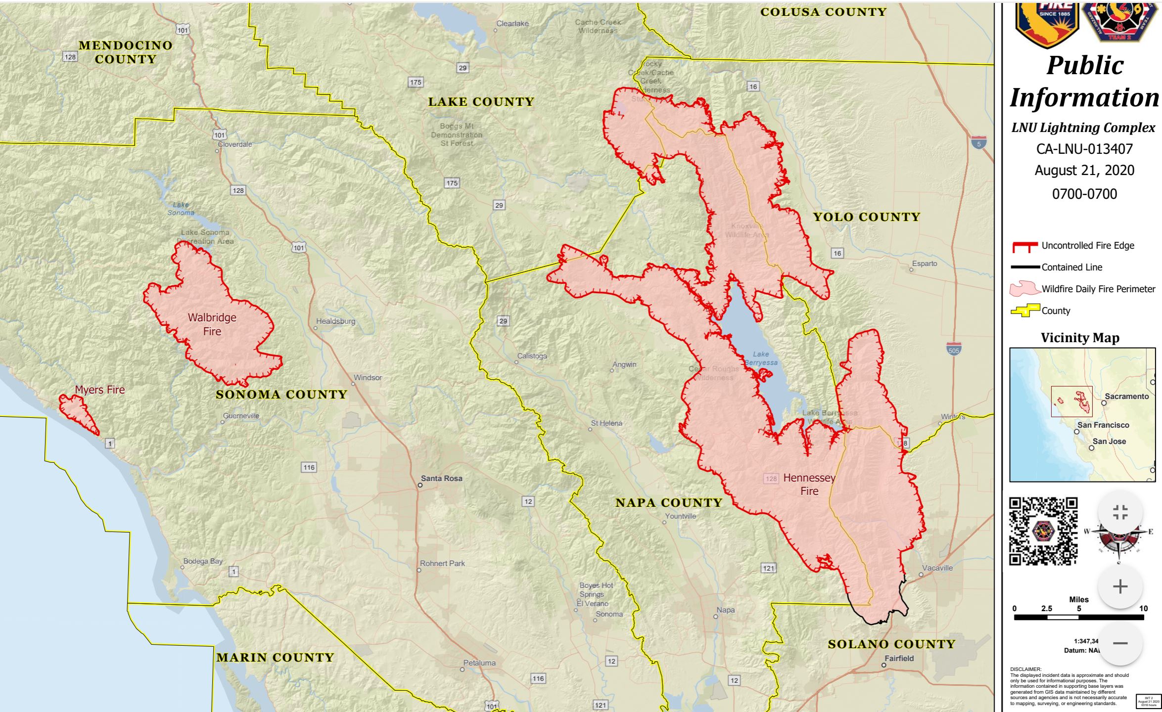
To make matters easier logistically, Cal Fire broke the LNU Complex into two sections -- East and West -- on Friday. To the West was the Hennessey fire and the seven smaller wildfires that have merged into it. The fires in this section have burned at 256,102 acres and were 7 percent contained.
The East was composed of the Walbridge and Meyers fires. The Walbridge fire had grown to a 21,125 acres with zero containment. The Meyers Fire was at 3,000 acres with zero containment.
"We are having some evacuation orders lifted but along with that -- this is interesting though -- we are also in the process of adding more evacuations. That is something we normally don't see," said incident commander Cal Fire Chief Sean Kavanaugh. "We are spread out on a such a large geographical are that we have different fire behavior, different levels of containment."
Evacuation orders were lifted Friday for the portion of Silverado Trail between Rosedale Road and Highway 29 near Calistoga.
Reinforcements arrived overnight, doubling the number of firefighters on the lines to over than 1,000. Still, Cal Fire officials warned that "significant fire growth is expected."
"Extreme fire behavior with short and long range spotting are continuing to challenge firefighting efforts," officials said. "Fires continue to make runs in multiple directions and impacting multiple communities. "
One source of concern for firefighters were the blazes around Lake Berrysessa where "multiple fires have merged on the north side of
(the lake) into the Hennessey Fire and continue to actively burn with critical spreads and is moving into large areas of timber."
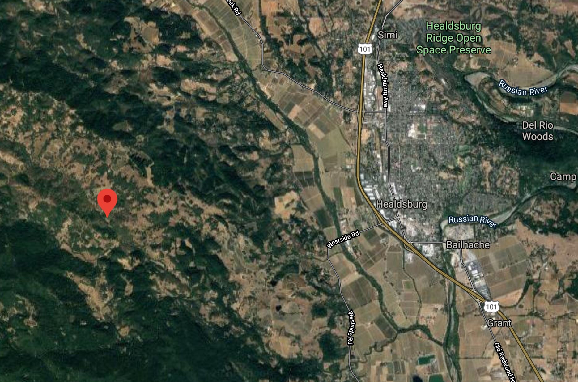
Another was west of Healdsburg where overnight, the out-of-control Walbridge Fire, roared down Wallace Creek Road, burning several homes and sending residents fleeing for safety.
The area was initially under an evacuation warning, but overnight winds accelerated the advancing wall of flames toward the wooded, hilly area 12 miles west of Healbsburg.
Video shot around 2 a.m. as the fire rolled through showed homes consumed by flames, power poles, vegetation and trees ablaze.
Many residents in living west of Healdsburg hurriedly evacuated whatever they could carry from their homes Thursday night, as the flames closed in.
Roads in the Mill Creek area became impassable as a raging fire scorched the mountainside. Flames were seen shooting up the sides of the majestic redwoods, burning wildly out of control.
Jason Passalacqua, who lives off Mill Creek Road said, "It's scary at the end of the day and it's out of anybody's control."
Passalacqua has been working all day and night on what he can control. "We trimmed back trees, put sprinklers on the roof and, most importantly, I have friends that have showed up that have offered to help."
Lake County
Evacuation Order:
- Hidden Valley Lake and Jerusalem Valley areas, including residents living North of Butts Canyon Road, South of Hofacker Ln to Morgan Valley Rd, East of Hwy. 29 and West of the Lake/Napa County line.
A temporary evacuation point has been set up at the old airstrip off of Hwy. 53 in Clearlake.
- Eastside of Highway 29 – North of the Napa/Lake County line up to the southern Intersection of Highway 29 / St Helena Creek Rd (Across from the Twin Pine Casino)
- All of St Helena Creek Rd - to the Highway 29 / St Helena Creek Rd / Butts Canyon Intersection
- All areas and residents North and South of Morgan Valley Road (north of the previously established evacuation line (from SF-29 and Hofacker Lane to Morgan Valley Road)
- East of Sky High Ridge Road, South of SR-20 and west of the Lake County line.
Evacuation Warning:
- All areas west of Highway 29 (including areas west of Saint Helena Creek Rd.)
- North and East of the Lake/Napa County Line (extending north to the Anderson Springs Rd. continuing between the County Line and Highway 175)
- South of Anderson Springs Rd, Neft Rd., and the Boggs Mountain Demonstration State Park Area prolongation to the intersection of Hofacker Ln. and SR-29 - This includes Middletown proper
- All areas and residents along Morgan Valley Road between Rocky Creek Road and Reiff Road
Napa County
Evacuation Order:
-
- Highway 128 from Lower Chiles Valley Road to Monticello Road
- Highway 128 from Chiles Pope Valley Road to Lower Chiles Valley Road
- Chiles Pope Valley Road from Highway 128 to Lower Chiles Valley Road
- All of Hennessey Ridge Road
- From Moskowite Corner to Wooden Valley Rd, Including the community of Circle Oaks
- Atlas Peak from the Bubbing Well Pet Cemetary at 2462 Atlas Peak Rd to the dead end
- From Loma Vista Rd / Soda Canyon Rd to the dead end
- All of Steele Canyon Rd from Hwy 128 to and including the Berryessa Highlands Sub Divison
- Wragg Canyon Rd - from Hwy 128 to the end of the road, including Pleasure Cove Resort
- Chiles Pope Valley Road - From Lower Chiles Valley Road to Pope Canyon Road
- Highway 121 (Monticello Road) – from Wooden Valley Road to Silveraldo Trail
- Pope Valley Road – From Aetna Springs Road to Chiles Pope Valley Road
- Aetna Springs Road – From Pope Valley to the dead end
- Butts Canyon Road – From Aetna Springs Road to the Lake County line
- James Creek Road – From Butts Canyon Road to the dead end
- Ink Grade - From Pop Valley Rd to White Cottage Road
- Highway 121 (Monticello Road) – from Wooden Valley Road to Vichy Ave
- Community of Angwin
- Community of Deer Park
- St Helena Hospital
- East side of HWY 29 from Lake County line down to Silverado Trail
- East side of Silverado Trail from Highway 29 to Highway 128
- Northwest side of Highway 128 to Chiles Pope Valley Road
- Northwest side of Chiles Pope Valley Road to Pope Valley Road
- Northwest side of Pope Valley Road to Butts Canyon Road
- West side of Butts Canyon to Lake County
Evacuation Orders have been lifted and are no longer in effect for the portion of Silverado Trail between Rosedale Road and Highway 29. Evacuation Orders on Highway 29 from Silverado Trail to the Lake County Line, excluding the portion within the Calistoga City Limits, remain in effect.
Solano County
Sonoma County
Evacuation Order:
- All areas south of River Rd. from Martinelli Rd. to the intersection of River Rd at Trenton Rd.
- West of Covey Rd.
- North of Front St. / Hwy. 116
- East of Martinelli Rd.
- North of Stewarts Point Skaggs Springs Road to the eastern edge of Lake Sonoma
- Everything west of the eastern edge of Lake Sonoma to the western boundary that runs north along the ridge line from the intersection of Stewarts Point Skaggs Springs Rd @ Old Stewarts Point Skaggs Springs Road to the interception of Rockpile Road @ Cooley Ranch Road north to the Mendocino County Line.
- All areas south of the Russian River
- East and North of Hwy. 116 (Pocket Canyon)
- West of Martinelli Rd
- North of Austin Creek Recreational Area
- East of The Cedars
- Mill Creek Road west of the intersection of Puccioni Road
- South of Stewarts Point Skaggs Springs Road
- South of Stewarts Point Skaggs Springs Road
- West of West Dry Creek Road and Westside Road
- North of Sweetwater Springs Road and McCray Ridge Road
- East of the East Austin Creek (the actual creek)
- Ink Grade - from Pope Valley Road to White Cottage Road
- Howell Mountain Road – From Pope Valley Road to White Cottage Road
Evacuation Warning:
- Walbridge Fire - County Evacuation Zone 4A1
All areas East of the Russian River
North of River Rd.
West of Trenton Healdsburg Rd. and Eastside Rd.
South of the area between the western dead end of Windsor River Rd. and the Russian River - Walbridge – Evacuation Zone 4B1 (Northern Forestville)
All areas south of River Rd. from Martinelli Rd. to Trenton Rd.
West of Covey Rd.
North of Front St. / Hwy. 116
East of Martinelli Rd. - Walbridge – Evacuation Zone 2K2
All areas south of Hwy. 101
East of the Russian River to the Windsor Town limits
North of where Windsor River Rd. dead ends extending west to the Russian River. - Meyers – Evacuation Zone 1E3
All areas south of the Russian River
West of Bohemian Hwy.
North and East of Coleman Valley Rd. and Willow Creek Rd. - Meyers – Evacuation Zone 1E1
All areas south and west of Willow Creek Rd.
North of Coleman Valley Rd. and Wright Hill Rd.
East of the California Coastal National Monument (BLM property) - Meyers - Evacuation Zone - 1C1
All areas east of the Sonoma coast to the south fork of the Gualala River. South of Kruse Ranch Rd. and Howser Bridge Rd. to Fort Ross Rd. - Meyers Fire - Evacuation Zone 1F1
All areas east of Bohemian Hwy.
North of Graton Rd. and Harrison Grade Rd.
West of Harrison Grade Rd., Green Valley Rd., and Hwy. 116
South of the Russian River - Meyers Fire - County Evacuation Zone 1F2
All areas south of the Russian River
East and North of Hwy. 116 (Pocket Canyon)
West of Martinelli Rd. - Monticello Road from Vichy Ave to Silverado Trail
- West of Meyers Grade Road to the coast
- South of Fort Ross Road
- North of Russian Gulch State Beach
- North of Austin Cree Recreational Area
- East of Cedars
- West of Mill Creek Rd
- South of Stewarts Point-Skaggs Spring Road
Evacuation Centers/Temporary evacuation points:
Napa County: Crosswalk Community Church, 2590 First Street, Napa
Lake County: Old airstrip off of Hwy 53 in Clearlake
Solano County:
-
- Vacaville Ice Rink, 551 Davis Street, Vacaville
- McBride Senior Center, 91 Town Square Place. Vacaville
- Sierra Vista School – 301 Bel Air Drive Vacaville
- Ulatis Communit Center, 1000 Ulatis Drive, Vacaville
- Will C. Wood High School, 998 Marshall Rd, Vacaville
- Joseph Nelson Commuinty Center, 611 Village Center Drive, Suisun
- Rodriguez High School, 5000 Red Top Rd, Fairfield
- Lambrcht Sports Complex, Lambrecht Drive, Suisun (CLOSED at this time)
- Old Walmart Parking Lot, 300 Chadbourne Rd, Fairfield
- Guru Nanak Sikh Temple, 2948 Rockville Rd, Fairfield
Sonoma County: Santa Rosa Fairgrounds, 1350 Bennett Valley Road, Santa Rosa
Animal Evacuation Center:
Napa County: Animal Shelter, 942 Hartle Court, Napa
Solano County:
Vallejo Fairgrounds, 900 Fairgrounds Drive, Vallejo (large animals)
Solano County Animal Shelter, 2510 Claybank Rd (small animals only)
Dixon Fairgrounds, 655 S. First Street, Dixon (large and small animals)
Road Closures:
Napa County:
- SR-121 at Wooden Valley Rd (this was previously the SR-121 at SR-128 closure). This closure will be staffed by an officer. Circle Oaks is being or will be evacuated
- SR-128 at Pleasent's Valley Rd. Woodland CHP and Caltrans are staffing this closure. No traffic westbound on SR-128 from this intersection. Traffic can move east on SR-128 and south on Pleasent's Valley Rd
- Butts Canyon Rd at Snell Valley Rd. This closure is staffed by a CHP officer. We do not want anyone traveling south on Butts Canyon Rd past this intersection
- SR-128 at Silverado Trail. This closure is staffed by a CHP officer and Caltrans
- Napa County Roads is working on the following closures:
- Atlas Peak Rd at Westgate Drive. No traffic north on Atlas Peak Rd. past Westgate Drive. This section of Atlas Peak is being or will be evacuated
- Soda Canyon Rd at Silverado Trail. Soda Canyon Rd. north of Loma Vista Drive is being or will be evacuated. We do not want any traffic on Soda Canyon Rd north of Loma Vista--it's easier to close it at Silverado Trail
Sonoma County:
- SR-1 @ Fort Ross Road- No traffic on S/B SR-1 and no traffic E/B on Fort Ross Rd
- SR-1 @ Meyers Grade Road- No traffic on N/B SR-1 and no traffic on N/B Meyers Grade Rd
- Fort Ross Road at Seaview Road- No traffic on W/B Fort Ross Rd. and no traffic on E/B Fort Ross Rd
- Myers Grade Road at Fort Ross Road- No traffic on S/B Meyers Grade Rd
- Dry Creek Rd at Dry Creek
- Yoaking Bridge Rd at Dry Creek
- Lyton Springs Rd at Dry Creek
- Westside Rd @ Dry Creek
- Wohler Rd at River Rd
- Odd Fellows Park Rd at Russian River
- Bohemian Hwy at Russian River
- Mosscow Rd at Hwy 116
- Hwy 116 at Hwy 1 (Move Hwy 1 at Myers Grade)
- King Ridge Rd @ Sewell Rd (private Rd with gates)
- Skaggs Spings Rd at Sewell Rd (Anvil Ranch)
© Copyright 2020 CBS Broadcasting Inc. All Rights Reserved. This material may not be published, broadcast, rewritten, or redistributed. KPIX 5's Da Lin and Bay City News Service contributed to this report


