Winter is coming. Here's what experts say to expect in NorCal as El Niño returns

SACRAMENTO - The National Oceanic and Atmospheric Administration (NOAA) released its Winter Outlook showing us what to expect as the winter months arrive.
The outlooks provide a broad idea of how the winter months of December, January and February may play out with respect to temperature, precipitation and drought.
For the first time in four years, a strong El Niño is in place to bring above-average temperatures in the northern Continental U.S.
"El Niño is very highly likely to persist through the entire winter and actually through the spring. So it's going to be an established event during the winter," said Jon Gottschalck, the chief of the NOAA's Operational Prediction Branch.
El Niño, the warm phase of the El Niño-La Niña Southern Oscillation pattern, is a major driver of weather worldwide and is often associated with hotter global temperatures and wetter conditions in portions of California.
In El Niño years, warmer waters in the eastern Pacific create an active jet stream over the southern U.S., leading to higher chances of cool and wet weather in the southwest and warmer and drier weather in the northwest during the winter.
NOAA's Winter Outlooks
The NOAA expects the highest chance of above-average warmth to stretch from the Pacific Northwest to northern New England.
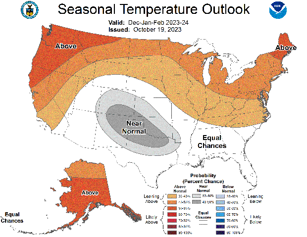
No areas of the U.S. are forecast to have colder-than-average temperatures between December and February, according to the NOAA.
As for moisture, areas with the highest chances of above-average moisture are across the portions of California stretching to the Gulf Coast and Southeast.
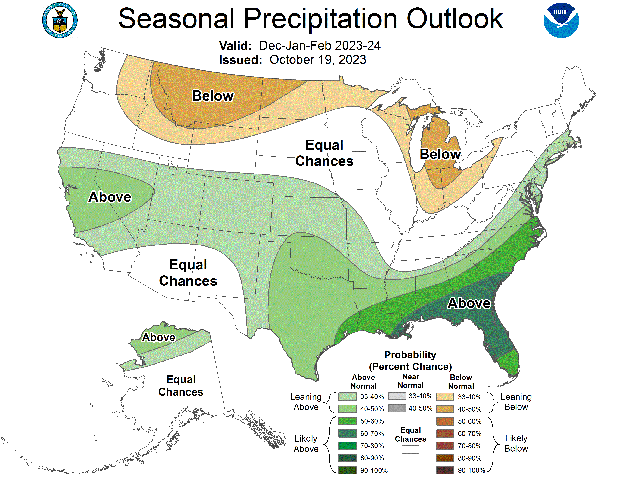
"More of the strongest signals we typically see is actually away from the west, is more across the southern southeast, Gulf Coast, Texas and up along the eastern seaboard for above-normal precipitation," Gottschalck said.
Drier weather is expected further to the north across the northern High Plains and Great Lakes region.
Where does Northern California stand?
This winter, most of Northern California is forecast to be warmer than average and wetter than average.
But north to south, California is not expected to have the same winter impacts thanks to the return of El Niño.
"Typically, that means above-normal precipitation across Southern California and it has mixed signals here in Northern California. We've seen very dry El Niño winters and very wet El Niño winters, so not a slam dunk as far as our winter is concerned," Courtney Carpenter, meteorologist at NWS Sacramento said.
The winter outlooks help show what signals forecasters should look out for but do not give an exact answer as to what we'll see.
"These outlooks don't tell you when it's going to rain, how much it's going to snow, how many storms we're going to get. So they just predict kind of an overall climate pattern but don't give us any of the details that impact us here locally," Carpenter said.
Therefore, a drier winter is still not out of the question.
"The outlooks are probabilistic for a reason so what we are forecasting are what we believe is the most likely outcome," Gottschalck said.
Forecasters say these outlooks do help to give everyone from local and state emergency services to you at home a heads up.
"We saw a really crazy winter last winter. We just want people to start to get prepared, be thinking about flooding, be thinking about those winter storms, and how they are going to prepare their families and their loved ones," Carpenter said.


