Rain chances continue: Here's when to expect heaviest amounts, drier weather

Scattered rain chances continue as we finish off the workweek. Through Thursday, rainfall amounts will be light and snow levels high as another round of showers returns. A few thunderstorms may be possible Thursday afternoon south of Interstate 80.
Snow continued to stay above the passes through the day Thursday, with snow levels above 8,000 feet. A few ski resorts have postponed their opening days this week because of the lack of snow and warmer weather.
But a bigger boost of moisture arrives Friday into Saturday, helping local ski areas as an area of low-pressure stays parked offshore, bringing us another wave of energy and a better shot of accumulating snow.
The Pattern
The upper low continues to spin well off the coast of central California, delivering a better chance of showers Friday afternoon through Saturday evening.
Friday into Saturday, the snow levels will be near 8,000 feet but then lowered to 6,500 - 7,500 feet in elevation Saturday night, below the passes.
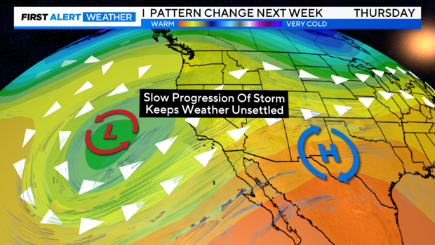
The storm's slow progression is keeping our weather unsettled for the next few days, but this area of low pressure will start to move inland on Friday.
A few thunderstorms will also be possible from Friday night through Saturday, mainly to the south and west of Sacramento. But we can't rule out an isolated storm across the valley.
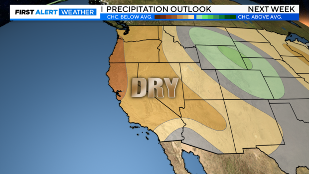
Looking ahead, our pattern shows a shift starting Sunday through next week as a ridge of high pressure builds in, leaving us drier and warmer through Thanksgiving week. This will be helpful for any holiday travel plans.
Rainfall Amounts
Looking at the future cast, the bulk of precipitation will be picked up through Friday night and Saturday.
Through Saturday, across the Sacramento area, .5'' to 1'' is expected. The heaviest amounts depend on where thunderstorms and defined rain bands set up.
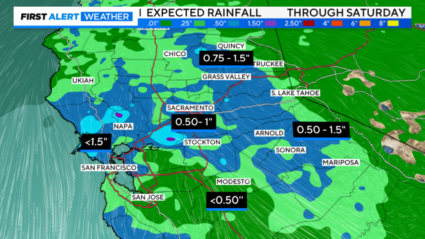
In the Central Valley, expect up to .5'' from south San Joaquin County into Stanislaus County. Closer to the foothills and Sierra, amounts trend higher up to 1.5'' of rain.
The Bay Area and Delta will see widespread rainfall, with portions of the coastal mountain ranges receiving 1-1.5" of rain, with up to 1'' around San Francisco.
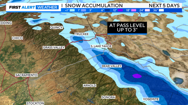
As for snow, it's going to depend on how quickly rain transitions to snow. Models suggest 1-3'' are possible over the northern Sierra passes above 7,500 feet. Snow levels could drop Saturday night below the pass level. Accumulations up to 8" are possible over the higher peaks, especially towards the south.
Make sure to stay with the CBS Sacramento First Alert Weather team over the next few days as we track any changes.
THE WEEKEND
Valley
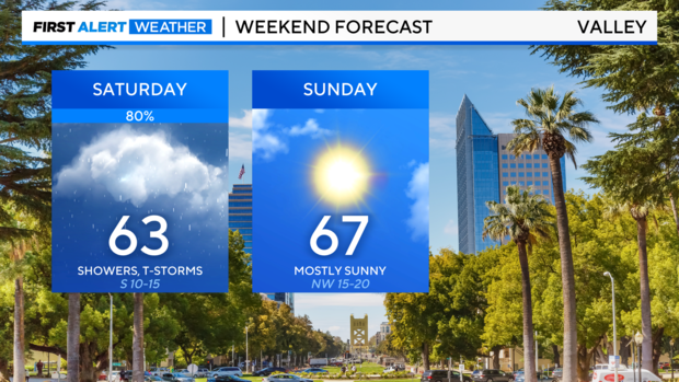
We'll start off unsettled this weekend, with rain showers to start the day. Through the afternoon, isolated thunderstorms will be possible. Highs on Saturday will be in the low 60s as a cold front sweeps through.
By Sunday, we start to dry out and warm up. Sunshine returns through the afternoon with clear skies. Sunday will be a better day to get outside for any weekend plans. But it will be breezy, with winds up to 20 miles per hour and highs in the mid-60s.
Foothills
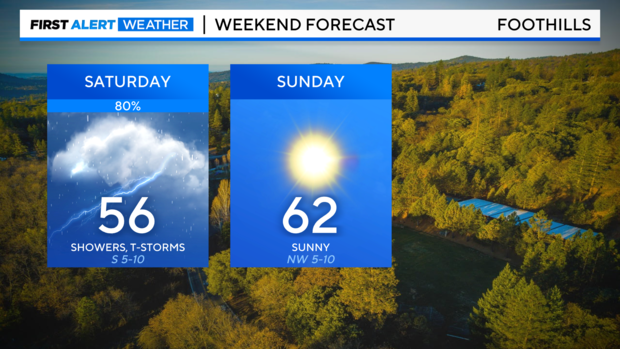
Unsettled and cool to start the weekend. Expect widespread rain showers and afternoon thunderstorms throughout the day on Saturday. Highs in the mid to upper 50s.
By Sunday, expect more sunshine and drier weather. Light breezes return through the day around 5-10 miles per hour with highs in the low 60s to finish the weekend.
Sierra
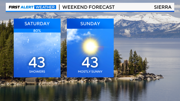
It'll be a cool weekend across the Sierra, with periods of rain and snow on Saturday morning. Showers become mainly rain through the afternoon as snow levels hover above 7,500 feet, dropping into the evening. Highs on Saturday are in the mid-40s.
Sunny weather returns Sunday, but temperatures stay cool with highs in the mid-40s through the afternoon.
Delta
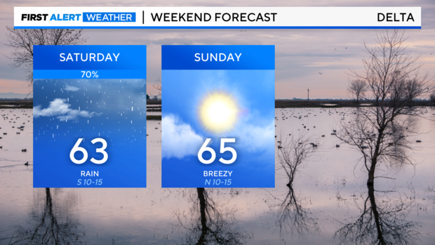
Expect showers and isolated storms to start the weekend. Saturday will be the most active day of the weekend before a drier weather pattern settles in by Sunday.
Winds will stay breezy through the weekend up to 15 miles per hour with highs in the low 60s both Saturday and Sunday.
Bay Area
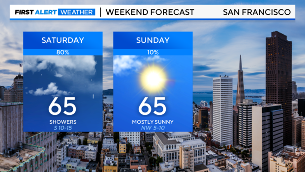
A wet weekend is in store across the Bay Area with rounds of rain showers expected on Saturday but tapering off by Sunday. A few isolated storms may be possible through Saturday afternoon.
By Sunday, expect partly cloudy skies with highs this weekend in the mid-60s.


