Incoming storm packing damaging winds; Residents brace for toppled trees, downed power lines
SAN FRANCISCO -- While a potent atmospheric river will unleash its wrath on Southern California on Tuesday, the San Francisco Bay Area will not escape unscathed.
The spinning low pressure system parked off the Bay Area coast will whip up damaging winds, blasting them into the South Bay and East Bay hills. The National Weather Service has issued wind advisory, warning that "saturated soils can make it easier for trees to fail."
"Depending on the exact track and strength of the system, wind gusts have the potential (30-50%) to exceed 50-60 mph in areas from the Santa Cruz Mountains inland into the East Bay Hills/Diablo Range and southward," forecasters predicted.
Another big blow, hardly the kind of forecast local residents wanted to hear. Just last week, a fierce wind storm left 300,000 customers in the Bay Area without power for hours up to days.
"These winds will result in an increased potential for downed tree limbs, trees and powerlines resulting in isolated to scattered power outages," the weather service said.
PG&E issued a release regarding the incoming storm, noting that last week's storm was the 13th major storm event in the utility's service area in the past 75 days. Officials said that storm was the most significant storm in terms of customer impact in the Bay Area since 1995.
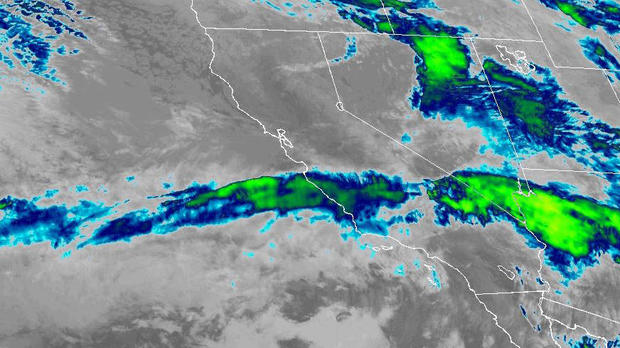
While the atmospheric river being hurled at California by the spinning low will be targeting San Luis Obispo southward with 3 inches or more of rain, the Bay Area will also be getting up to an inch to 1 1/2 inches.
"Light to moderate rain will develop late Monday night offshore and then spread inland over the Bay Area and Central coast through Tuesday morning," forecasters said. "By about sunrise on Tuesday, rain will increase in coverage and intensity with a 10-20% probability of isolated thunderstorms."
The new storm system will be adding to the woes left behind from the 12 atmospheric rivers that had slammed into the once drought plagued region since Dec. 26.
New evacuation orders were in place Sunday near two small central California towns where a levee was breached following recent downpours, as yet another winter storm brought the threat of major flooding.
The agricultural communities of Alpaugh and Allensworth, home to a total of about 1,400 people, were ordered evacuated because of "the possibility of residents becoming isolated due to impassible roadways," the Tulare County Sheriff's Office said in a statement.
A flash flood watch was issued for parts of the San Joaquin Valley in Tulare and Fresno counties, as well as for Sierra Nevada foothill areas, said the National Weather Service in Hanford.
Crews worked Saturday to repair a breached levee along Deer Creek just north of Allensworth, a historically Black town in southwestern Tulare County, according to Cal Fire spokesperson Jazz Shaw.
Meanwhile, forecasters said the Sierra could be getting a couple feet of new snow added to their impressive season totals from the two storms this week.
At the UC Berkeley Central Sierra Snow Lab, the season totals surpassed 670 inches Monday morning.
"With 7.7" (19.5 cm) of #snow over the last day, '22/'23 has passed '82/'83 as the 2nd snowiest season (Oct 1 - Sept 30) since the CSSL was built in 1946!," the researchers tweeted. "We now have a season total of 677" (56.4 feet."


