How our recent wet weather is making an impact across Northern California

Over the last week, Northern California has gotten a great dose of moisture. From heavy rain, isolated thunderstorms, and snow in the Sierra, it's been an unsettled pattern. But how has this wet weather helped us so far this month and season?
Rainfall
Recent storms have been beneficial to our area so far this year. Especially as 2023 ended on a drier stretch.
Looking at the Capital City, Sacramento has seen a good round of storms so far this month.
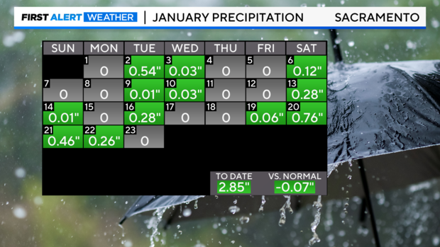
The best rain we've received so far came last weekend (Jan.19-22) with 1.54'' total in four days.
In total, our month is still 0.07'' behind normal.
Looking at our water year, from October 1, 2023, to now, this, too, is still falling behind.
As of Tuesday, Sacramento has seen 7.94'' of water this water year so far. In a normal year, we typically receive above 9 inches of moisture in the middle of January.
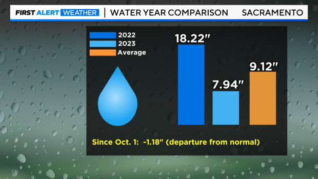
As we know, all years can vary, and last year was the exception. The 2022 water year received 18.22'' of moisture from several atmospheric rivers last winter.
However, not all cities are falling behind for the month.
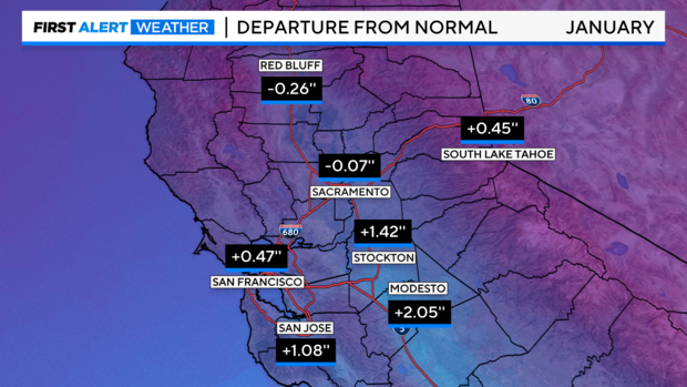
San Francisco, San Jose, Modesto, Stockton and South Lake Tahoe are above normal this month. Modesto, in particular, is 2 inches above the normal, thanks to our most recent round of storms. This now puts the city at nearly 4 inches of rainfall this month.
These numbers are taken from the National Weather Service's official climate sites, recording climate data in 30-year spans since the 1800s.
Snowpack
Our snowpack so far this year has been lagging, as most of the storms we've seen have been warmer. These force snow levels higher, to above 6,000-6,500 feet in elevation.
This means in areas below 6,000 feet, precipitation falls as mainly rain.
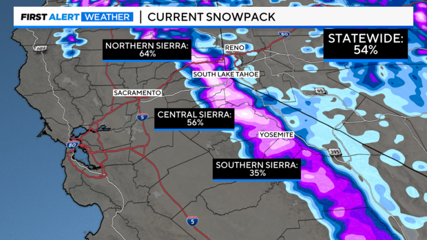
As of Wednesday, the statewide snowpack is at 54% of normal.
We have made gains this year. On December 31, the snowpack was measured at just 26 percent of the average for that time of year, with 2.5 inches of average snow water equivalent.
In January 2023, the California snowpack was measured at 240 percent of the historical average. Yet, storms last year were an anomaly.
The change we need to see before our wet season (December, January and February) ends is colder storms to help build our snowpack to help us during warmer seasons.
More rain next week?
Our weather pattern is changing at the end of January into early February.
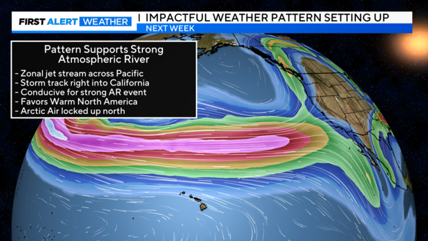
This pattern supports a strong atmospheric river setup, with a more zonal jet stream across the Pacific and a storm track favoring California.
The National Oceanic and Atmospheric Administration's climate prediction models have noted the trend and have placed most of the west and southwest in an above-average category for precipitation.
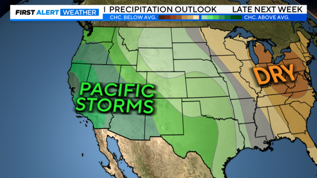
There are still a lot of details to sort out as this gets closer and models may change, but this is a good indication that more wet weather may be moving in.
Make sure to stay with the CBS Sacramento First Alert Weather team for the latest updates.


