How is this year's water year is shaping up? Where does the state's water supply stand?

We've been fortunate this season to pick up a beneficial amount of rain and snow across Northern California.
Of course, our current season does not near the 2022-2023 season, which had a record 33.56 inches of precipitation, but two back-to-back wet seasons never hurt a drought-prone Golden State.
The El Niño climate pattern may be responsible for yet another productive winter, but how are we shaping up this water year as we get closer to summer?
Statewide snowpack
After a dry start to 2024, March storms helped provide a boost to the snowpack. For the second season in a row, the state is in a great place as we near summer.
As of Thursday, the statewide snowpack is at 82% or normal, which is very good for the end of the peak snowpack timeframe.
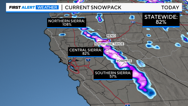
The northern Sierra holds the most snow at this point in May with 108% of the average. The central Sierra is at 82% of normal and the southern Sierra is at 57%.
Back in April, the California Department of Water Resources reported statewide snowpack was at 110% of the April normal, which was above average for the season. The April measurement is critical for water managers as it's considered the peak snowpack for the season and marks the transition to spring snowmelt into the state's rivers and reservoirs.
A healthier snowpack, the better as the months get warmer and storms become limited. On average, the Sierra snowpack supplies about 30% of California's water needs.
As snow continues to melt in the next few months, make sure to use caution on local waterways. Rivers will be running cold and fast. Be prepared and wear a life jacket before you get in.
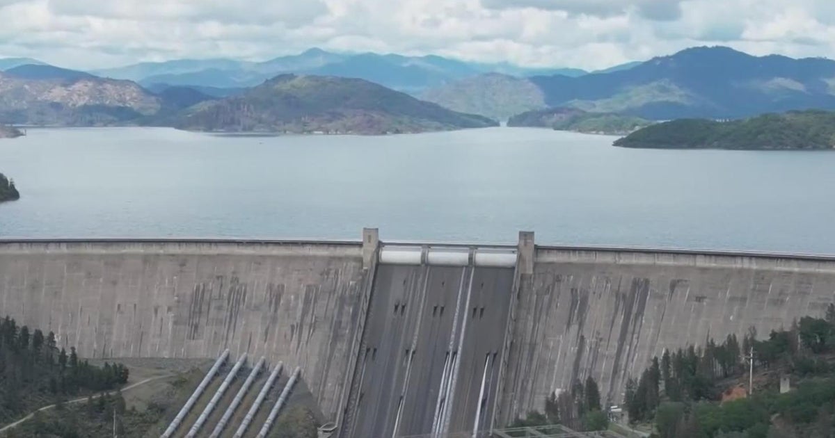
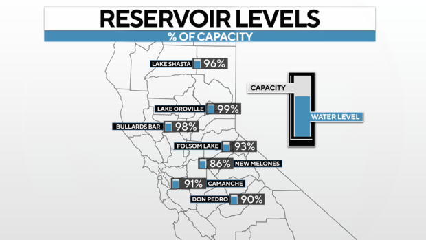
Reservoir levels
California's reservoirs remain in good shape thanks to record storms in 2023 and again this season.
Most northern California reservoirs remain above 90% of average capacity as of Thursday.
More reservoirs have been carrying more water this year than average thanks to 2023's storms, but storms this season have made sure reservoirs stay filled.
Overall, statewide reservoir levels have elevated since storms in late 2022 and early 2023 brought several atmospheric rivers to Northern California, bumping overall water storage in reservoirs to over 100% of the historic average last year for the first time since 2019. This comes after years of drought the years prior.
California's reservoirs are not just affected by rainfall and the state's snowpack, but the flood control measures, too. Each reservoir is unique in how much water it can carry at one time to make sure it can hold more runoff when it comes. This can impact how much water is in an individual reservoir at a time, making our regional reservoirs a major part of the state's water supply.
The Sacramento water year
In Sacramento, the city's water year has been running very close to average with rounds of active weather this winter.
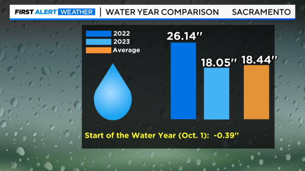
Since Oct. 1, the start of the water year, the National Weather Service's downtown Sacramento weather station has recorded 18.05 inches of precipitation as of Thursday. Typically at this point in May, downtown Sacramento usually reports 18.44 inches.
The majority of Sacramento's precipitation this year was picked up during 2024, with 12.96 inches of precipitation recorded since January 1. On average, Sacramento's wettest months are December, January and February. Over half of the city's annual rainfall tends to fall during that time.
In our previous water year, October 2022 to September 30, 2023, Sacramento reported 26.14 inches of precipitation, with a large bulk of it falling during the winter.
Between the start of October and late January in Sacramento, 10 inches would be considered a normal year. So this current water year is above average so far.
Summer outlook
The forecast heading into the summer is looking much warmer and drier.
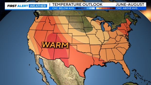
From June to August, NOAA's Climate Prediction Center outlooks have placed California in the "above average" categories for temperatures and moisture.
This checks out as summer nears. Of course, we can't rule out a few late-season spring storms or early fall storms this year. But the majority of us are now entering our driest period of the year.
Entering the summer, the big focus will be increased fire danger. As overgrown brush from back-to-back wet seasons dries out, fire danger increases. Make sure to stay fire-aware as summer approaches.
Stay with the CBS Sacramento First Alert Weather team for any updates to the forecast and updates to our water year.