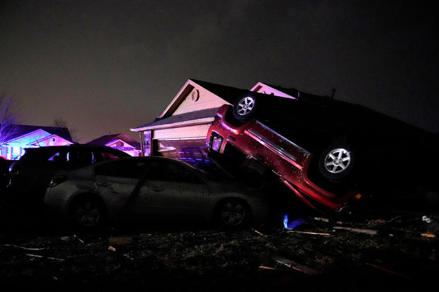
Tornado races through Norman, Oklahoma, injures at least a dozen, tosses vehicles around
Powerful storms with widespread wind gusts and reported tornadoes swept across Oklahoma and Kansas, leaving at least a dozen people injured, and many Michigan residents faced a fifth-straight day Monday without power following last week's ice storm.
In California, the National Weather Service said a series of winter storm systems will continue moving into the state through Wednesday after residents got a brief break from severe weather on Sunday.
CBS News weather producer David Parkinson said there's more severe weather in store for much of the nation this week.
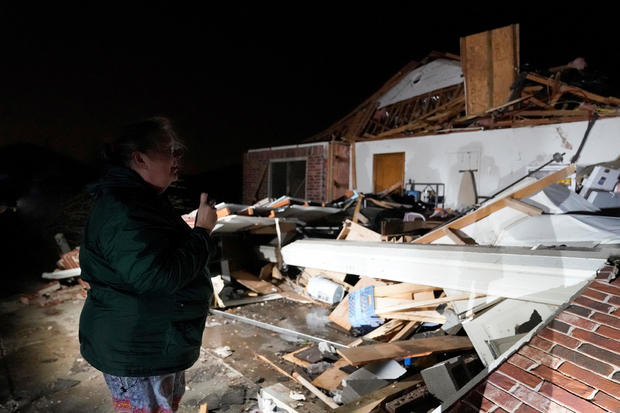
Storms moved into Oklahoma Sunday night from the Texas Panhandle. Widespread gusts up to 90 mph were reported in southwest Oklahoma with downed trees and power lines, road closures and damage to homes around Norman and Shawnee.
CBS Oklahoma City affiliate KWTW reported that a twister caused widespread damage in Norman, even tossing vehicles about — including one on top of another.
The city manager's office in Norman said a dozen people were hurt, none critically, adding that the extent of damage would become clearer after daylight and that a shelter was opened in a recreation center. All 12 patients who suffered storm-related injuries were admitted at Norman Regional Hospital, said Norman Police Chief Kevin Foster during a news conference on Monday. The hospital confirmed that none of those 12 patients suffered life-threatening injuries, Foster said. The police chief told reporters that he believes the most severe injury reported in connection with the twister is a broken leg, which he said was "due to a car accident."
As of Monday morning, authorities in Norman said they were not aware of anyone missing or otherwise unaccounted for in the aftermath of the storm. Foster mentioned a trailer park in an eastern section of Norman that was badly damaged in the twister, but he said that police had not received reports "of anyone who is missing from there."
Several homes, businesses and schools, including at least one local elementary school, were damaged in the storm, the police chief said Monday, adding that multiple roadways were still closed due to debris and downed power lines.
"We ask that the public stay aware of the danger of downed power lines and trees in the roadway," said Foster. The police chief also asked that anyone who encounters animals, like cattle, livestock or domesticated pets, wandering outside contact animal welfare immediately.
More than 15,000 homes and businesses had no electricity in Oklahoma as of 11 a.m. ET, according to PowerOutage.us. That number was down from about 20,000 power outages reported across the state three hours earlier. In Norman, about 9,000 customers were without power at the peak of the storm, according to the Oklahoma Gas and Electric Company. A representative from OG&E said the number of outages had decreased to about 3,000 customers by around 8:30 a.m. local time on Monday.
"We're here for you," said Darrel Pyle, the city manager for Norman, at Monday morning's news conference. "And we will not rest until everyone has been addressed and their needs met."
City and law enforcement officials in Norman said Monday that they had not been in touch with the federal government for assistance or resources. However, Foster said they "did contact the state and we did have some response from the state to assist with anything we need."
In hard-hit southeastern Michigan, still reeling from the ice storm and high winds, the state's two main utilities - DTE Energy and Consumers Energy - reported more than 93,000 customers were without power as of Monday morning. More than 61,000 of those were DTE customers.
PowerOutage said nearly more than 134,000 were in the dark across Michigan Monday morning.
Wednesday's ice storm coated lines and trees with a half an inch of ice or more. The storm was followed Thursday by high winds.
DTE spokesperson Cindy Hecht said, "The icing event ... is equivalent to a hurricane for coastal utilities. It was the amount of ice and high winds — the winds and the amount of ice accumulation on lines and branches."
The outages prompted some Democratic state lawmakers to call for legislative hearings in Lansing to question utilities about the long restoration times and reliability issues. "There will be hearings. We will be taking over," State Sen. Darrin Camilleri told WDIV-TV.
California, meanwhile, got a brief break from severe weather after a powerful storm a day earlier swelled Los Angeles-area rivers to dangerous levels, flooded roads and dumped snow at elevations as low as about 1,000 feet. The sun came out briefly Sunday in greater L.A., where residents emerged to marvel at mountains to the north and east blanketed in white.
Suburban Santa Clarita, in hills north of Los Angeles, received its first significant snowfall since 1989.
"We went outside and we let our sons play in the snow," resident Cesar Torres told The Santa Clarita Signal. "We figured, while the snow's there, might as well make a snowman out of it."
The weather service said Mountain High, one of the closest ski resorts to Los Angeles, received an eye-popping 7-and-three-quarter feet of snow during the last storm, with more possible this week.
San Bernardino County on Monday declared a local state of emergency, saying residents of mountain communities were either trapped inside or could not get back to their homes after several feet of snow fell over the weekend.
Residents of those mountain communities who were not on the mountain were asked to avoid the area to allow first responders and emergency crews access to the few roads that had been cleared by Monday.
"The Sheriff's Department and other first responders have had to divert resources to assist with several search and rescue calls for individuals engaged in non-essential travel across the mountain region," San Bernardino County supervisor Dawn Rower said in a statement. "This is why agencies urge the public to be patient and respect the travel restrictions and road closures."
Rain and snow were falling again Sunday in Northern California as the first of two new storms began moving in. Blizzard warnings went into effect at 4 a.m. Monday and were to last until Wednesday for much of the Sierra Nevada.
"Extremely dangerous and near to impossible mountain travel is expected due to heavy snow and strong wind," the weather service's Sacramento office warned on Twitter.
After fierce winds toppled trees and downed wires, about 65,000 utility customers remained without electricity statewide as of Sunday afternoon, according to PowerOutage.us. The majority of the outages were in L.A.
Days of downpours dumped almost 11 inches of rain in the Woodland Hills area of L.A.'s San Fernando Valley, while nearly 7 inches were reported in Beverly Hills.
In Valencia, north of L.A., county officials said the heavy rains eroded an embankment at an RV park and swept multiple motorhomes into the Santa Clara River, with emergency video showing one of the vehicles toppled on its side. No one was reported injured.
Rare blizzard warnings for Southern California mountains and widespread flood watches ended late Saturday. But Interstate 5, the West Coast's major north-south highway, was closed off and on due to heavy snow and ice in the Tejon Pass through the mountains north of Los Angeles. Emergency crews, meanwhile, worked to clear mountain roads east of LA of snow and ice.
CBS News' Parkinson said, "The same storm system that brought snow to Southern California and tornadoes to Oklahoma is now set to bring snow and ice from Wisconsin to Maine and severe weather from Illinois to Ohio. The severe threat won't be nearly as considerable as in Oklahoma, but damaging wind and an occasional tornado are possible in places like Indianapolis, Columbus and Cincinnati.
" ... Snow and ice are the threat Monday into Tuesday morning for Wisconsin and Michigan. The accumulations of ice could be significant in Michigan and Wisconsin with as much as a half inch of ice in places like Grand Rapids and Green Bay, and there could be half a foot of snow north of there.
As the storm moves east, Parkinson said, much of the Northeast will get its "first shovelable snow. ... We are looking at 3 inches in NYC and Boston and 6 inches in many NYC and Boston suburbs, plus much of New England. There could be sleet mixed in, too.
At the same time, he said, more storms will hit the West. "This won't be as historic in terms of low snow, but we do again have California blizzard warnings," Parkinson pointed out. "This time, it covers the Sierra, including Lake Tahoe. We're looking at a max of 6 feet of snow, and winds gusting to 100 mph at the top of mountains, and widespread 50+ mph winds gusts" Monday and Tuesday.