U.S. winter outlook: Wetter South, warmer North and "more potential climate extremes," NOAA says
The upcoming winter season could be warmer than usual for much of the continental United States, with rain and snowfall estimates departing from average in both directions depending on the location, forecasters announced on Thursday. An updated U.S. winter outlook released by the National Oceanic and Atmospheric Administration shows how weather patterns may shape up across the country in the coming months — and how El Niño may impact the forecast.
"These outlooks provide critical guidance on the upcoming season for many industries and sectors of our economy, from energy producers to commodities markets to agricultural interests to tourism," said NOAA chief scientist Sarah Kapnick in a statement, noting that the months ahead could bring "a strengthening El Niño and more potential climate extremes in an already record-breaking year."
Forecasters unveiled their latest weather outlook as El Niño remains steadfast heading into winter, which meteorologists generally define as the three-month period between December and February, when temperatures in the Northern Hemisphere are typically lowest. A phenomenon that recurs every few years, this will be the first time since 2019 that El Niño is in place leading into the winter season, NOAA said. How it influences weather in the U.S. over the course of the season is forecast to be fairly typical, according to the new outlook that suggests the northern and far western bands of the continental U.S. and will experience a winter that is warmer and drier than average, while southern states should expect a much wetter winter than usual with generally average temperatures.
The agency on Thursday said that the odds of a warmer winter than average are greatest in Alaska, the Pacific Northwest and northern New England, while a large section of the middle of the country will see seasonal average temperatures that are near normal.
Winter will most likely be wetter than average in northern Alaska, the southern Plains, Gulf Coast, Southeast, lower mid-Atlantic region and parts of the West, from California to the south-central Rocky Mountains, according to NOAA. Portions of the northern Rockies and central Great Lakes region will likely be drier than average, especially in Michigan, northern Ohio and northern Indiana.
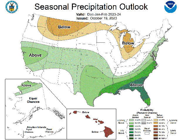
The wetter forecast across the Southeast, the Gulf Coast and Texas is expected to improve ongoing drought conditions in those places, although forecasters predict that drought will continue in the northern Rockies, northern Great Plains and parts of the desert Southwest. Drought may even develop in areas where a drier winter is forecast, like the Pacific Northwest and Hawaii.
"According to the U.S Drought Monitor on October 17, a third of the U.S., including Puerto Rico, is in drought," Brad Pugh, the operational drought lead at the Climate Prediction Center, said in a statement. "During late October, heavy precipitation is likely to result in drought improvement for the central U.S. El Niño with its enhanced precipitation is expected to provide drought relief to the southern U.S. during the next few months."
El Niño is a climate pattern defined by higher sea surface temperatures and precipitation across a block of the equatorial Pacific Ocean that influences weather across the world and tends to impact the U.S. significantly. It is considered the warm phase of the El Niño-Southern Oscillation, or ENSO, cycle, an alternating system of climate phenomena that shift based on trade wind patterns and how they affect ocean temperatures. El Niño officially arrived in June, taking the place of its counterpart, La Niña, which is the cooler ENSO phase. Both are determined by sea surface temperatures and precipitation levels outside of the neutral norm in that block of the Pacific south of Hawaii. When they are higher than usual, the ENSO cycle enters El Niño.
The strength of El Niño usually determines how much, or how little, it influences weather patterns nationwide and globally. In the U.S., El Niño is usually associated with wetter conditions along the Gulf Coast and in the Southeast, which at times has been known to cause serious flooding. The warmer phase of the climate cycle generally results in warmer and drier weather in northern parts of the country as well as Canada. Last week, forecasters estimated that El Niño would continue into the spring of next year.


