King Tides: Using an app to measure rising sea levels
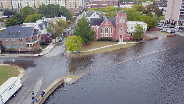
In Norfolk, Virginia, which is surrounded by water, the land barely rises above sea level, and the sea level is rising. So, flooded streets and front yards have become a way of life.
But now after years of fretting about the flooding, a group of ordinary people has come up with a novel response, reports correspondent Brook Silva-Braga.
As the tide rose, the water kept creeping toward John Bluming's house, which now sits on stilts
"The water comes up from Callie Bay, into the street," he said … and right into his yard. "After I bought the house, I realized it was a common occurrence."
"How much of a financial surprise was that?" asked Silva-Braga.
"About $90,000 to lift it up."
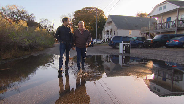
Low-lying Norfolk has always faced flooding from hurricanes, like Isabel back in 2003. But the sea water in Bluming's front yard was brought to land by nothing more than a high tide.
Sharon Beene lives here by the water, too, where kayakers frequently paddle down her street. She told us the house can still get flood insurance; they just had to cut power to the outlets on the ground floor.
The U.S. government says, globally, the sea level has risen more than three inches in just the last 25 years. And because of factors like erosion and ocean currents, some places have faced more rise than others.
Norfolk has evidence of that, thanks to a tidal gauge dating back to 1927. Derik Loftis, a researcher from the Virginia Institute of Marine Science, says that, since Sewell's Point gauge in the city of Norfolk was installed near the Naval base almost 100 years ago, sea level has risen by nearly a foot and a half.
Loftis says that foot-and-a-half of change comes not just from the water rising but also because over-development of Norfolk's marshy soil has been sinking the land. "By the year 2050, I mean, we're kind of expecting an increase that's somewhere between 0.7 to one foot of water," he said.
Dave Mayfield felt resigned to the problem three years ago, as he wrapped up a career as an environmental journalist for the local paper: "I was feeling a bit depressed," he said. "We're seeing flooding more, and more people are getting inconvenienced. And nothing happens. I wanted to do something that might make a difference, you know, at least in helping engage people."
So Mayfield got an idea: He knew each fall, the alignment of the moon, Earth and sun cause what's known as a "king tide" – an otherwise normal high tide that's especially strong and, more importantly, predictable.
"We would get as many people as possible out on one day to measure an unusually high tide," he said. "Have their data crowd-sourced into a model improving flood forecasting."
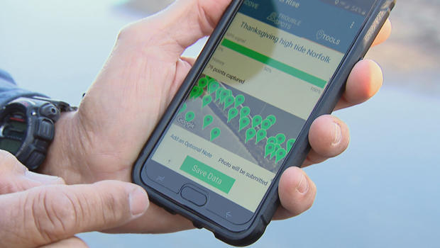
He partnered with a group that had developed a tide mapping app and dubbed the event "Catch the King."
To his surprise, more than 700 people turned out. Guinness certified it as the world's largest-ever environmental survey.
"I think what I underestimated was the innate desire of people to be part of something larger that might result in something good," Mayfield said.
There have now been three annual "Catch the King" events, and the idea has inundated other parts of the calendar. If the tide charts call for flooding in coastal Virginia, you'll probably find a mapper at the high-water mark.
"We walk along the waterline at high tide, and about every five feet we press a button [on the app], and that records our exact location on the GPS," said Bill Wheary, who showed Silva-Braga the outline he'd created by his markings.
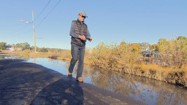
Mappers like Wheary have now pushed the app tens of thousands of times. Their readings end up in the hands of researchers like Derek Loftis. "It tells us whether our model's right or wrong, which scientists live and die by," Loftis said. "But also what's particularly useful is, it helps us find areas for potential improvements. For example, most of the flooding you'll see today is due to storm drainage systems."
And as Mayfield hoped, more than anything it's given ordinary people a way to do something about a problem no one person can do much about.
Wheary said, "Although we can't stop the tides, eventually some sort of preventative action is going to be, well, it is needed. And the more and more data that the scientists have, I think the better we'll be able to prevent the tide from causing harm to the neighborhood. May it all come out of what we're doing."
Mayfield said, "The unusually high tide that you might see on our annual project Catch the King is gonna be a routine high tide not many decades from now, so we provide, I think, a window into the future."
One off-shoot of this project has been taking water samples when the tide comes up, because it kind of marinates in whatever is on land.
A professor from Old Dominion University, Dr. Margie Mullholland, found that in a single king tide, an entire year's worth of runoff pollution is being deposited into the Lafayette River.


