Hurricane Idalia, a Category 3, brings "catastrophic" storm surge as it makes Florida landfall, forecasters say
Update: Hurricane Idalia made landfall on Florida's Gulf Coast Wednesday. Read the latest here. Our earlier story is below.
Hurricane Idalia, which was briefly an extremely dangerous Category 4 storm, weakened slightly Wednesday morning to a still major Category 3 as it moved over the Gulf of Mexico toward Florida, where it made landfall in Florida's Big Bend region, the National Hurricane Center said.
The National Hurricane Center said Idalia was bringing "catastrophic" storm surge and "damaging" winds to the area.
A Category 3 storm, with sustained winds of 111 mph or more, is the first to be labeled as a major hurricane by the hurricane center, which says a Category 4 has sustained winds of at least 130 mph.
The center stressed that the "change in wind speed does not diminish the threat of catastrophic storm surge and damaging winds."
As of 8 a.m. EDT Wednesday, Idalia's center was approximately 10 miles south-southeast of Perry, Fla. The storm was moving north-northeast at 18 mph with maximum sustained winds of 120 miles per hour. The hurricane center said Idalia's eye was moving "just inland" from the Big Bend Coast.
"In this part of Florida, particularly the Big Bend coast, we haven't seen a hurricane landfall of this intensity in many, many, many years," Michael Brennan, director of the National Hurricane Center, told "CBS Mornings" on Wednesday.
He said the region's shallow continental shelf adds to the storm's impact, with the hurricane's circulation pushing water inland, which is leading to catastrophic storm surge.
"We're gonna see, you know, not just the storm surge but potential for damaging winds extending well inland all the way across portions of north Florida, into southern Georgia, into places like Savannah, Hilton Head. We have hurricane warnings in effect for the fast-moving hurricane. It's going to bring those winds really far inland today and tonight," said Brennan.
Florida Gov. Ron DeSantis declared a state of emergency covering dozens of counties. Evacuation notices were posted in 22 counties and they were mandatory in eight of them, The Associated Press reports.
Many school districts along the Gulf Coast were closed through at least Wednesday. Several colleges and universities were also closed.
At a briefing Tuesday evening, DeSantis urged people to leave immediately if they were in an evacuation zone.
"If you stay hunkered down tonight, it's going to be too nasty tomorrow morning to be able to do it," DeSantis said.
"If you do choose to stay in one of the evacuation zones, first responders will not be able to get you until after the storm has passed."
Tolls were suspended early Tuesday morning along Florida's west coast, according to the governor's office, and dozens of shelters opened.
More than 63,000 Florida homes and businesses had no power as of 6:15 a.m., according to PowerOutage.us.
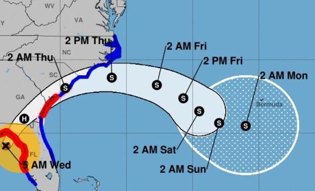
Hurricane path and map
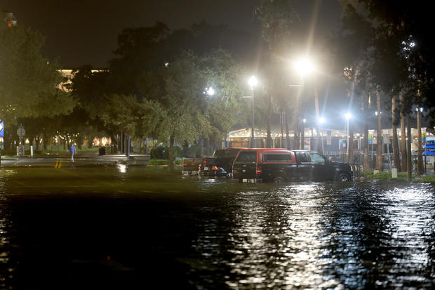
Idalia made landfall along the Gulf Coast of Florida Wednesday morning in the Big Bend region, with hurricane conditions extending along the coast.
You can see a live feed of Hurricane Idalia radar tracking in the video below:
Hurricane maps show the projected path of the storm and its impacts.
What category of storm will Hurricane Idalia be?
Hurricane Idalia was a Category 4 hurricane for a few hours overnight Wednesday then diminished in strength slightly to a Category 3.
"This is going to be a major impact ... so please prepare accordingly," DeSantis said at a news conference Monday.
Category 4 storms have sustained wind speeds of 130-156 mph and are expected to produce devastating damage, including downed trees, major damage to homes and days-, weeks-, or even months-long cuts to electricity and water, the hurricane center says. The area where a Category 4 storm hits could be uninhabitable for months, according to the center.
A Category 3 storm — like a Category 4 or 5 — is considered a "major" hurricane due to the potential for "significant loss of life and damage," the National Hurricane Center says.
Hurricane watches and warnings were in effect for parts of Florida's Gulf Coast as the storm strengthened.
State of emergency in effect
DeSantis expanded a state of emergency to cover dozens of Florida counties. He first issued a state of emergency on Saturday for 33 of the state's 67 counties to ensure communities "have time to prepare for the storm system which could have impacts along the Gulf Coast next week."
The Florida National Guard said it was deploying 5,500 personnel to support areas of the state that are impacted. Additionally, 14 aircraft, 2,400 high-wheel vehicles and 23 small watercraft were being mobilized.
North Carolina Gov. Roy Cooper also declared a state of emergency ahead of Hurricane Idalia, as did Georgia Gov. Brian Kemp.
"We are taking every precaution ahead of Hurricane Idalia's landfall tomorrow, and I am taking this additional executive action to ensure state assets are ready to respond," Kemp said Tuesday in a news release.
Parts of Florida's west coast and the Florida Panhandle — as well as southeast Georgia and the eastern Carolinas — could see up to 8 inches of rainfall from Tuesday through Thursday, with up to 12 inches possible mostly in areas near where the storm makes landfall, the National Hurricane Center says. That could lead to flash and urban flooding, "some of which may be locally significant."
Storm surge is also expected. The water level could reach as high as 16 feet from the Wakulla/Jefferson County line in Florida to Yankeetown, Fla. If the storm surge coincides with high tides. It could reach as high as 12 feet in other areas, and 6 feet in Tampa Bay, according to the hurricane center.
Tornado watches were issued for a large portion of the Florida Gulf Coast on Tuesday night.
What is storm surge?
Storm surge is "an abnormal rise of water generated by a storm," according to the National Hurricane Center. As a storm moves toward the coast, water is pushed to the shore and "piles up," which creates a surge.
If a storm surge and high tide take place at the same time, water levels will be even higher. The combination is known as storm tide.
Storm surge is one of the deadliest hazards of a hurricane. It is also "a very complex phenomenon," according to the hurricane center," because it depends on factors including a storm's wind speeds, size and angle of approach to the coastline, as well as the shape and characteristics of the coast.
A storm surge warning is in effect for Englewood north to Indian Pass, Florida. A storm surge watch is in effect for Chokoloskee to Englewood, including Charlotte Harbour, as well as for the mouth of the St. Mary's River to South Santee River, South Carolina.
In Crystal River, north of Tampa, city manager Doug Baber warned about the threat of storm surge – the worst of which isn't expected until high tide later on Wednesday.
"The surge is going to be pushing in later today. The biggest part of the surge is going to be around 4:30 … due to the high tide," he said Wednesday on "CBS Mornings," warning people against having a false sense of confidence that they can go out on the roads before the surge arrives.
Brian Dakss and Nicole Brown Chau contributed to this report.