Looking ahead to Tuesday's winter weather in Metro Detroit

(CBS DETROIT) - We've been discussing this upcoming storm system for a few days now, and as we get closer, a better picture is forming, but we're not all the way there yet.
Despite a few lingering questions, we do have a couple of answers.
The first comes down to the individual parts of the system.
There are mainly two main possibilities right now until the low pressure moves off the Pacific and onto land for us to measure raw data finally.
Sometimes, these things take a while, unfortunately.
The most likely option at this time appears to be a setup where things start as snow early Tuesday, change to rain, and finish up as snow Tuesday night.
Windy conditions exist that will keep things interesting even with temperatures approaching the upper 30s during the day.
Why? The wind chill will remain below freezing, which will allow us to freeze bridges and overpasses and create a few icy spots on roads, even during the rainy part of the day.
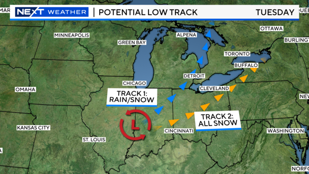
Snowfall remains entirely dependent on the actual storm track.
Pictured are the primary two options we have right now.
A more northerly track would give us a rain and snow mixture in stages, like I mentioned above, while a southerly track would hit us with snow straight away.
This is one of the main questions we still need to answer, and we responsibly can't until that raw weather balloon data finally starts coming in on Saturday.
Now you may be asking, 'Well, what are the odds one happens vs. the other'?
Again, this thing can and WILL shift around, but based on the circumstances and how previous systems have faired in the past, I would expect that northerly option to be the most likely.
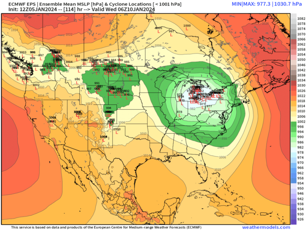
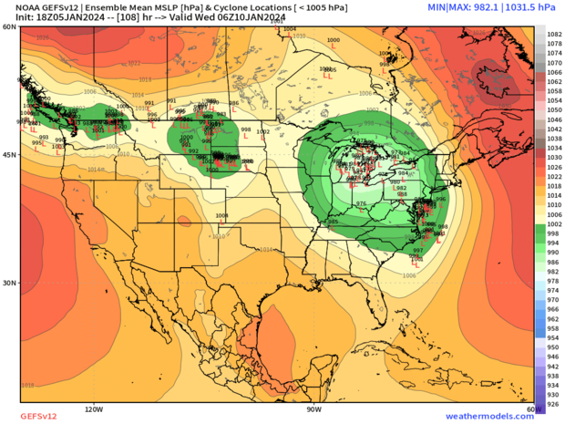
Pictured here are two of the main possibilities for those low-pressure positions.
Now that we are closer to Tuesday, all those little red L's are starting to get closer and closer together.
This indicates more model agreement on both of these scenarios, but also notice that each image is still different in the location overall.
The difference of a county-width amount can throw snow and rain amounts completely around, so it's paramount to make sure true, measured data comes in before sharing things like snow totals or even exact locations.
The bottom line is you should plan for light to moderate impacts due to the weather on Tuesday, with a potentially slippery morning commute because of any at-the-start snow we get.
Add to that rainfall for muddy yards during the day and falling temperatures at night, allowing icy spots to form, and the morning and evening hours seem to be the primary concerns for travel issues.
As the storm gets fully measured this weekend, we'll continue to update you on the latest information, like snow amounts (Finally!) and locations to go along with it all.


