Chicago Weather Alert: Winter storm warning begins Thursday


CHICAGO (CBS) -- A Winter storm warning for Chicago goes into effect Thursday at noon. Widespread snow develops Thursday afternoon and evening.
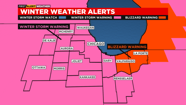
The National Weather Service has issued a winter storm warning from 9 a.m. Thursday until 6 a.m. Saturday (Christmas Eve) for DeKalb, Grundy, Kane, Kendall, LaSalle, and McHenry counties; from noon Thursday until 6 a.m. Saturday for Cook, DuPage, Lake, Kankakee, and Will counties; and from 3 p.m. Thursday until 6 a.m. Saturday for Lake, Newton, and Jasper counties in northwest Indiana. A blizzard warning has been issue for Porter County, Indiana, from 3 p.m. Thursday until 6 a.m. Saturday, where the combination of snow and strong winds will lead to dangerous to impossible travel conditions.
The winter storm arrives Thursday, with increasing snow showers in the early morning, then widespread snow by noon and continuing through the evening hours.

Travel conditions will become increasingly bad as the afternoon goes on, with increasing snow and slick roadways. Gusty winds will create blowing snow, reducing visibility and possibly creating blizzard-like conditions Thursday night into Friday, especially in northwest Indiana.

Temperatures will reach the low 30s by Thursday late morning, then fall drastically to the single digits by Thursday late afternoon. Feels like temperatures will be below zero by sunset.

Blowing and drifting snow continues Thursday night, producing dangerous travel conditions. Although new accumulation of snow may be minimal on Friday, gusty winds will continue to produce blowing and drifting through Saturday morning. Highs on Friday will be around zero, with wind chills -20 to -30 degrees. Lingering snow showers will be possible through Friday night with lows below zero degrees.

Single digits continue this weekend with wind chills -10 to -20 degrees on Christmas Eve and -5 to -15 degrees for Christmas Day.

Snowfall accumulation will range from 3 to 4 inches in the far west, to 4 to 6 inches in the Chicago metro area. The highest totals will be in northern Porter County and LaPorte County in Indiana, were snow totals could easily exceed 6 inches. It's also these two counties with the highest chance for blizzard conditions.


