Polar plunge with dangerous wind chills to persist through Wednesday in Chicago


CHICAGO (CBS) — The polar plunge sticks around through Wednesday morning, and Cold Weather Advisories remain until noon Monday.
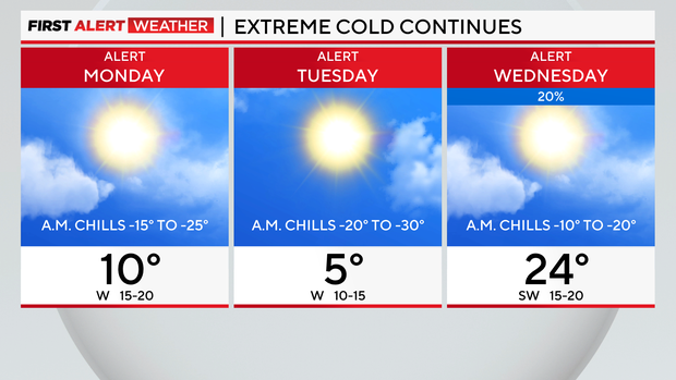
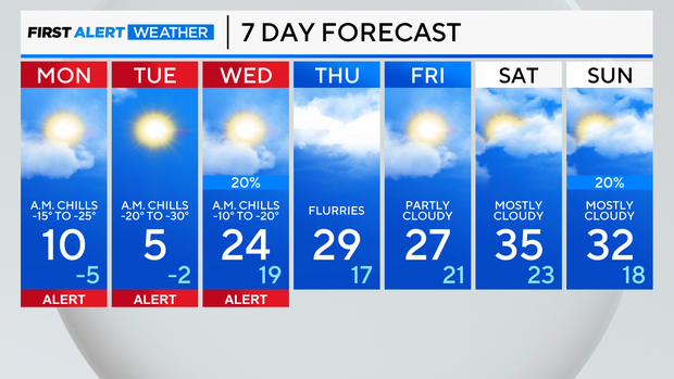
Wind chill readings will range from -15 to -25 degrees. Actual air temperatures Sunday night will dip to a low around -2, while highs Monday afternoon will peak toward 10 degrees.

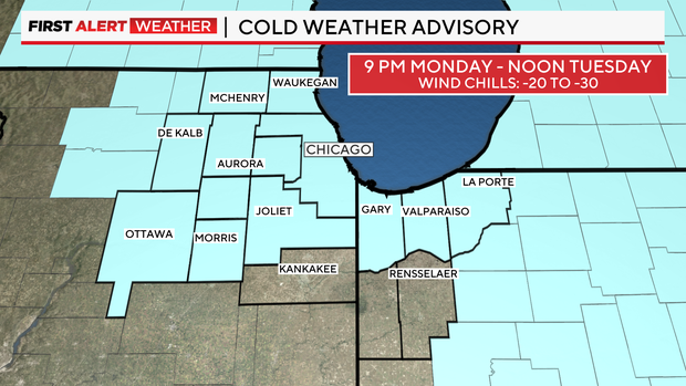
However, another blast of arctic air rushes in Monday night into Tuesday, prompting another Cold Weather Advisory for areas north of I-80 starting 9 p.m. Monday until noon Tuesday.
Wind chills in the alert areas will dip as low as -20 to -30.
Even for those not in the advisory area, it'll still be cold, so please make sure to stay warm, check on loved ones and don't forget about pets.
Actual low temperatures Monday night will be near -5, while highs Tuesday afternoon will be near 5 degrees.
It will be staying cold Wednesday morning, but by the afternoon a slight rebound with temperatures in the lower 20s.
A system is expected to move in around the Chicago area Wednesday into Thursday prompting scattered snow showers.
Temperatures rebound starting Wednesday afternoon with highs back in the lower 20s. Friday and the upcoming weekend, temperatures will be near-normal with highs in the upper 20s to middle 30s.
Forecast at a glance
Sunday night: Mostly clear skies, low of -2. Feels like -15 to -25
Monday: Partly cloudy, flurries. High of 10. Feels like negative single digits.
Monday night: Partly cloudy. Low of -5. Feels like-20 to -30.


