Chicago Weather: Winter Weather Advisory For Monday Morning; Up To 6 Inches Of Snow Possible
CHICAGO (CBS) -- With up to 6 inches of snow possible for the Chicago area on Monday, the National Weather Service has issued a winter weather advisory from midnight to 2 p.m. Monday.
Light rain was falling in the Loop as of just before 10 p.m. The snow was expected to begin falling late Sunday night as temperatures fall below freezing.
CBS 2's Mike Puccinelli reported that rain had turned to snow by 10 p.m. Sunday in Hoffman Estates – though no snow was sticking. Illinois Department of Transportation trucks were seen on the roads, though none were yet spreading salt.
In a period of about an hour, the temperature dropped from 39 to 34 as the rain transitioned to snow.
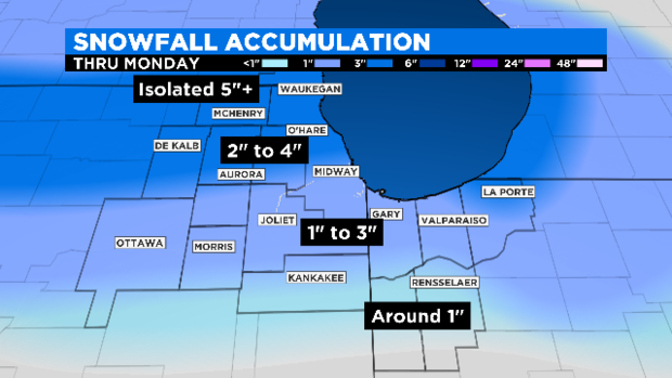
Total accumulations are expected to reach 3 to 6 inches, with the heaviest snowfall expected over the northern and central parts of the Chicago area.
Isolated areas along the lakefront could even see more than 6 inches.
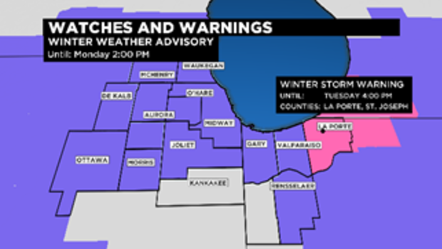
Meantime, a winter storm warning has been issued for LaPorte and St. Joseph counties in Indiana, from 4 a.m. to 4 p.m. Chicago time on Monday. Those areas could get 5 to 9 inches of snow during the storm.
Areas near the lake will see the most snow, with locally heavier snowfall possible for areas that find themselves parked under a lake effect plume.
Meanwhile, the powerful winds coming down Lake Michigan will also create lakeshore flooding and erosion concerns. Large waves from Sunday night until Tuesday could reach levels of 10 to 12 feet in northern Illinois and along the Indiana shore.
A lakeshore flood advisory is in effect for Cook and Lake counties in Illinois until noon Monday, while a lakeshore flood warning is in effect for Lake and Porter counties in Indiana until 4 p.m. Monday.
This is the first lake effect snow of the season.
A little rain-snow mix was expected to launch the precipitation. It will change all to snow by midnight, CBS 2 Meteorologist Robb Ellis reported.
Snow will continue to overspread the area from north to south through morning. Several inches of snow could be on the ground by 4 a.m. Monday.

Lows will drop into the mid-20s with winds picking up to 15-20 mph.
The windy snow will go on falling during the morning commute on Veterans Day.

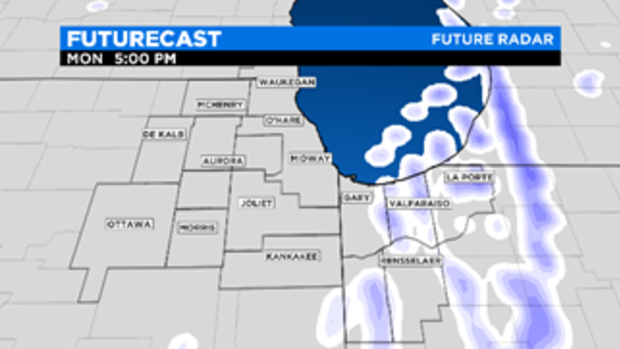
The wild card is how much lake effect snow we will pick up in northern Illinois before the lake effect conditions slide over to northern Indiana. Parts of Porter and La Porte counties in northwest Indiana could pick up more than 5 inches of snow in areas that receive lake effect.
The National Weather Service advises that for the city, the worst conditions will be between 5 a.m. and 11 a.m.
Times vary for the rest of the area – for Waukegan, the window is 3 a.m. to 9 a.m.; for Aurora, 4 a.m. to 10 a.m.; for Joliet, 6 a.m. to noon; for Kankakee, 8 a.m. to 2 p.m., and for Gary, 7 a.m. to 1 p.m.
Illinois State Police reminded everyone that extreme weather can make for dangerous driving conditions. They advised that motorists be sure their tires are properly inflated and make sure windshield wipers are in good shape and all fluids are at sufficient levels.
Also advised is carrying an emergency car kit with jumper cables, flares or reflectors, windshield washer fluid, an ice scraper, traction material, blankets, non-perishable food, water, and a first-aid kit, the ISP said.
Indiana State Police also advised that drivers leave earlier, increase following distances between vehicles, turn on headlights, and pack a blanket, water, snacks, and a cellphone charger. Drivers should also watch out for snow plows and emergency responders, and should clean entire windows and windshields of ice and snow – not just enough space to see through.
The Chicago Office of Emergency Management and Communications advised people to prepare ahead of time for their Monday morning commute. Meanwhile, the Chicago Department of Streets and Sanitation will put out more than 200 snow removal spreaders on Sunday night and add more as crews and conditions warrant.
To watch the city's snow removal fleet in real time, go to http://www.chicagoshovels.org.
Meanwhile, temperatures on Monday will likely be going down much of the day, reaching a high of 28 early in the day.
By midday Monday, snow is tapering off in the city, but lake-enhanced bands may set up in Indiana.
Meantime, the temperatures we experienced Sunday likely will be the warmest of the week, reaching only within about 10 degrees of normal. a high in the low 40s Sunday afternoon, but a cold front moving in from Wisconsin was set to send temperatures steadily falling all the way through Monday night.
The normal high this time of year should be the low 50s, but Monday's high will be only in the upper 20s.
The winter storm will be driven by a 15-20 mph northerly wind that gusts to 30 mph, meaning wind chills will be in the middle teens during the Monday morning rush.
Tuesday's high is now forecast at a mere 22. Lows will drop to the low teens on Monday night, with wind chills near zero and as low as minus 5 Monday night into Tuesday.
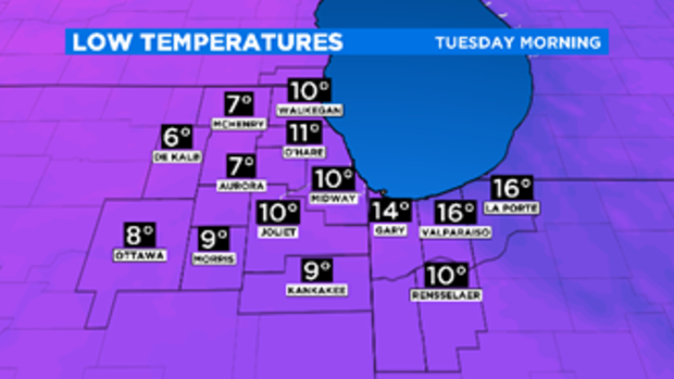
Early Tuesday morning, the forecast low is only 11. That's right, 11 – and that's not the wind chill factor, it's the actual temperature. Believe it or not, that would not set a record – the record low for Tuesday, Nov. 12 in Chicago is 8 degrees.
However, the forecast low of 28 will match the record low high for Nov. 11 in Chicago, and the forecast low of 22 for Tuesday will beat the record low high for Nov. 12, which is also 28.
The OEMC reminded everyone to take extra precautions in the cold and to be sure to check on seniors, those living alone, or neighbors and family – particularly those with disabilities.
The Fire Department also recommends that people refrain from using space heaters altogether if possible, and that any space heater that is used is UL certified and at least 3 feet from anything that can catch fire. Residents are also reminded they must have working carbon monoxide detectors that can detect leaks from a failing heating system.
Smoke detectors should also be kept in working order, and frozen pipes should only be thawed with a dryer or a heating pad – never candles or an open flame.
Those looking for access to warming centers or who have insufficient heat are advised to call 311 for immediate assistance.
Temperatures will start climbing again Wednesday, reaching the low 30s, and possibly rising to the 40s again by Friday.
Forecast-
Today: Cloudy. High near 40.
Tonight: Rain changes to snow, low in the upper 20s
Monday: Snow through about half the day, high in the upper 20s.
Tuesday: Lower 20s with sunshine.