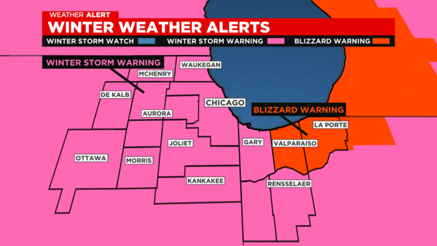
Chicago Weather Alert: Winter storm warning; blizzard-like conditions


CHICAGO (CBS)-- A winter storm watch is in effect with dangerous conditions ahead.
Conditions are expected deteriorate quickly throughout the day Thursday as snow develops. Snow began to ramp up by the mid- to late-morning, and will become widespread by the afternoon.
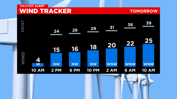
The building strong winds will lead to blowing and drifting snow will create dangerous conditions travelers.
Snow totals can range from 2" to 4" with higher amounts of snow in Porter and LaPorte counties in Indiana due to lake enhancement.
Temperatures continue to fall drastically to the single digits by late afternoon. Feels like temperatures will be below zero by late afternoon areawide.
Crashing temperatures are expected to cause icy road conditions for afternoon commuters. Wind chills dropping to -15 to -30 degrees by Thursday night. A warning: frostbite can happen in as little as 15 to 20 minutes with wind chills this low.
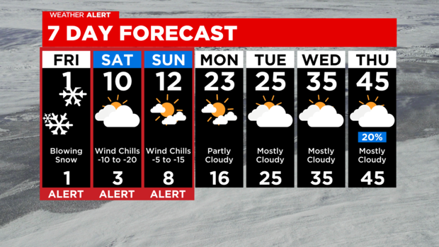
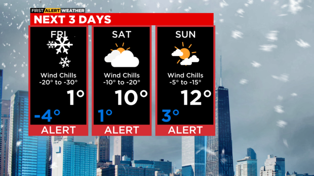
Snow chances decrease by late evening. Blowing and drifting snow continues Thursday night, producing dangerous travel conditions. Although new accumulation of snow may be minimal on Thursday overnight to Friday, gusty winds will continue to produce blowing and drifting through Saturday morning. Highs on Friday will be around zero, with wind chills -20 to -30 degrees.
Hour by Hour:
Noon-3pm: Snow showers, some will be heavy. Temperatures fall from 30s to 20s to teens.
3pm-5pm: Widespread snow, but heaviest should be moving through NW Indiana. Temps fall to single digits, below zero wind chills.
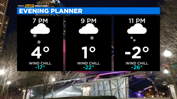
5pm-7pm: Snow showers and temps continue to drop. Wind chills of -10 to -20 degrees by early evening.
7pm-10pm: Snow starts to decrease, but the winds start to crank up. Blowing snow causing reduced visibility. Incredibly cold, wind chills around -20 to -35 degrees.
Single digits continue this weekend with wind chills -10 to -20 degrees on Christmas Eve and -5 to -15 degrees for Christmas Day.
Snowfall accumulation will range from 2 to 4 inches. Higher totals in northern Porter County and La Porte County in Indiana, were snow totals could easily exceed 6 inches.
THIS AFTERNOON: Falling temperatures with snow. Some snow will be heavy. Temperatures fall to single digits by mid afternoon, with wind chills below zero.
TONIGHT: Dangerously cold with snow likely in the evening, then blowing and drifting snow overnight. Low -4°, with wind chills -20 to -35 degrees.
FRIDAY: Blowing snow and dangerously cold. High 1°, with wind chills -20 to -35 degrees.
SATURDAY: Mostly cloudy and breezy. Some blowing snow. High 10°, wind chills of -10 to -20 degrees.