Chicago Weather Alert: One more quiet day before the winter storm


CHICAGO (CBS)--It's time to prepare as dangerous conditions arrive ahead of Christmas.
The National Weather Service has issued a Winter Storm Watch from 9 a.m. Thursday through 6 a.m. Saturday for DeKalb, Grundy, Kane, Kendall, LaSalle, and McHenry counties; from noon Thursday through 6 a.m. Saturday for Cook, DuPage, Kankakee, Lake, and Will counties; and from 3 p.m. Thursday through 6 a.m. Saturday for Lake, Porter, Jasper, and Newton counties in northwest Indiana.
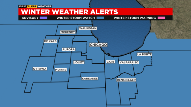
Those watches are expected to be upgraded to Winter Storm Warnings or Blizzard Warnings as the storm approaches.
Before the storm, it will be mostly cloudy and chilly for Wednesday with highs in the upper 20s.
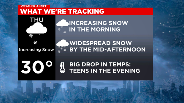
A winter storm arrives Thursday with increasing snow showers in the morning, then widespread snow in the afternoon and evening. Gusty winds will create blowing snow, reducing visibility and possibly creating blizzard-like conditions.
CBS 2 Chief Meteorologist Albert Ramon reported the latest high-resolution model at 10 p.m. Tuesday showed increasing snow showers beginning at 6 a.m. that will be widespread by midday – and heavy for the afternoon and evening commute.
The snow showers will continue through mid-evening.
Totals are now expected to top out at just 4 to 6 inches for areas west to Chicago, but 6 to 8 inches for the city and around the southern rim of Lake Michigan in Northwest Indiana. Porter and most of LaPorte counties in Indiana could see 8 to 12 inches, while northern LaPorte County into southwest Michigan could see a foot or more.
The American Model places totals for the city slightly higher at 7 to 9 inches.
Meanwhile, temperatures will reach the low 30s by Thursday late morning, then fall drastically to the single digits by Thursday evening. Feels like temperatures will be below zero by the early evening.
Blowing and drifting snow continues Thursday night, producing dangerous travel conditions. Although new accumulation of snow may be minimal on Friday, gusty winds will continue to produce blowing and drifting through Friday night.
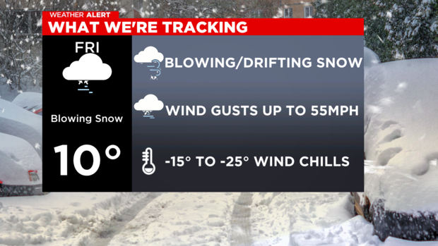
Highs on Friday will be in the single digits, with wind chills -15 to -30 degrees. Lingering snow showers will be possible through Friday night with lows just below zero degrees.
A big temperature drop is expected Thursday evening. By Friday, temperatures will drop from near 30 degrees to likely single digits with below-zero wind chills. Wind chills will likely be well below zero on Christmas Eve and Christmas Day, possibly as low as 25 below zero.
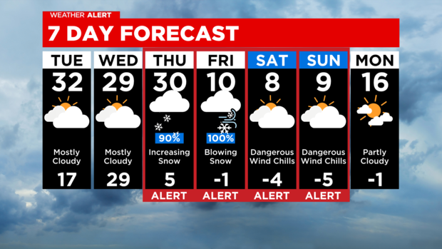
Single digits continue this weekend with wind chills -10 to -20 degrees on Christmas Eve and -5 to -15 degrees for Christmas Day.
Stay tuned for updates over the next 24 hours for this part of the forecast to be adjusted as new data comes into the CBS 2 Weather Center.
Timeline:
-Thursday morning: Scattered, mainly light snow showers.
-Thursday afternoon to evening: Steadier snow starting earlier and becoming more widespread by mid-afternoon. Travel becomes more difficult as the evening goes on.
-Thursday night to Friday morning: Wind-blown snow, with winds gusting to near 50 mph. Hazardous travel.
-Friday afternoon/night: Not a lot of new snow, but gusts keep blowing and drifting around from what's on the ground.
-Weekend: Snow tapers off by Friday night, but it will be dangerously cold with wind chills as cold as -20 to -25 degs Friday through Sunday. Blowing and drifting continues.
Hazards:
-Travel impacts starting Thursday afternoon into Friday evening.
-Power outages possible due to near 50mph gusts.
-Dangerously cold with wind chills -20° to -25 ° starting Friday and lasting through the weekend.
Stay tuned for updates over the next 24 hours for this part of the forecast to be adjusted as new data comes into the CBS 2 Weather Center.


