From atmospheric river to tornadoes to nor'easter, extreme weather strikes coast to coast
In a matter of days, the weather pattern has shifted from weeks of calm to one of the most dynamic fall patterns in memory. And while autumn is known for its wild swings, the pattern right now is literally off the charts, with the Northeast Pacific experiencing both its strongest and third-strongest storms on record in a matter of just 72 hours.
On Sunday, a wicked atmospheric river unleashed more than a foot of rain in parts of California, while a separate system spawned numerous strong tornadoes on Sunday night in the nation's middle. That same system will become yet another bomb cyclone — with hurricane-force wind gusts possible — for the Northeast coast on Tuesday.
All three of these systems have amazed meteorologists and, not surprisingly, are consistent with what climate scientists expect from a warming planet.
Powerful atmospheric river
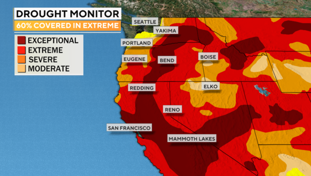
After months of one of the driest stretches ever observed in the West, capping off the worst drought in modern history, the Pacific jet stream came alive this past week and dove to the south, following a general cooling of the waters in the Northeast Pacific.
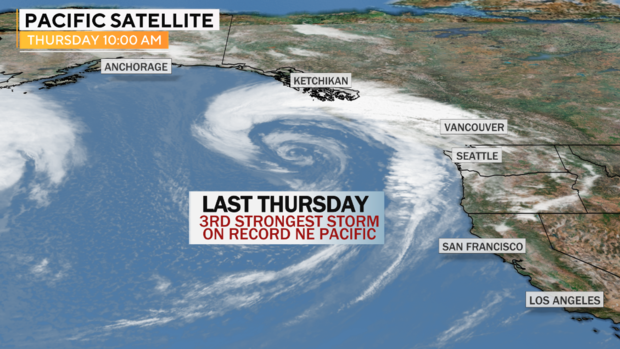
Last week the powerful jet stream raced across the Pacific Ocean, eventually spinning off a storm system which ended up becoming the third most intense low pressure on record in the Northeast Pacific.
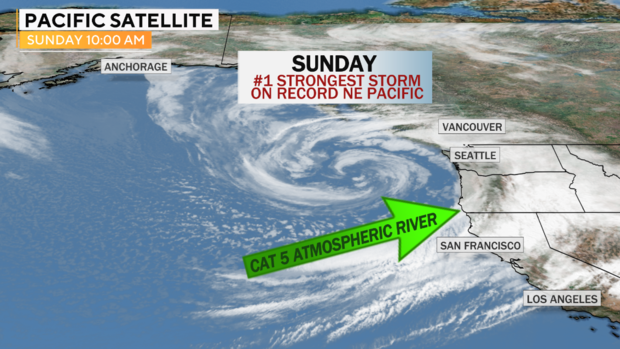
But that turned out to be just a warm-up. This past weekend, a wicked 200 mph Pacific jet stream helped fuel another storm on Sunday, this time even stronger. The pressure dropped to 942 millibars — the equivalent of a borderline Category 3 to 4 hurricane — and became the most intense cyclone on record in the Northeast Pacific.
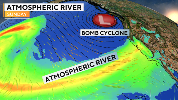
A strong jet stream alone does not always materialize into extreme weather. In order for that to happen a process called cyclogenesis needs to occur. Cyclogenesis is the process of a storm forming. It essentially takes the linear energy of a narrow band of intense upper level winds called a jet stream and converts that straight wind into a broad spinning wind, or circulation, like the two images above.
But the wind doesn't just circulate. It needs a mechanism in the atmosphere to force it to spin and in the case of the past few days that force was provided by a strong atmospheric block — a mountain of warm air — over northern Canada. The jet stream could not go through that block, so the wind was forced to divert, going around the block, which initiated rapid spinning and storms with record-breaking low pressure.
This process of storm formation is a natural occurrence, but it can be argued that climate change helped make these systems more intense. That's because high-latitude blocking is theorized to be more common in a warming climate, and stronger blocks can lead to stronger cyclogenesis.
Sunday's record-setting Pacific storm helped slingshot an extremely focused atmospheric river of tropical moisture into California. It was rated a Category 5 out of 5.
This storm produced up to 17 inches of rain in central-northern California and broke the all-time record for 24-hour rainfall in Sacramento — a rainfall event so heavy it was likely a once-in-100-year event.
The torrential rain was heavy enough to effectively end what was a very active wildfire season across the northern half of California and even put a small dent into what, up until this point, had become the worst western U.S. drought in modern history.
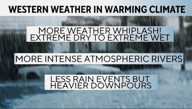
While it may seem odd for the weather pattern to switch from extremely dry to extremely wet in an instant, this is a natural characteristic of the Mediterranean climate of the West Coast. However, there is evidence that climate change is making these episodes of weather whiplash more common now, and the climate models indicate that trend will continue into the future.
Midwest tornado outbreak
At the same time the West was being pounded by a wicked atmospheric river, another storm was moving through the Midwest. While the event was well forecast to produce severe weather and even tornadoes, the ferocity of the storms was somewhat unexpected.
There were several Tornado Emergencies issued by the National Weather Service and in total 15 tornado reports in Missouri and southern Illinois.
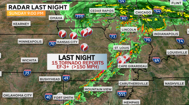
On Monday, the storm damage was still being surveyed, but the damage was extensive from winds up to 150 mph.
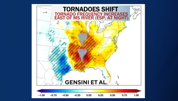
As the climate has warmed, there has been no clear trend in the number of tornadoes in recent decades. But one trend has emerged as a significant shift: Tornado frequency is increasing east of the Mississippi River over the Mid-South and decreasing over the area traditionally known as Tornado Alley in the lower Plains. This has meant tornadoes happening in more densely populated areas, most often at night — as they did Sunday night — which makes the storms all the more dangerous.
Nor'easter "bomb cyclone"
The storm responsible for the outbreak of tornadoes in the nation's midsection is now moving east. Just like the Pacific storm, this system will slow, bend and be forced to circulate more intensely by the Canadian blocking. Thus, what happened in the eastern Pacific will replicate itself along the East Coast, just not quite as strongly.
Heavy rain will move from the Ohio Valley into the Northeast Monday night and Tuesday as a coastal storm rapidly intensifies east of New Jersey. By Tuesday afternoon, the storm's barometric pressure will drop down to the equivalent of a Category 2 hurricane.
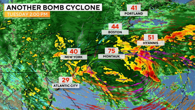
Storms that exhibit rapid pressure drops often overperform in terms of wind gusts. Eastern Long Island and southeast New England will see gusts over 60 mph, with some potential for wind gusts over hurricane force (75 mph+). With leaves still on the trees and very heavy rain softening up the ground, the potential for downed trees and power lines, and well as power outages, are possible, especially along the coast.
With a prolonged onshore flow, coastal areas prone to flooding should expect at least minor flooding issues at times of high tides. The storm will wind down on Wednesday morning, having dropped 3 to 5 inches of rain in its wake, adding to what has been one a very wet year for the major cities of the Northeast.
While there has not been much research on changes to the intensity of nor'easters due to climate change, the science shows that rain rates and rain totals will continue to increase due to both a warmer atmosphere and warm ocean.
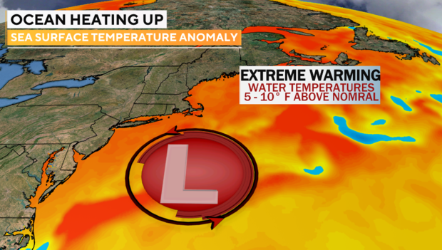
Typically, the energy release from higher rainfall rates can feedback into more intense cyclones. It stands to reason that a warmer ocean will result in more intense storms. As seen in the graphic below, sea surface temperatures off the Northeast coast are 5 to 10 degrees Fahrenheit above normal. This is not a temporary shift — it is systemic. Research has found that regions like the Gulf of Maine are warming faster than 99% of the oceans.