A tropical weather system is developing near Florida. Is this a sign of a busy season ahead?
The official start of hurricane season is still two weeks away, but the first named storm will likely form this weekend. With hurricane season broadly predicted to be very active this summer and fall, is this a signal those predictions are already materializing?
The National Hurricane Center is monitoring an area of low pressure getting gradually better developed near South Florida and the Bahamas. They give the system an 80% chance of development through the weekend. If or when it develops sustained winds equal to or above 39 mph, the storm will be named Arthur.
If Arthur indeed forms in the coming days, this would be the sixth straight season with early tropical development occurring before the official start of Atlantic hurricane season on June 1. The Atlantic basin has had named systems before June 1 every year since 2015.
Regardless, the system will produce heavy rain and wind gusts to tropical storm force — 39 mph or higher — in South Florida Friday and Friday night. Then the system will pull northeastward into the Bahamas on Saturday.
Early next week the storm is forecast to move up the Eastern Seaboard, just offshore, into cooler waters with gradually weakening likely. While odds are it should remain offshore, it does bear watching as another storm in the eastern U.S. may try to pull it closer. Either way, breezy winds, rough surf and perhaps even some minor coastal flooding is in the cards for the Eastern Seaboard.
It's worth noting that the system may either be a tropical system, which is a purely tropical low, with what is called a "warm core," meaning warm air makes up the whole system. Or it may be named a hybrid — subtropical system — which contains both warm and cold attributes. Hybrid systems usually take longer to development and typically do not get quite as strong.
This time of year subtropical systems are more common because they form with the help of cool pools of upper-level air left over from the winter and spring season. This helps destabilize the atmosphere, making it easier for systems to form when water temperatures are still not quite hot enough.
Typically, water temperatures above 80 degrees Fahrenheit are required for tropical formation. Right now, the general area where the system is forecast to form in the Bahamas is near or even slightly below that 80-degree threshold.
The early formation of tropical systems in recent years raises the question: Is climate change contributing?
Dr. Phil Klotzbach from Colorado State University, one of the nation's leading hurricane forecasters, said warming water may factor in, but it's more nuanced than that. "While several of the storms that have formed in the pre-season in recent years have formed over anomalously warm water, perhaps due to climate change, this system near south Florida is actually an exception," he said.
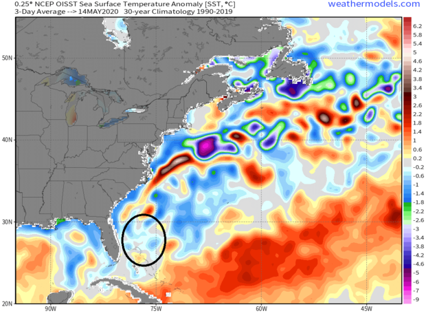
Referring to the graphic below, Klotzbach said, "Here's a plot showing current sea surface anomalies and the approximate forecast track of this disturbance. The waters near where the storm is currently located and where it is forecast to track are near their long-term average values."
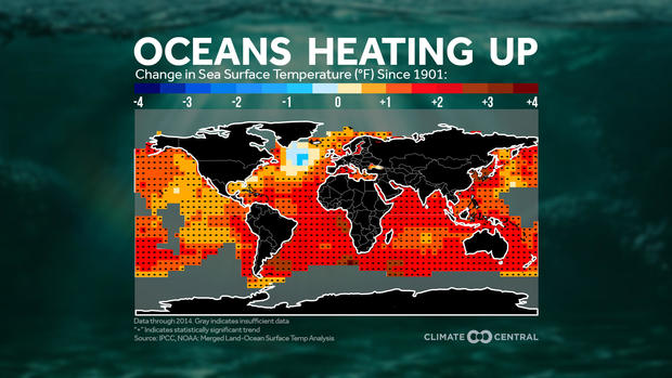
Water temperatures in the tropical Atlantic, and around the world, have increased over the past few decades, mostly due to human-caused climate change. That provides higher-octane fuel for tropical storm systems.
"There is very high confidence that the season length is linked to ocean temperatures," said NOAA tropical cyclone expert Dr. Jim Kossin. "The earliest starts have become earlier and the latest ends have become later, but there's a lot of uncertainty in the signal."
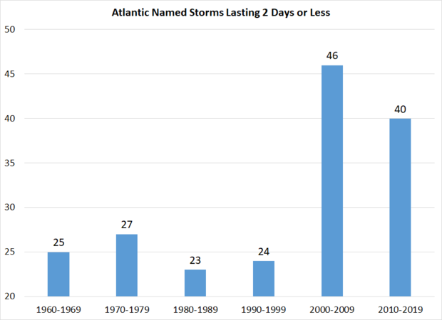
Some of that uncertainty is linked to our increased ability to evaluate storms. Klotzbach said the increase in marginal early or late season systems is partly due to better observational ability. "These are the exact kind of storms that became much more commonplace with the development of microwave sensors that allow for better detection of weak warm cores," he noted.
Kieran Bhatia, a hurricane and climate researcher and former postdoctoral fellow at Princeton University, cited the same general research and agrees with Klotzbach: "All this is evidence that it is very hard to produce meaningful trends that conclude earlier season storms are more likely due to climate change."
With that said, Bhatia said there is building consensus that a warming climate will lead to more intense storms in the future, as well as higher storm surge due to sea level rise and higher rainfall totals due to warmer air temperatures. "There is a growing body of evidence suggesting climate change is already increasing the magnitude of these hazards," Bhatia said.
With the increase in early-season storms, a debate has emerged in the meteorology community about whether to move the official start of the Atlantic hurricane season to an earlier date, perhaps in line with the East Pacific season which starts on May 15th.
CBS News reached out to the National Hurricane Center to find out if there are any plans to do this. Dennis Feltgen, a communications and public affairs officer meteorologist for NHC, said, "There are no immediate plans to change anything, only to open a discussion of the pros and cons."
An argument against starting the season earlier is the fact that early-season systems are typically not very strong or impactful. Klotzbach said, "In the satellite era (since 1966), we've only had tw hurricanes form prior to June 1st and no hurricane on record (since 1851) has made continental U.S. landfall prior to June 1st."
As for whether or not an early start spells trouble for the season ahead, Klotzbach said not so much. "Historically, early season storm activity tells you very little about how active the upcoming season is likely to be," he said.
But there are many other reasons to believe that this hurricane season will likely be a busy one. As CBS News first reported in late April, all of the major seasonal forecasts are calling for a well-above-normal season with 14 to 20 named storms possible.
The main reasons for these alarming forecasts are above-normal temperatures in the tropical development region of the Atlantic Ocean and cooling waters in the tropical Pacific, indicative of a possible La Niña forming by fall. La Niñas typically correspond with active Atlantic hurricane seasons.
Klotzbach's April forecast called for 16 named storms this season, above the average number of 12. At the time, Klotzbach felt there was some chance of La Niña developing, but since then he's come to believe it more strongly. "I would say that I'm certainly more in favor of weak La Niña conditions now for the peak of the season than I would have been one month ago."
Klotzbach's next seasonal forecast is due out in early June, and we will see if the increased risk of La Niña prompts him to increase his forecast numbers. Regardless, for those in potential hurricane zones, with the start of the season just two weeks away and the complications posed by the coronavirus pandemic, it would be a good idea to get an early start on preparing.