Downgraded Hermine, still dangerous, barrels across Florida
CARRABELLE, Fla. -- Hurricane Hermine made landfall early Friday along Florida’s Gulf Coast, sending battering waves against docks and boathouses as the state got its first direct hit from a hurricane in over a decade, then weakened into a tropical storm.
Hermine was moving inland over the eastern Florida Panhandle after coming ashore as a Category 1 hurricane at the state’s “Big Bend” early Friday morning.
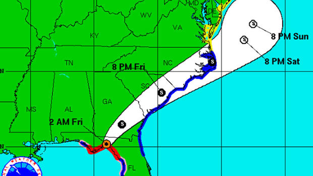
The National Hurricane Center said that, as of 5 a.m. EDT, the storm’s maximum sustained winds had decreased to just under 70 mph, with additional weakening forecast. The storm was centered about 20 miles west of Valdosta, Georgia, and moving north-northeast at nearly 14 mph.
But, the National Weather Service said Hermine’s threat was far from over:
The Hurricane Center said the hurrcane‘s eye came ashore just east of St. Marks, Florida, around 1:30 a.m. EDT with top sustained winds nearing 80 mph.
The “Big Bend” area is the mostly rural and lightly populated corner where the Florida peninsula meets the Panhandle.
Hermine was expected to push into Georgia, the Carolinas, then up the East Coast, with the potential for drenching rain and deadly flooding.
Projected storm surges of up to 12 feet menaced a wide swath of the coast, and an expected drenching of up to 10 inches of rain carried the danger of flooding along the storm’s path over land, including the state capital Tallahassee, which hadn’t been hit by a hurricane since Kate in 1985.
Rainfall of 4 to 10 inches was possible along the coasts of Georgia and the Carolinas by Sunday. Lesser amounts were forecast farther up the Atlantic Coast, because the storm was expected to veer out to sea.
The last hurricane to strike Florida was Wilma, a powerful Category 3 storm that arrived on Oct. 24, 2005. It swept across the Everglades and struck heavily populated south Florida, causing five deaths in the state and an estimated $23 billion in damage.
In Florida’s Pasco County, north of Tampa, authorities said flooding forced 18 people from their homes in Green Key and Hudson Beach. Pasco County Fire Rescue and sheriff’s deputies used high-water vehicles early Friday to rescue people from rising water. They were taken to a nearby shelter.
In Wakulla County, south of Tallahassee, a couple suffered minor injuries during the storm when they drove into a tree that had fallen in the road, County Administrator Dustin Hinkel said early Friday. He said storm surge of 8 to 10 feet damaged docks and flooded coastal roads.
On Thursday, Gov. Rick Scott had warned of the dangers of a strong storm surge from Hermine, along with high winds, downed trees and power outages, and urged people to move to inland shelters if necessary and to make sure they had enough food, water and medicine.
“This is a life-threatening situation,” Scott said as the storm approached. “It’s going to be a lot of risk. Right now, I want everybody to be safe.”
Scott, who declared a state of emergency in 51 counties, said 6,000 National Guardsmen in Florida were ready to mobilize after the storm passes. The governors of Georgia and North Carolina also declared states of emergency.
The City of Tallahassee was reporting 70,000 customers without power overnight, according to CBS Tallahassee affiliate WCTV.
Among the updates from CBS Tampa affiliate WTSP-TV:
Florida State University Deputy Police Chief James Russell tweeted video of the campus:
Many were taking no chances with Hermine.
Tallahassee resident Tom Duffy, 70, said Thursday he planned to reserve a hotel room for Friday night in the neighboring state of Alabama if downed trees caused the kind of power outages he expected.
“We’ve dodged bullet after bullet after bullet,” Duffy said, but added that Hermine has taken “dead aim” at the city, where blustery winds sent trees swaying before dawn.
Courtney Chason, a longtime resident of Carrabelle in the Big Bend area, warily watched as big waves began bashing some docks and boathouses, the angry surf flowing right over them. Water also crashed into yards closest to the shore.
“I’ve never seen it this high, it’s pretty damn crazy,” Chason said. “I hope it doesn’t get any higher; we need lots of prayers.”
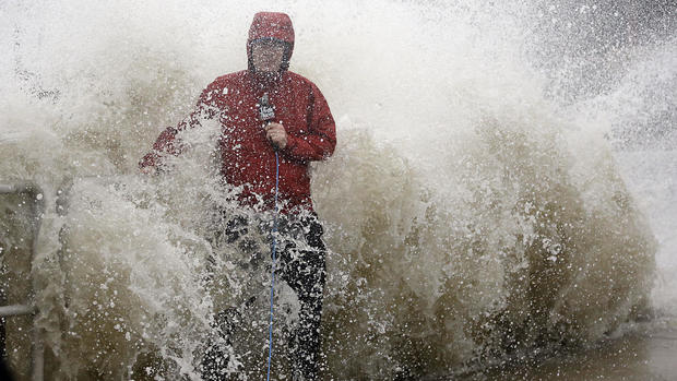
Hermine also sent heavy squalls with its outer bands over Gulf coast beaches elsewhere.
By Thursday evening, the normally wide, sugar-sand beach on Florida’s Treasure Island was entirely covered in water. Palm trees whipped in the wind. Nearby, folks stood gawking at the abnormally large waves and took selfies ahead of the storm.
The city of St. Petersburg was littered with downed palm fronds and tree branches, and low-lying streets were flooded.
On Cedar Key, a small island along the Big Bend, about a dozen people went from storefront to storefront Thursday, putting up shutters and nailing pieces of plywood to protect businesses from the wind.
One of them, Joe Allen, spray-painted on plywood in large black letters: “Bring it on, Hermine.” Despite the bravado, he said, “I’m worried. You can never fully protect yourself from nature.”
Chris Greaves and family members stopped in Tallahassee to pick up sandbags for his garage and the church they attend. Greaves said he lived in South Florida when Hurricane Andrew devastated the area in 1992. While he said he doesn’t expect the same kind of widespread damage, he warned that tropical weather is “nothing to mess with.”