East Coast braces for potentially historic Irene
Updated 11:20 p.m. ET
MIAMI - Forecasters say South Carolina is no longer under a hurricane warning and that Hurricane Irene is aiming its fury at North Carolina.
The entire coast of North Carolina is under a warning and watches extend all the way to New Jersey ahead of powerful Irene.
Forecasters at the National Hurricane Center Thursday evening said the coast of South Carolina from Edisto Beach north was still under a tropical storm warning.
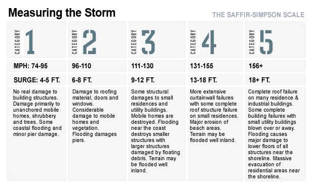
Maximum sustained winds for Category 3 Irene are still at 115 mph (185 kph) but forecasters expect it to gather strength as it hits the warm Atlantic waters.
In related news, authorities say the rough ocean churned up by the outer bands of Hurricane Irene have caused at least eight injuries and a near drowning in South Florida.
Palm Beach County officials say eight people were out on a jetty off Boynton Beach Inlet when a wave knocked them over. They say one person was taken to a hospital. Seven others were treated at the scene.
Up the coast in Jupiter, a man swimming in the ocean and couldn't be found right away. However, officials say he later was able to get ashore.
Meanwhile, thousands were fleeing an exposed strip of coastal villages and beaches off North Carolina on Thursday as Irene approached, threatening to become the most powerful hurricane to hit the East Coast in seven years.
Hours after a hurricane watch was issued for much of the state's coast, emergency officials expanded evacuation orders to include hundreds of thousands of tourists and locals in four coastal counties. The areas include the barrier island chain known as the Outer Banks, which is expected to take the brunt of Irene's first hit over the weekend.
President Obama declared that an emergency exists in North Carolina and authorized federal aid to the state in response to the hurricane effective Thursday, the White House announced in a statement.
Thursday afternoon, hurricane watches were out from North Carolina to New Jersey very close to New York Harbor. Nearly the entire coasts of North and South Carolina were under a warning.
New Jersey was the latest state to declare a state of emergency early Thursday afternoon. Gov. Chris Christie said the current track calls for New Jersey to face a "serious, significant event" and warned residents to "prepare for the worst."
Christie said he will not order mandatory evacuations unless absolutely necessary. However, the governor is asking people not to go to the Jersey shore this weekend and for those with rental properties to leave Thursday or Friday.
Earlier, the governors of North Carolina and Virginia made emergency declarations to free up storm recovery resources, while the Navy began moving dozens of ships out to sea from ports in Irene's path. And emergency officials all the way to New England were urging residents in low-lying areas to gather supplies and learn the way to a safe location.
Stay or go? Officials debate Hurricane Irene
Quake and hurricane insurance: A primer
National Hurricane Center storm tracker
The storm is expected to come ashore Saturday in North Carolina with winds of around 115 mph (185 kph). Forecasters predict it will then chug up the East Coast, dumping rain from Virginia to New York City before a much-weakened form trudges through New England.
"What we have to prepare people for is that a lot of these hurricanes in the northeast scoot out to sea and just miss the coast. This time our luck may be running out," CBS News hurricane consultant David Bernard said on "The Early Show" Thursday.
Based on the current storm track projections, Bernard says there are two scenarios shaping up: Bad and worse.
The bad scenario cuts the hurricane across Long Island and into New England as a large and strong Category 2 storm. This scenario brings tremendous storm surge on the back bays of Long Island and from the ocean. Massive power disruption and tremendous wind damage will result.
The worst scenario has the hurricane hug the coast all the way to New York City. This would bring tremendous storm surge and wind damage affecting everything from Maryland, right up to the Hudson Valley and across New England.
Most computer models suggest a worst-case scenario is the likeliest.
As the sun rose over North Carolina's barrier islands, tourists packed suitcases in their cars, while locals stocked up on food, water and gas. Traffic was moving briskly Thursday morning on the two-lane highway that cuts through many of the coastal communities, but many feared that would change.
"It's going to be a mess," said 66-year-old Buxton resident Leon Reasor as he stood inside a local bait shop. "Anyone who tells you they're not worried is a liar."
An evacuation order for an estimated 150,000 visitors took effect Thursday in Dare County, while its 35,000 permanent residents were told to begin leaving the next day. Tourists and locals in Hyde County were also told to move inland, as were visitors in Currituck County.
Carteret County officials ordered a mandatory evacuation for all visitors and non-residents starting at 1 p.m. Thursday.
Residents of the Bogue Banks -- a barrier island that includes Atlantic Beach, Emerald Isle and other beach communities -- are supposed to leave starting Friday at 6 a.m.
"It wouldn't behoove anyone to stay in these circumstances," Dare County emergency management spokeswoman Sharon Sullivan said. "Businesses are boarding up. Nobody can guarantee their safety."
Craig Fugate, the head of the Federal Emergency Management Agency, said residents should pay attention to local broadcasters to see if an evacuation order is made. Among the most important tasks, he said, was figuring out a safe place to go before hitting the road.

"When you evacuate, you want to know where you're going and make sure you have somewhere to go, not just get on the road with everybody else and hope you find some place," Fugate said Thursday on CBS's "The Early Show."
All along the East Coast, officials were calculating what they needed to do as Irene continued its march across the Caribbean toward the U.S. The Navy ordered 64 ships to leave Norfolk and other Virginia ports, saying they can better weather the storm at sea.
New York City Mayor Michael Bloomberg urged residents living in low-lying areas on Thursday to line up a place to stay on high ground ahead of possible evacuations this weekend. He said he would make a decision by late Friday on whether to evacuate neighborhoods along the water in several boroughs.
Even without hurricane-force winds, northeastern states already drenched from a rainy August could see flooding and fallen trees from Irene.
"You want to go into a hurricane threat with dry soil, low rivers, a half moon," New Jersey state climatologist David Robinson said.
That is not the case. The Garden State has gotten twice as much rain this month as in a normal August, and high tide happens at 8 a.m. EDT on Sunday, when Irene might be passing by.
The storm pounded the Bahamas early Thursday as a powerful Category 3 hurricane with winds at 115 mph (185 kph), largely sparing the crowded capital but destroying property in less-populated areas.
There were no immediate reports of major injuries or deaths but property damage appeared likely to be extensive on Acklins and Crooked islands, in the southern part of the chain, said Capt. Stephen Russell, director of the country's National Emergency Management Agency.
A settlement known as Lovely Bay was destroyed while at least 40 homes were badly damaged on the island of Mayaguana, the agency said. Authorities were still gathering damage reports and there were few details on the destruction.
Major damage was also anticipated on the island of Eleuthera, which was being battered Thursday morning, as well as Rum Cay and Cat Island. All were expected to have full and extended exposure to Hurricane Irene's powerful winds, which had weakened slightly Thursday to 115 mph (185 kph).
"That can be devastating for some of those islands," Russell said.
As the storm headed for the East coast, forecasters were no longer expecting it to turn into a fearsome Category 4 storm, but said that it would be a powerful and slow-moving Category 2 or 3 with the potential to cause greater damage and storm surge than a typical storm of its strength.
While the storm's path isn't definite, officials are taking nothing for granted.
In Maryland, inspections of bridges looking for cracks in the support piers and other structural features found no damage, according to state transportation agency spokeswoman Teri Moss. In Virginia, with a southeastern corner that could be in Irene's way, cities along the coast are reviewing their evacuation plans, said Laura Southard, spokeswoman for the state Department of Emergency Management.
Farther north, precautions so far were mainly wait-and-see as officials watched for developments in the forecast.
New York City officials had begun preparations to evacuate residents from low-lying areas of the city if necessary. The city's subway stations and tunnels would likely be flooded in places, and officials plan to shut the system down ahead of time to reduce damage to the infrastructure.
Roads and bridges in Massachusetts are likely to bear the weather in good condition, said Peter Judge, a spokesman for the Massachusetts Emergency Management Agency. But the agency is planning for flooding and is keeping an eye on the 3,000 public and private dams throughout the state.
North Carolina's Outer Banks have a long history of hurricanes, and building codes and emergency plans reflect that. Structures in the region are designed to withstand up to 110 mph sustained winds and gusts of up to 130 mph for three minutes. Evacuation routes are meticulously planned, down to the order in which counties hit the road.
Some of the region's most popular destinations rely on the ailing Bonner Bridge, which was built in 1963 and intended to last 30 years, to connect Hatteras Island to the northern Outer Banks. There's no other way to reach Hatteras except by boat.

The bridge handles about 2 million cars a year and the state DOT ranks it a 2 on its safety meter, with 100 being the highest, or most safe, designation.
"We're going to shift people and resources around to do what we need to do and keep the roads open," said North Carolina Department of Transportation spokeswoman Nicole Meister. The 2.7-mile bridge won't stay open if it's deemed unsafe -- which happened during Hurricane Earl last year -- but the state has an emergency ferry terminal ready in that case to get people off the island, Meister said.
Farmers in Eastern North Carolina said they are bracing for devastating crop losses. Strong winds and widespread flooding could mean billions of dollars in losses for those who grow corn, cotton, soybeans, tobacco and timber. While most farmers have disaster insurance, policies often pay only about 70 percent of actual loses.
Tourists in Buxton were sad to cut their vacations short, but said they understood the urgency of the situation.
New Jersey accountant John Robeson brought his wife and children -- ages 8 and 4 -- down for a week, but their vacation was cut short after three days.
"I'm disappointed," he said as he loaded his car. "You wait all year. Talk about it. Make plans for your vacation. And now this. It's a bad break."
His wife, Marlene, agreed. "I'm worried about traffic. I don't want to be stuck on the highway when the storm hits," she said.
As of 8:45 PM EST, the number of flights that have been canceled within, into or out of the U.S. is 1,016, according to FlightAware.com.
