Irma impact likely to be far worse than Hurricane Andrew, experts say
WASHINGTON -- For an entire generation in South Florida, Hurricane Andrew was the monster storm that reshaped a region. Irma is likely to blow that out of the water.
Bigger and with a 90-degree different path of potential destruction, Irma is forecast to hit lots more people and buildings than 1992's Andrew, said experts, including veterans of Andrew. At the time, Andrew was the costliest hurricane in U.S. history with damages of $26.5 billion in 1992 dollars (about $50 billion in current dollars), according to the National Weather Service.
"The effect of Irma on the state of Florida is going to be much greater than Andrew's effect," said Weather Channel senior hurricane specialist Bryan Norcross, who was a local television meteorologist hailed as a hero during Andrew. "We're dealing with an entirely different level of phenomenon. There is no storm to compare with this. Unless you go way back to 1926."
Florida Gov. Rick Scott warned on "CBS This Morning" on Thursday that "we just haven't seen this" level of damage, even with Andrew.
"You've got to listen to your local officials -- this storm surge can kill you," Scott said. "My biggest concern is people don't understand the amount of potential storm surge."
Kate Hale, Miami-Dade's emergency management chief -- who grabbed national attention during Andrew by beseeching "where the hell is the cavalry on this one?" -- said by nearly every measure Irma looks far worse.
"Nobody can make this up. This storm. This track at this point," Hale told The Associated Press on Thursday. Between Hurricane Harvey's record weeklong flooding, devastating Western wildfires and Irma, which was nearing record-levels for the longest time at Category 5 strength, she called the effects on the national economy "potentially staggering."
Both Andrew and Irma started as wisps of unstable weather off Africa and chugged across the Atlantic as ever-intensifying Cape Verde storms. And while they may both end up in the same general area, meteorologists said that's where the similarities disappear.
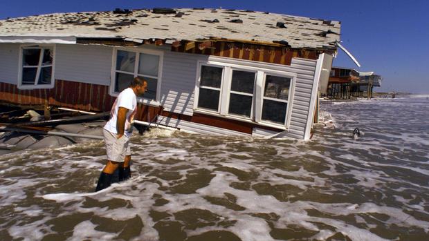
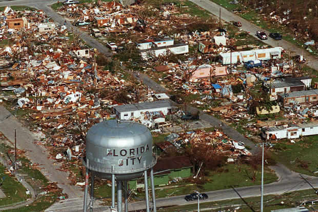
Andrew a quarter century ago was an unusually compact major storm that roared east-to-west almost in a straight line and hit just south of the core of Miami. Months after its August 23, 1992, landfall, meteorologists upgraded it to a Category 5 hurricane with 167 mph winds at one point and 17-foot storm surge in another. The storm killed 65 people, according to the National Hurricane Center's report.
Andrew's hurricane force winds were only about 30 miles wide and so was its swath of utter destruction.
It was like "an incredible buzz saw giant tornado of a hurricane that hit metropolitan Southeast Florida," Norcross said. Yet outside that area damage was minimal, more like a Category 1 storm.
And the place it hit with its massive winds was on the southern tip of Dade County and any place else would have caused far more damage, Norcross and Hale said.
"As bad as it was, it was as good as it could have been," Norcross said.
Andrew's path also took it straight out of South Florida at relatively high speeds of about 18 mph.
The National Hurricane Center's forecast path for Irma is from the south, hitting Miami and perhaps its highly developed and expensive central region, then up through affluent Broward and Palm Beach counties and further north, threatening the entire peninsula instead of just its tip.
For disaster officials trying to rescue people and clean up, that's a big difference.
"Everything north of us was functioning and safe," said Hale, now an emergency manager in Virginia. "This time everything north of them is going to be in bad shape as well."
Andrew intensified to a Category 5 hurricane just before hitting land, while Irma has been a Category 5 storm for days and is forecast to fluctuate in intensity in the next couple days and could hit as a strong Category 4. But forecasts of a weakening storm are somewhat iffy, meteorologists said.
Another huge factor is Andrew was so small, while Irma is already a normal size storm and likely to grow bigger with up to 100 miles wide of Category 5 hurricane force winds, triple Andrew's girth, according to Jeff Masters, meteorology director at the private Weather Underground.
Irma "is going over a much bigger population," Masters said. "Andrew missed like four-fifths of the Miami-Dade population centers."
About 1.9 million people lived in Miami-Dade County when Andrew hit. Now about 6 million people live in South Florida's three counties and another 4 million people live in threatened Orlando and Jacksonville.
More than a half-million people in Miami-Dade County were ordered to leave.
"Take it seriously," said Maj. Jeremy DeHart, a U.S. Air Force Reserve weather officer who flew through the eye of Irma at 10,000 feet. "Because this is the real deal."
Irma's forecast track keeps shifting. Thursday afternoon's track puts Irma's power over Miami and later Jacksonville with the storm directly over Orlando. However the margin of error is still so big it encompasses the entire Florida peninsula.