Philadelphia Weather: Region Could See First 90-Degree Day As Potential Severe Storms Move In Wednesday Afternoon
PHILADELPHIA (CBS) -- Temperatures and humidity levels quickly will skyrocket today, opening the door for strong to severe storms to move into the Philadelphia region Wednesday afternoon. Our first 90-degree day of the season will likely occur this afternoon.
⚠️⚠️ Severe thunderstorms producing damaging winds closing in on Philly and the 95 corridor. Winds to 80 mph possible! Head indoors now. @CBSPhilly pic.twitter.com/1MlT6tg9Oe
— Lauren Casey (@ClimateCasey) June 3, 2020
The atmosphere will be very unstable, prompting prime conditions for an active afternoon and evening.
A cold front will start to push in during the afternoon. The primary threat are damaging winds in the order of 40 to 50 mph, locally higher speeds and gusts are possible.
A slight chance for #severeweather arrives Wednesday for parts of the Northeast. #Damagingwinds are likely. pic.twitter.com/JLJaCIe43S
— Llarisa Abreu (@LlarisaAbreu) June 2, 2020
Timing, at this point, looks like storms will begin between 1 p.m. and 4 p.m., then again between 6 p.m. and 9 p.m.
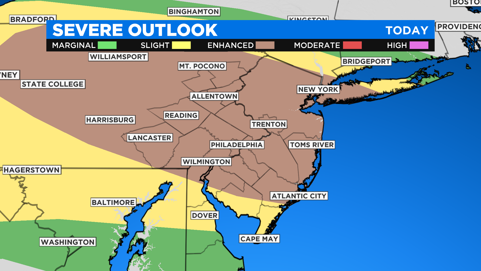
Southeastern Pennsylvania and South Jersey are under an enhanced risk for severe weather.
Download The New And Improved CBS Philly App!
Cape May, southern Cumberland County, and Delaware are under a slight risk of severe weather today and tonight.
Additional threats include downpours, sizable hail, and isolated tornadoes are not out of the question.
The remainder of the week remains unsettled, but as of now, the severe weather threat looks to unfold today.
It appears a frontal boundary will stall over the region on Thursday.
Shower and storm chances will be concentrated closer to Thursday afternoon and evening, which is likely to be south of Philly, but this could shift given its final position.
Humidity returns for all on Friday as the front lifts north again along with a hit-or-miss thunderstorm chance.
Rain and storms are possible on Saturday before a stronger cold front sweeps all the way through and reduces the high heat and humidity by Saturday night.
TROPICS
Tropical Storm Cristobal has formed in the southern Gulf of Mexico. Cristobal is forecast to meander around near its current position over the next several days before making a move north into the open waters of the Gulf of Mexico this weekend.
Slow strengthening is expected.
Cristobal is predicted to pose a threat to the United States Gulf Coast by the end of the weekend and early next week. Cristobal is now the earliest third named storm on record.
The old record was Colin, which formed on June 5, 2016.