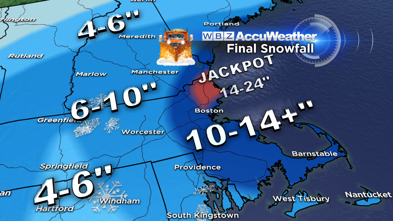
Our latest storm lived up to its advertising in terms of delivering the anticipated fluffy snowfall, cold and wind plus tidal flooding. Boston's official snowfall was 15.1" which makes this storm the 5th snowiest January storm on record which actually shocks me. Although we anticipated ocean-effect banding with the highest snowfall in places on the North Shore and South Shore, the intensity of the snow surpassed expectations during Thursday in a strip across portions of Essex County. That is where the jackpot of 20-25" occurred in places like Ipwsich, Danvers, Topsfield , Rowley and Boxford. The arctic boundary set up shop there early Thursday morning and that was the focus axis of some extra convergence with frigid air flowing in from the north and more moist air in from the east-northeast. The result was a fluff storm reducing visibility at times under a quarter of a mile and yielding a featherweight layer of ivory snow flakes up to two feet deep! After that band decayed at mid-afternoon, only a small amount of fine snow fell through the rest of the night in that area while the second impulse emerging off the North Carolina coast produced the heavier snow over southeastern MA. After the storm departure this morning, ocean-effect streaks of snow caused showers of snow of varying intensity on the outer Cape and the Island into the afternoon hours.
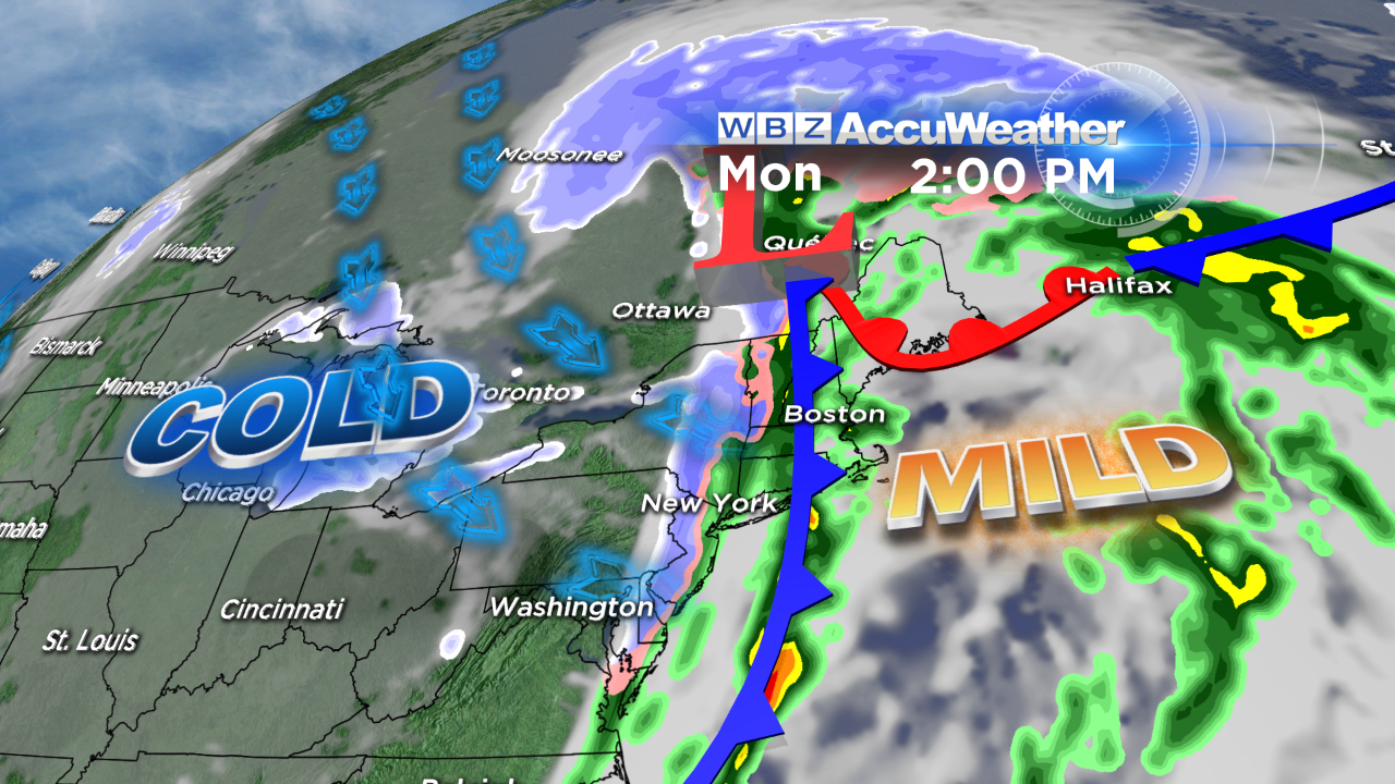
Are you ready for a roller coaster ride? After tonight's arctic chill followed by the weekend warmup to 40 on Sunday, temperatures could spike a dozen degrees higher Monday morning if a developing storm in the Ohio Valley surges across western NY into Ontario and Quebec. If this system intensifies sharply, it could haul up a wedge of 50s into eastern New England. That is what I am counting on to verify my forecast of 53 degrees at 10am to noon on Monday. If the storm is much weaker and tracks a bit farther east, there will be less warm air advection and 40s would be tops. In any event, the storm will have a strong cold front attached to it and this boundary will press eastward and push offshore by late afternoon on Monday. Consequently, it will turn colder from west to east later Monday with very cold air pouring into the region Monday night through Tuesday. Temperatures will plunge into the middle 20s by dawn Tuesday then fall another 10 degrees to the middle to lower teens for the usual afternoon highs around 2pm. After a fall to near or just under 10 degrees Tuesday night, you can expect a recovery to the middle 20s on Wednesday and the lower 30s on Thursday and Friday. There are no more big storms in sight for the time being with only a weak wave projected to release some light snow later next Thursday into Friday morning.
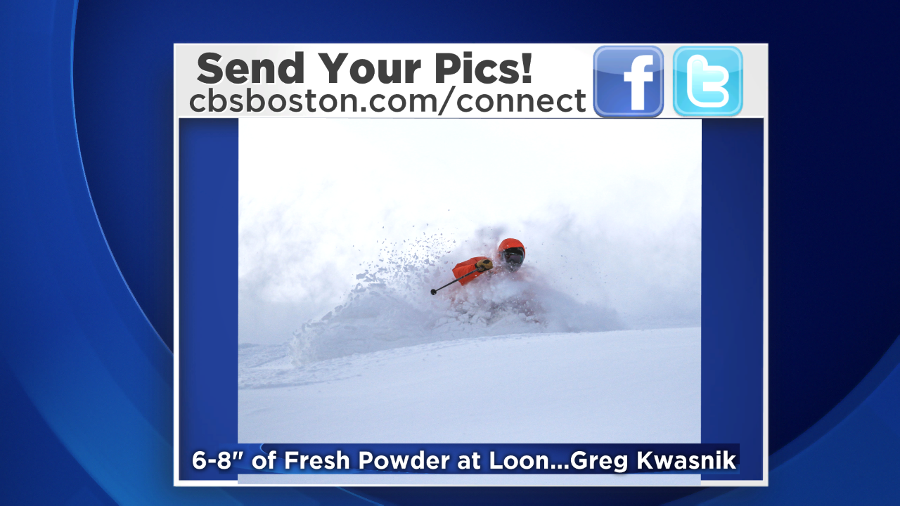
The fresh fluff is a skier's delight and most of the resorts received 6-12" of it which is great but these places all need a gargantuan storm of 2-3 feet to really open up all of the terrain especially all of the glades, the shoots and the non-snowmaking trails. Regardless, there is still a sufficient percentage of slopes open for your pleasure. Most are reporting powder and packed powder conditions which is awesome. Always be prepared for exposed icy and hard-packed patches created by drifting and skier traffic particularly on steeper terrain. In this arctic setup, use hand and toe warmers and dress properly in several layers and wear goggles, warm mittens over gloves, a helmet and even a face mask. Avoid frostbite by covering your skin and taking breaks in the ski lodge. You can have a blast skiing or riding if you're prepared for the conditions. For me, skiing through fresh pow in really cold conditions is my fav time on the mountains! Be safe and courteous on the slopes!
Danielle Niles will post her thought tomorrow morning and I shall return later in the day.
Have a happy and safe weekend.
Read more
More from CBS News
We and our partners use cookies to understand how you use our site, improve your experience and serve you personalized content and advertising. Read about how we use cookies in our cookie policy and how you can control them by clicking Manage Settings. By continuing to use this site, you accept these cookies.