Malaysia's preliminary Flight 370 report sheds little light as official urges check into report of "wreckage"
The Malaysian government released a preliminary report into the disappearance of Malaysia Airlines flight MH370 on Thursday, but the five-page report shed little new light on the mystery of the vanished jet, largely reiterating the sparse information already available, and calling for better tracking of passenger aircraft in the future.
Malaysia's Ministry of Transport concluded in the report, dated April 9, that an analysis of data provided by British satellite company Inmarsat, "indicated that MH 370 flew the southern corridor and ended its flight in the southern part of the Indian Ocean."
The report clarifies the timing of the communications between various air traffic control center and the aircraft, noting that controllers in Vietnam only reported the plane missing 17 minutes after it disappeared from civilian radar. Another detail revealed Thursday was that it took the Malaysian government four hours to launch an official search and rescue operation from the time the plane went missing.
Officials in charge of the joint international investigation remain adamant that the plane could only have crashed into the southern Indian Ocean, given their interpretation of the final seven "pings" sent from the Boeing 777-200 to an Inmarsat satellite.
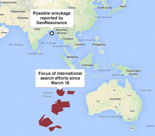
The Australian agency in charge of the Indian Ocean search dismissed on Wednesday a claim by a geological survey company that it had discovered what it believed to be the "wreckage of a commercial airliner" about 100 miles south of Bangladesh in the Bay of Bengal.
GeoResonance Pty Ltd. said in a statement sent Tuesday to CBS News that it had discovered the suspect materials using proprietary technology which scans vast areas for specific metals or minerals. But the location of their discovery is thousands of miles north of the Indian Ocean search area.
According to the Associated Press, Houston said he only learned of GeoResonance's report this week.
"Any sort of information that comes forth needs to be investigated," he told Sky News Australia. "It's certainly something that needs to be looked at and I believe it probably has been looked at, but I'm not aware of any of that detail. I'm focused on the search in our area of responsibility."
GeoResonance said it first alerted officials with Malaysia Airlines and the Chinese and Malaysian embassies in Australia that possible aircraft debris had been found in the general area of its discovery on March 31, "well before the black box batteries had expired."
"These details were also passed on to the Australian authorities (JACC) in Perth on April 4, 2014," the company said. "A more detailed study was completed in early April. The final 23 page report including the precise location of the wreckage was passed onto Malaysian Airlines, Malaysian High Commission in Canberra, Chinese Embassy in Canberra, and the Australian authorities (JACC) on April 15, 2014."
In a statement released to the press on Tuesday, Malaysian Acting Minister of Transport Hishammuddin Hussein confirmed that his government was "working with its international partners to assess the credibility" of the GeoResonance report. It was not clear whether Malaysia had previously looked into the claims.
The preliminary report released by Malaysia on Thursday urged international aviation regulators to "examine the safety benefits of introducing a standard for real time tracking of commercial air transport aircraft."
Mary Kirby, the founder and editor of the aviation news company Runway Girl Network, told CBS News in late March that airlines have already been kicking around ideas on how to take advantage of current technology on passenger jets to feed flight data -- securely and cost effectively -- back to the ground in real time.
But in the longer term, Kirby said the industry must move toward a global, "space-based" air-traffic control network.
A system, she said, "that's satellite-supported that covers the entire globe including the [North and South] poles."
The system is coming soon, Kirby noted, with a network of satellites beginning to launch next year with the capability to "see where every aircraft is in the world." But full roll-out of that new global network Kirby warned, is still a few years away.