Hawaii's Kilauea volcano has experts warily eyeing volcanic peaks along West Coast
SPOKANE, Wash. -- The eruption of Hawaii's Kilauea volcano in the Pacific "Ring of Fire" has experts warily eyeing volcanic peaks on America's West Coast that are also part of the geologically active region. The West Coast is home to an 800-mile chain of 13 volcanoes, from Washington state's Mount Baker to California's Lassen Peak. They include Mount St. Helens, whose spectacular 1980 eruption in the Pacific Northwest killed dozens of people and sent volcanic ash across the country, and massive Mount Rainier, which towers above the Seattle metro area.
"There's lots of anxiety out there," said Liz Westby, geologist at the U.S. Geological Survey Cascades Volcano Observatory in Vancouver, Washington, in the shadow of Mount St. Helens. "They see destruction, and people get nervous."
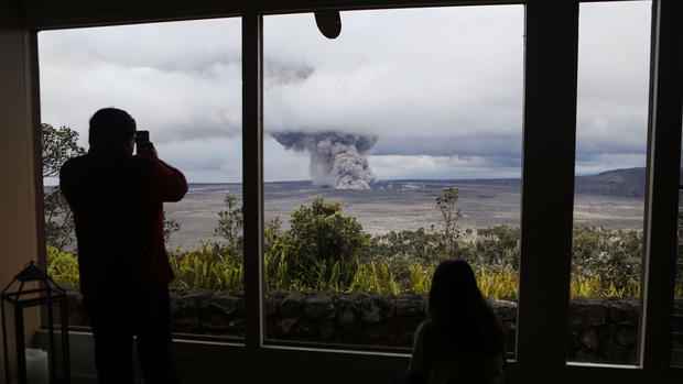
Kilauea, on Hawaii's Big Island, is threatening to blow its top in coming days or weeks after sputtering lava for a week, forcing about 2,000 people to evacuate, destroying two dozen homes and threatening a geothermal plant. Experts fear the volcano could hurl ash and boulders the size of refrigerators miles into the air. On Friday, President Donald Trump declared a major disaster existed on the Big Island -- a move that will make federal financial assistance available to state and local governments as they repair roads, public parks, schools and water pipes damaged by the eruption. It will also help cover costs for geologists and security personnel at roadblocks.
Here are some key things to know:
What is the "Ring of Fire"?
Roughly 450 volcanoes make up a horseshoe-shaped belt with Kilauea situated in the middle. The belt follows the coasts of South America, North America, eastern Asia, Australia and New Zealand. It's known for frequent volcanic and seismic activity caused by the colliding of crustal plates.
America's most dangerous volcanoes are all part of the Ring of Fire, and most are on the West Coast, according to the U.S. Geological Survey. Besides Kilauea, they include: Mount St. Helens and Mount Rainier in Washington; Mount Hood and South Sister in Oregon; and Mount Shasta and Lassen Volcanic Center in California.
Images of lava flowing from the ground and homes going up in flames in Hawaii have stoked unease among residents elsewhere along the Ring of Fire. But experts say an eruption on one section of the arc doesn't necessarily signal danger in other parts.
"These are isolated systems," Westby said.
When will the West Coast volcanoes erupt?
No eruption seems imminent, experts say. The Cascades Volcano Observatory monitors volcanoes in the Pacific Northwest and posts weekly status reports. All currently register "normal."
But the situation can change fast. "All our mountains are considered active and, geologically speaking, things seem to happen in the Northwest about every 100 years," said John Ufford, preparedness manager for the Washington Emergency Management Division. "It's an inexact timeline."
Some geologists believe Mount St. Helens is the most likely to erupt. But six other Cascade volcanoes have been active in the past 300 years, including steam eruptions at Mount Rainier and Glacier Peak and a 1915 blast at Lassen Peak that destroyed nearby ranches.
What kind of damage could they do?
The Big Island scenes of rivers of lava snaking through neighborhoods and sprouting fountains are unlikely in the Pacific Northwest.
"Lava is not the hazard, per se, like in Hawaii," said Ian Lange, a retired University of Montana geology professor. Cascade volcanos produce a thicker, more viscous type of lava than Hawaiian volcanoes, so it doesn't run as far, Lange said.
The Cascade volcanoes can produce huge clouds of choking ash and send deadly mudslides into rivers and streams. Two of the most potentially destructive are Mount St. Helens, north of the Portland, Oregon, metro area, and 14,000-foot Mount Rainier, which is visible from the cities of Seattle and Tacoma.
Mount Rainier eruptions in the distant past have caused destruction as far west as Puget Sound, some 50 miles away. The volcano hasn't produced a significant eruption in the past 500 years. But it remains dangerous because of its great height, frequent earthquakes, active hydrothermal system, and 26 glaciers, experts said.
An eruption on Mount Rainier could rapidly melt glaciers, triggering huge mudflows -- called lahars -- that could reach the densely populated surrounding lowlands, Westby said. Another major danger from a Cascade volcano eruption would be large amounts of ash thrown into the air, where it could foul aircraft engines.
What are communities doing to prepare?
The closest settlement to a West Coast volcano may be Government Camp, on Oregon's Mount Hood. Lava could conceivably reach the town, but the greater threat is an eruption triggering a so-called pyroclastic flow, which is a fast-moving cloud of hot ash and gas, experts said.
Lange, however, believes California's Mount Shasta is the most dangerous, in part because it is surrounded by towns. The town of Mt. Shasta has numerous response plans for emergencies, including a volcano eruption, Police Chief Parish Cross said. But the plan for a volcano is pretty fluid, he said.
"We don't know the size or scope of the event," Cross said, including which direction the eruption would occur.
This is not an issue in Orting, Washington, about 20 miles west of Mount Rainier. Orting would be directly in the path of a lahar, and local officials each year conduct drills in which children move from school to higher ground to escape the flow.
Students usually take about 45 minutes to walk the 2 miles to higher ground, which should be fast enough to escape, officials said.
"Our concern is ice and snow melting rapidly on Mount Rainier," said Chuck Morrison, a resident of the town of 7,600 who has long been involved in evacuation planning. "We need a quick way off the valley floor."
Orting is the town most vulnerable to lahar damage from Mount Rainier, according to the U.S. Geological Survey.
Scientists say that in the worst case, a 30-foot-high lahar with the consistency of wet concrete could rumble through Orting at 50 mph if volcanic activity suddenly melted snow and ice on Rainier.
What damage has Kilauea done so far?
Starting last week, the erupting volcano sent 2,200-degree lava bursting through cracks into people's backyards in the Leilani Estates neighborhood, and as Kilauea's magma shifted underground, a magnitude-6.9 earthquake rocked the Big Island.
There have been frequent aftershocks since the quake. More than a dozen fissures oozing lava have opened in the ground. Adding to the distress, 36 structures were destroyed -- 26 of them homes.
Hawaii County Civil Defense officials have urged residents in lower Puna, a district on the Big Island, to remain vigilant and be ready to evacuate on short notice, CBS Honolulu affiliate KGMB reports. They can also leave voluntarily and stay in one of two shelters at Pahoa and Keaau community centers.
As of Saturday, mandatory evacuations remained in place for Leilani Estates as well as the Lanipuna Gardens subdivision.
"We still have a highly active volcano here at Kilauea," says Tina Neal, USGS scientist-in-charge at the Hawaiian Volcano Observatory. "The situation remains unstable. Additional outbreaks of lava are likely." She also said fears are growing that "hotter, fresher" magma could be making its way downslope.