Ida's Impact: Cleanup Underway After Remnants Of Storm Cause Widespread Flooding, Damage
By: KDKA-TV News Staff
PITTSBURGH (KDKA) -- Hurricane Ida made landfall on Sunday morning as a major Category 4 hurricane, bringing heavy winds, rain, storm surge, and flooding to the Gulf Coast. It has since been downgraded to a Tropical Depression and its remnants pushed through Western Pennsylvania Tuesday night and through Wednesday.
As Ida moves inland, stay with the KDKA Weather Team as we continue to monitor developments on how the storm could impact our area locally.
SCHOOL DELAYS & CLOSURES:
Flooding and heavy damage have prompted delays, closures and dismissals. Stay up to date on the list at KDKA.com/closings.
Thursday Updates
4:21 p.m. -- The Pittsburgh Parking Authority says the Mon Wharf will reopen on Friday.
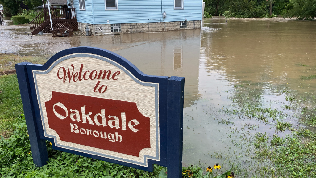
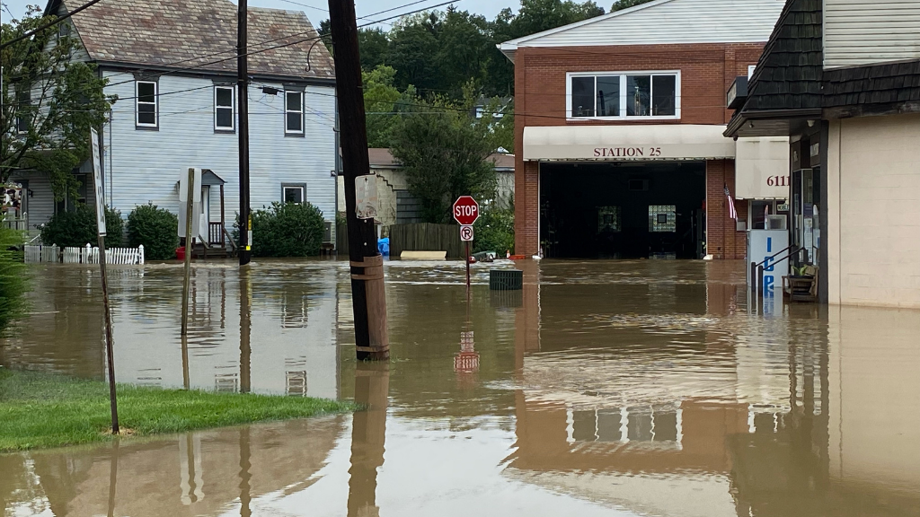
2:20 p.m. -- One of the hardest hit areas on Wednesday was Oakdale. Cleanup is underway there. Some businesses owners were flooded from Ida and were closed Thursday. Those on Noblestown Road found their properties several feet underwater.
A line marking the side of Sil's Market shows how high water rose, destroying the basement. Just a few steps away, Our Cars Auto Detailing had more than 2 feet in the shop. Click here to read the full story.
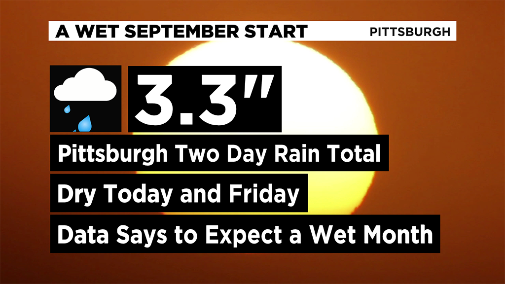
12:50 p.m. -- The two-day total of rain at the Pittsburgh International Airport was 3.3 inches. That's also the normal monthly total of rain for September in Pittsburgh. Wednesday saw 2.31 inches of rain, a whopping 70 percent of the monthly normal rainfall that we see in September. Read more here.
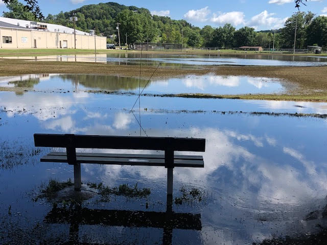
11:50 a.m. -- Check out our photo gallery to survey the damage and flooding from across the region.
This is a new photo Thursday from Greensburg, Westmoreland County. Lynch Field is a flooded mess from the rain.
Wednesday Updates
7 p.m. -- Allegheny County officials report no deaths or injuries from the remnants of Ida. Click here to read more about what county leaders have to say about the next 36 hours.
6:03 p.m. - Until a little while ago, there was two feet of water in the streets in Oakdale. Earlier this morning, people say there was four feet.
It left a lot of mud and debris, but firefighters from the Oakdale Volunteer Fire Department made quick work of that.
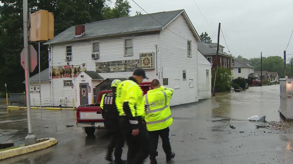
5:22 p.m. -- A look at the mess left behind in South Park and Bridgeville.
Bridgeville: "Do you want to go, and I said, no. If it gets worse, call 911 and we'll send a boat," Lynn St. Clair said about being asked to evacuate in Bridgeville. "After every flood, I keep less there, than I did before. Every time it floods, just throw it all away because it's gone."
South Park: "We have the water rescue team out of Jefferson Hills making their way down the roadway checking homes one at a time and evacuating residents the best we can," said Jeff Guerriero, the Library Volunteer Fire Company Chief.
3:41 p.m. - Washington County hazmat has been called after a tank filled with home heating oil spilled into Raccoon Creek after Ida's wrath. Click here for more.
3:00 p.m. - Due to flooded roadways across the area, many roads have been shut down until the water recedes. Click here for a full list of closures.
2:44 p.m. - Allegheny County Executive Rich Fitzgerald, Emergency Services Chief Matt Brown and Public Works Director Stephen Shanle held a press conference.
They said while it appears that the worst of the rain is over, we're not out of the woods. They urged people to continue to use caution.
According to officials, Bridgeville, Scott Township and Millvale are under a state of emergency.
1:37 p.m. -- In Burgettstown, numerous areas were flooded.
Just some of the #Ida aftermath in Burgettstown. pic.twitter.com/7Y5Jdw5eAj
— Amy Wadas (@AmyWadas) September 1, 2021
1:21 p.m. - Flood Warnings have been issued for multiple counties in our area.
One Flood Warning has been issued for parts of east-central Westmoreland and Indiana counties. That's in effect until 4:15 p.m.
Another was issued for central Fayette, Westmoreland and southwestern Indiana counties until 4:15 p.m.
Meanwhile, one covering southeastern Fayette County, as well as parts of Preston, Tucker and Monongalia counties in West Virginia has been extended until 4:15 p.m.
1:00 p.m. - A shed in Avella was washed away by rising flood waters.
WASHED AWAY: A shed was lifted up and carried away by flood waters in Avella as the remnants of Hurricane Ida moved across Western Pa. this morning.
— KDKA (@KDKA) September 1, 2021
The latest on Ida's impact on our region: https://t.co/GA9vpl3y5G pic.twitter.com/dZ616aHbDI
12:46 p.m. - Parts of Houston, Pennsylvania were heavily flooded. Video captured by KDKA's Amy Wadas shows a lone tire floating through high water on West Pike and Western.
A lone tire floats through Houston, PA.
— Amy Wadas (@AmyWadas) September 1, 2021
This is West Pike and Western. @KDKA pic.twitter.com/MM2ArkD6pb
12:45 p.m. - With the remnants of Ida moving through the area, All eyes are along the Monongahela and the Youghiogheny rivers for the next 24 to 36 hours, waiting to see how much they may or may not rise and/or flood. Read more.
12:37 p.m. - A state of emergency has been declared in Scott Township.
The President and Vice President of the Board in Scott Township have declared a state of emergency.
— Allegheny County (@Allegheny_Co) September 1, 2021
12:14 p.m. - Crews in Shaler are hard at work, doing all they can to pump water out of homes that are dealing with flooding.
Pumps on pumps on pumps! It's a team effort in Shaler to get all the water of these residents homes. Shout out to the volunteer firefighters lining up to assist. @KDKA pic.twitter.com/h8lmXIYjko
— Nicole Ford (@NicoleFordTV) September 1, 2021
11:31 a.m. - With the remnants of Hurricane Ida causing rivers, creeks, ponds and streams to rise to dangerous levels, several roads have been shut down. Click here for a list.
11:27 a.m. - Gov. Tom Wolf, PEMA, PennDOT and State Police held a press conference to provide an update on the state's response to the heavy rain and significant flooding.
"This is an extremely dangerous storm that is impacting the entire state. As we continue to monitor the conditions, I ask everyone to please stay home if you're able," Gov. Wolf said. "If you must travel, please monitor the latest road conditions and weather updates. Please, I urge everyone to take this storm seriously and stay safe."
PEMA Director Randy Padfield said water rescue teams have been dispatched from parts of the state that will see less flooding to areas where more significant impacts are expected.
If you do need to drive, officials reiterated this statement: "turn around, don't drown."
9:28 a.m. - A Flash Flood Warning has been issued for parts of Allegheny, Fayette, Greene, Washington, Westmoreland, Armstrong, and Indiana counties until 3:30 p.m.
Flash Flood Warning including West Mifflin PA, McKeesport PA, Greensburg PA until 3:30 PM EDT pic.twitter.com/BmZFGLw9Yu
— NWS Pittsburgh (@NWSPittsburgh) September 1, 2021
9:00 a.m. PennDOT has updated its list of closed roads due to flooding and downed utilities as of 9:00 a.m.
- Little Pine Creek Road in Shaler Township is closed between Wetzel Road and Marzolf Road due to downed trees and utilities.
- Piney Fork Road in South Park Township is closed between Connor Road and Snowden Road due to flooding.
- Route 50 in Carnegie Borough from Franklin Avenue to Hope Street in Scott Township is closed due to flooding.
- Streets Run Road in Baldwin Borough is closed between Brentwood Road and the City of Pittsburgh due to flooding.
- Route 48 in White Oak is closed at the intersection of Ripple Road due to flooding.
- Route 51 (Saw Mill Run Boulevard) is closed between Bausman Street and Whited Street in the City of Pittsburgh due to flooding.
- Seavy Road is closed at the intersection of Elbie Road in Shaler Township due to flooding.
- Freeport Road is closed between Boyd Avenue and Clifton Avenue in O'Hara Township due to flooding
- Presto Sygan Road is closed between Thoms Run Road in Collier Township and Newbury Highland in South Fayette Township due to a downed tree.
- Saxonburg Boulevard is closed at the intersection of McClure Road in West Deer Township due to flooding.
- McLaughlin Run Road is closed between Bower Hill Road in Bridgeville Borough and Route 19 in Upper St. Clair due to mudslides and debris on the roads.
- Mayview Road is closed between Boyce Road and Willowbrook Road in South Fayette Township due to flooding.
8:48 a.m. - The Pittsburgh Zoo and PPG Aquarium announced that due to the flooding and rain in the area, they will be closed to visitors on Wednesday.
8:45 a.m. - As of 8:45 a.m., Church and Pleasant streets in South Park Township have reopened as the water has since receded.
According to the Library Fire Chief, two homes were evacuated, with four adults and three children in total being evacuated.
Church and Pleasant Streets are back open since water receded.
— Briana Smith (@brianasmithnews) September 1, 2021
The Library Fire Chief says 2 homes were evacuated — 4 adults and 3 children.
One house had up to 6 ft. of water in the basement. @KDKA pic.twitter.com/T3vWFNTUH9
8:40 a.m. - A lane restriction is in place on McClelland Road in North Strabane Township due to a mudslide.
The fire chief tells KDKA the concern right now is a telephone pole that has tipped over and that it could fall onto the road.
West Penn Power and PennDOT have been notified.
NOW: The North Strabane fire chief says they're dealing with a mudslide on McClelland Road. I'm told there is now a lane restriction & as you can see, the concern here is the telephone pole tipping over. The fire chief says @PennDOTNews & West Penn Power has been notified. pic.twitter.com/3eJXR8fFIq
— Amy Wadas (@AmyWadas) September 1, 2021
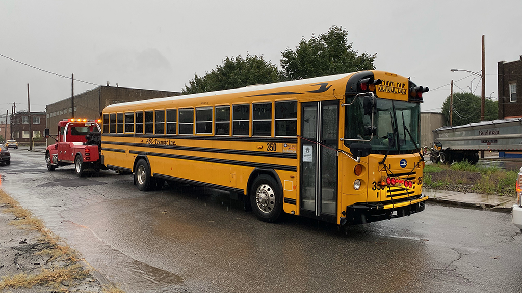
8:30 a.m. - In McKees Rocks on Graham Street between Helen and George Streets, a school bus attempted to drive through flood waters and stalled out.
Municipal employees were able to get everyone off the bus and a tow truck was able to remove the bus from the waters.
No injuries were reported.
8:19 a.m. - Due to flooding, Mayor Copeland has declared a disaster emergency in the borough.
Bridgeville: Mayor Copeland has declared a disaster emergency in the borough
— Allegheny County (@Allegheny_Co) September 1, 2021
Chris Hoffman will have more on the situation in Bridgeville on Pittsburgh's CW and CBSN Pittsburgh as more information becomes available.
8:10 a.m. - 40 students were removed from a school bus stuck on Seavy Road in Shaler Township after the bus became stuck in flood waters.
According to the Shaler Township Police Chief, no injuries were reported and the students were safely transported to school.
Shaler Area School has closed Kindergarten-6th grade today.
Meanwhile, middle school and high school are open and in session.
7:45 a.m. - In South Park Township, homes are being evacuated along Church Street due to flooding from Peters Creek.
The Port Authority has also closed the Library Silver Line as the tracks have been flooded.
SOUTH PARK FLOODING: Church and Pleasant Streets are blocked off because Peters Creek overflowed and flooded this area.
— Briana Smith (@brianasmithnews) September 1, 2021
The Port Authority Library Silver Line is closed.
Water rescue crews are evacuating 6-7 homes on Church Street.
Stay with @KDKA. pic.twitter.com/fNFOuSfk2F
7:30 a.m. - Several roads are shut down due to flooding and downed trees or wires.
Babcock Boulevard is closed from People's Plank to McKnight Road, Thompson Run Road is closed from Vilsack to Babcock Boulevard, and Union Avenue from 279 is closed.
7:15 a.m. - As flooding worsens in Bridgeville, the fire chief has told those in McLaughlin or Maple to evacuate.
BREAKING: Bridgeville fire chief says if you are in McLaughlin or Maple in Bridgeville, it's time to evacuate. @KDKA
— Chris Hoffman (@NewsmanChris) September 1, 2021
McLaughlin Run in Bridgeville is almost up against the bridge near McLaughlin Run Road. @KDKA pic.twitter.com/28MwQt8rKx
— Chris Hoffman (@NewsmanChris) September 1, 2021
7:10 a.m. - Pittsburgh Public Safety has activated the flood gates along Washington Boulevard.
Water has been rising steadily along Glass Run Road.
They are asking drivers to choose alternate routes.
The flood gates have been activated along Washington Blvd. and water is rising steadily along Glass Run Road.
— Pittsburgh Public Safety (@PghPublicSafety) September 1, 2021
If driving cannot be avoided, please choose alternate routes in those areas that are susceptible to flooding. https://t.co/r9Zw38ZWA4
6:50 a.m. - A portion of Route 51 is shut down and it appears a water rescue is underway due to flooding.
The flooding occurred near Bausman Street.
According to Pittsburgh Public Safety, "numerous" water rescues are being conducted.
They are warning motorists to heed all flood barriers and avoid driving through rising waters.
6:30 a.m. - PennDOT has announced the closure of several roads in Allegheny County due to flooding or downed trees and utilities.
- Little Pine Creek Road in Shaler Township is closed between Wetzel Road and Marzolf Road due to downed trees and utilities.
- Piney Fork Road in South Park Township is closed between Connor Road and Snowden Road due to flooding.
- Route 50 in Carnegie Borough from Franklin Avenue to Hope Street in Scott Township is closed due to flooding.
- Streets Run Road in Baldwin Borough is closed between Brentwood Road and the City of Pittsburgh due to flooding.
- Route 48 in White Oak is closed at the intersection of Ripple Road due to flooding.
6:24 a.m. - A Flash Flood warning is in effect for several counties in our area.
Flash Flood Warning including Pittsburgh PA, Bethel Park PA, Monroeville PA until 12:15 PM EDT pic.twitter.com/JR1mTFkrFC
— NWS Pittsburgh (@NWSPittsburgh) September 1, 2021
The warning is in place until 12:15 p.m.
6:20 a.m. - As we continue to track the rain, the area has watches and warnings.
KDKA's Mary Ours brought live updates on Facebook Live.
5:45 a.m. - Due to flooding, Valley Brook Road is closed.
The creek along the road has risen to nearly even with the street.
This is how high the creek along Valley Brook Road and East McMurray Road is flowing in Peters Township. It's not too far from running even with the street. @KDKA pic.twitter.com/O8FDc42cm1
— Chris Hoffman (@NewsmanChris) September 1, 2021
5:30 a.m. - As the South Hills wakes up to heavy rain and even some flooding, Andy Amreihn has been up since 3:00 a.m. preparing the Every True Value hardware store for those who need supplies to respond to the flooding.
"People know that I get here early, I'm a morning person, so they wanted the first chance of getting the pumps, and the carpet extractors, carpet dryers, squeegees, mops, everything they need to keep ahead of the raging water let's say," he said. "Part of our area, close to South Park, to the end of Bethel, and our Piney Fork watershed area, it's been known to flood and it did."
WATCH: Interview with Andy Amreihn
5:15 a.m. - According to PennDOT, they're already beginning to see issues in southern Allegheny County.
WATCH: Interview with PennDOT's Lori Musto
"They're seeing the creek levels rise, they're also seeing water run across the road," said PennDOT's Lori Musto. "The ground is so saturated, it's coming off the hillside and places we don't normally see it. They are seeing the creek levels rise."
5:05 a.m. - An Areal Flood Advisory has been issued for most of the area, including the Pittsburgh metro area as of 5:05 a.m. It will remain in place until 7:00 a.m. Wednesday morning.
The National Weather Service says areas that could experience flooding include:
- Pittsburgh
- Penn Hills
- Mt. Lebanon
- Bethel Park
- Ross Township
- McCandless Township
- Monroeville
- Moon Township
- McMurray
- Greensburg
- McKeesport
- Washington
- Franklin Park
- Jeannette
- Canonsburg
Rainfall of about 1 inch could result in minor flooding.
4:50 a.m. - One of the harder-hit areas by the heavy rains was Finleyville.
As Chris Hoffman captured, flooding and rushing water could be found at the corner of Aber Road and Lobbs Run Road.
This is the corner of Aber Road and Lobbs Run Road just outside of Finleyville @KDKA pic.twitter.com/6piGhNWRfY
— Chris Hoffman (@NewsmanChris) September 1, 2021
4:11 a.m. - As of 4:10 a.m., as KDKA's Chris Hoffman tracks the rain and road conditions in the Mobile Weather Lab, so far, roads are just wet. No washouts or flooding.
Here is what we are seeing on the roads. Right now most are just wet. Have seen some ponding, but so far haven't seen any roads covered or washed out. This was near Curry Hollow Road and Brownsville Road. @KDKA pic.twitter.com/W3jgQ4vPDm
— Chris Hoffman (@NewsmanChris) September 1, 2021
3:55 a.m. - There is one active flood warning on Wednesday morning and it's for the Youghiogheny River.
Ron Smiley says there hasn't been much movement from the river but that could change as we get into the afternoon.
We have one active flood warning this morning and it is for the Youghiogheny at the Confluence. Haven't seen too much movement from the river yet but it is expected to begin as we head into the afternoon. #YDP #KDKAwx pic.twitter.com/mNta1iDBzc
— Ron Smiley ???? (@RonSmileyWx) September 1, 2021
2:18 a.m. - Steady rain will roll in as the "core" of what was Hurricane Ida continues to move east along a station boundary that is guiding it.
This rain will continue throughout the morning through a big portion of the afternoon.
Ida UpdateJust a quick early morning update on what is going on with the weather.
Posted by KDKA-TV | CBS Pittsburgh on Tuesday, August 31, 2021
If you have pictures or videos you'd like to share of rain and flooding in your area, you can send them to us at newsdesk@kdka.com or submit them through this link.
Tuesday Updates
10:11 p.m. - After heavy rain throughout the area, the rains from Ida have a chance to trigger flash flooding throughout the area on Wednesday.
After some heavy rain today, this is now how much rain we would need in one and six hours to trigger Flash Flooding. It isn't much, considering #Ida is moving in. If you come across a water covered roadway PLEASE find a safer route! @KDKA pic.twitter.com/XN3pCDLzBV
— Ray Petelin (@RayPetelinWx) September 1, 2021
9:06 p.m. - Governor Tom Wolf signed a proclamation of disaster emergency ahead of the remnants of Hurricane Ida reaching the state.
"This dangerous storm continues to have devastating impacts across the South and as it heads toward Pennsylvania, we are expecting significant rainfall across the state. This proclamation will allow for our emergency preparedness teams to provide any support needed throughout the storm and its aftermath," Gov. Wolf said in a release. "I urge Pennsylvanians to monitor local weather and traffic conditions before making any plans and prepare for potential flooding."
Click here for more.
8:30 p.m. - West Virginia's governor declared a state of emergency in all 55 counties Tuesday due to the threat of flash flooding from Hurricane Ida's remnants. Click here to read more.
7:35 p.m. - There's heavy flooding in the area of Finleyville and Union Township. A creek spilling over its banks surrounded a home. KDKA's Ross Guidotti reports that traffic coming off Route 43 north or south is cut off and you should avoid the Finleyville area.
Finleyville, Union Township area. pic.twitter.com/2BCil1sqDm
— Ross Guidotti (@RossGuidotti) August 31, 2021
5 p.m. -- About 120 Pennsylvania National Guard members have been placed on active duty and are on stand-by as the remnants of Ida move toward the state. The members and 35 high-water capable vehicles are staged at several locations.
4 p.m. -- KDKA Meteorologist Kristin Emery says the first heavy bands of Ida's remnant rain will start arriving from 7 p.m. on. They will push north from Northern West Virginia and through Southwestern Pennsylvania up to the northeast.
Here is her timeline for the rainfall.
Click here for the full story and forecast.
3:20 p.m. -- The Pittsburgh Public Parking Authority is shutting down the Mon Wharf. The parking lot will be closed starting Wednesday until further notice.
5:45 a.m. - KDKA's Chris Hoffman reports live from the North Shore.
4:10 a.m. - The remnants of Ida are moving across north Alabama and Mississippi, Tennessee, and Kentucky, moving closer to our area.
Here's a 4a look at the remnants of Ida. Overall timing of rain will be faster than what it looked like yesterday with rain beginning as early as this morning for many in the watch area. Expected rain totals also have come down a little. Details on KDKA. #YDP #KDKAwx pic.twitter.com/QpR0gc0eT2
— Ron Smiley ???? (@RonSmileyWx) August 31, 2021
Monday Updates
6:07 p.m. - Two deaths have been attributed to the storm. Read more.
5:20 p.m. - KDKA Meteorologist Ray Petelin says right now the heaviest of the rain is timing to begin just before Wednesday morning's commute, with the steadiest of the heavy rain lasting into the afternoon. After that, waves of rain -- some heavy -- will remain possible.
Early model estimates show that rain amounts, especially south of Pittsburgh, could accumulate 3-5" or more. While the placement and intensity can change, there is high confidence that areas south of Pittsburgh will get heavy rainfall.
4:49 p.m. - Ida has been downgraded to a Tropical Depression.
10:24 a.m. - Rainfall totals for the week in the southern parts of our area could reach 6" or more.
Projected rainfall totals for this week... @KDKA pic.twitter.com/ZNGQO5wxqO
— Kristin Emery (@KristinEmery) August 30, 2021
5:41 a.m. - The National Weather Service says that 2-4" of rain are expected to arrive in the area between Tuesday night and Wednesday, with chances for more than that in some areas.
Heavy rainfall associated with the remnants of Hurricane Ida is expected Tuesday night into Wednesday. As a result, a flash flood watch has been issued for the area most likely to receive the highest rain. Amounts of 2 to 4 inches are expected, with locally higher amounts. pic.twitter.com/ucC0bV7jnk
— NWS Pittsburgh (@NWSPittsburgh) August 30, 2021
5:06 a.m. - Hurricane Ida has been downgraded to a Tropical Storm.
4:33 a.m. - The National Weather Service has issued flash flood watch for most of Western Pennsylvania, in effect from late Tuesday night through late Wednesday night.
A FLASH FLOOD WATCH is in effect for areas shaded in green. In W. Pennsylvania, 3"-5" of rain should be expected with some potentially seeing more than 6" of rain. for local impact and preps head to https://t.co/L6u4atCd4m #KDKAwx #YDP pic.twitter.com/TcY4FKul0Y
— Ron Smiley ???? (@RonSmileyWx) August 30, 2021
Sunday Updates
10:21 p.m. - Widespread flooding could occur throughout the Pittsburgh area starting Tuesday and stretching into Wednesday.
Convection from regular thunderstorms and the remnants of Hurricane Ida are going to cause widespread flooding concerns in portions of our region Tuesday into Wednesday. Stay tuned for further information. pic.twitter.com/HKOlmaaD9F
— NWS Pittsburgh (@NWSPittsburgh) August 30, 2021
8:44 p.m. - All power in New Orleans has been reported to be out due to "catastrophic transmission damage."
#BREAKING NEWS: New Orleans is reporting no power due to "catastrophic transmission damage." https://t.co/bfZH5U262u
— KDKA (@KDKA) August 30, 2021
3:28 p.m. - The remnants of Ida are expecting to have an impact here in Western Pennsylvania on Wednesday.
Wednesday could come with heavy rain, as #Ida's remnants pass through our area. This image is for Wednesdays rain only (preliminary info). Many of the models shown on messenger TV are an accumulation of rain starting now through Thursday. #Pittsburgh pic.twitter.com/5M3shM5AbW
— Ray Petelin (@RayPetelinWx) August 29, 2021
12:55 p.m. - The storm made landfall just before 12:00 p.m. CDT at Port Fourchon as a Category 4 hurricane with 145 mph winds.
#HurricaneIda will be making landfall this afternoon as a major Cat 4 hurricane, just shy of a Cat 5. Praying for everyone in its path who couldn't get out in time. The latest at https://t.co/cMkp5pWO2Q ???? @KDKA pic.twitter.com/LHxYbtWjc2
— Mary Ours (@MaryOursWX) August 29, 2021
12:10 a.m. - Early on Sunday, the eye of Hurricane Ida moved closer towards the Gulf Coast, with landfall being expected by morning.
The eye of #Hurricane #Ida is now close enough to #Lousiana to be picked up by radar. Sunday will become drastically worse, as the day wears on there.
— Ray Petelin (@RayPetelinWx) August 29, 2021
First Image=Radar
Second Image= Infrared Satellite pic.twitter.com/DY1Ghd5Qzz
Stay with the KDKA Weather Team and CBS News for the latest developments on Hurricane Ida.
WEATHER LINKS:
Current Conditions | School Delays & Closings | Local Radar | Weather App | Photos
Stay up to date with the KDKA app, which you can download here.