Pittsburgh Weather: Winter Weather Advisory Issued With Accumulating Snowfall On The Way
PITTSBURGH (KDKA) -- The first accumulating snowfall of the season is on the way.
The National Weather Service has issued a Winter Weather Advisory for Greene and Westmoreland counties and the Fayette and Westmoreland ridges. It goes into effect Thursday at 3 p.m. through 9 a.m. Friday. Portions of northern West Virginia are also under the advisory.
Both a Winter Storm Warning and Winter Weather Advisory have been issued for portions of our area in, which can be seen below in pink and purple, respectively.
— NWS Pittsburgh (@NWSPittsburgh) January 5, 2022
The majority of snow will occur on Thurs night, but should taper off for the most part before the AM commute Friday. pic.twitter.com/dT3PV2osvH
The heaviest snow will fall in the highest elevations of West Virginia, the NWS said.
For that reason, parts of Preston and Tucker counties are under a Winter Storm Warning during that same time period.
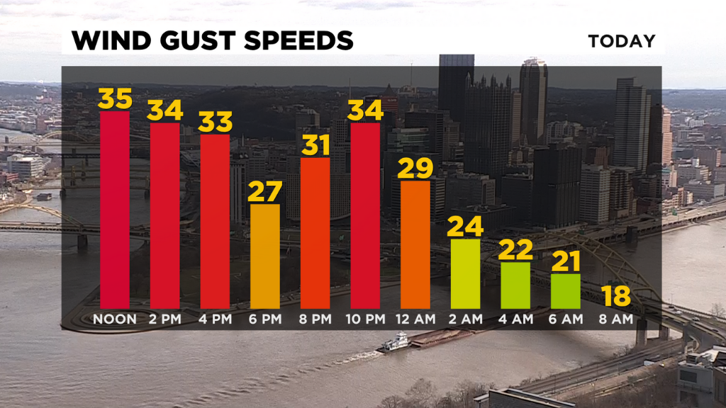
Today, temperatures are well above normal, but it's very windy with gusts around 35mph. Thursday morning, we stay mostly cloudy and drop down to the low 20s and upper teens for some.
Much of Thursday will be dry until snow arrives.
Areas east, and ridges like Seven Springs, could pick up 2-4 inches of snow, which will make ski lovers happy. The rest of us will pick up about an inch overnight Thursday into Friday morning.
This weather maker will roll in between 4-8 p.m. on Thursday.
WEATHER LINKS:
Current Conditions | School Delays & Closings | Local Radar | Weather App | Photos
Temperatures WILL be below freezing all day Thursday and Friday, so icy roads are likely, especially bridges and overpasses and any untreated surfaces.
Stay weather aware.
Thankfully, sunshine returns Saturday.
Stay up to date with the KDKA app, which you can download here.