Weather: Potential For A Flurry Or Two Near Philadelphia
By Geoff Bansen
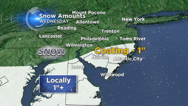
PHILADELPHIA (CBS) -- ***A WINTER WEATHER ADVISORY is in effect for Kent and Sussex Counties in DE and Cape May County in NJ until 1PM***
Parts of Delaware and southern New Jersey are experiencing some snow and some mixed precipitation this morning. Fortunately, this is a mainly isolated storm that will soon begin moving out to sea. When all is said and done, the aforementioned areas could pick up anywhere from a coating of snow to a little over an inch.
For Philadelphia and areas north, it will remain a generally cloudy, chilly day. Places on the northern fringe of the storm could see a flurry, but otherwise will remain dry. Temperatures will top out around the freezing mark.
As the temperatures drop back down this evening, areas that receive precipitation today will need to be careful of re-freezing. Roadways could become icy, so drivers beware!
Thursday, Friday and Saturday all look tranquil, with an increase on the thermometer each day. The first half of the weekend will feel somewhat nice. Sunday should begin dry, but a coastal issue could dump some rain by later in the day.