'Extremely Dangerous' Hurricane Dorian Continued Moving Closer To The Bahamas
MIAMI (CBSMiami) - Hurricane Dorian, a powerful Category 4 hurricane, continues to head for the northwestern Bahamas with life-threatening storm surge and devastating winds.
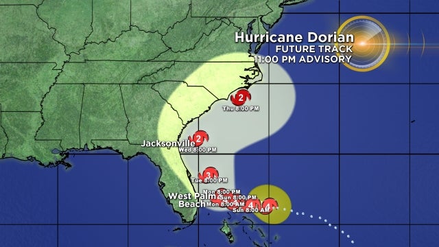
At 11 p.m., the National Hurricane Center called the storm an 'extremely dangerous' storm in its advisory, the center of the storm was about 125 miles east of Great Abaco in the Bahamas and about 310 miles east of West Palm Beach.
Maximum sustained winds remain at 150 mph and it is moving slowly to the west at 8 mph.
Hurricane-force winds extend outward up to 30 miles from the center and tropical-storm-force winds extend outward up to 105 miles.
A Tropical Storm Watch is in effect for Deerfield Beach to Sebastian Inlet.
Dorian is forecast to continue a slower westward motion into early next week. On this track, the core of Dorian should move over the Atlantic well north of the southeastern and central Bahamas Saturday, be near or over the northwestern Bahamas on Sunday, and move near the Florida east coast late Monday through Tuesday.
Some fluctuations in intensity are likely, but Dorian is expected to remain a powerful hurricane during the next few days.
SUMMARY OF WATCHES AND WARNINGS IN EFFECT:
A Hurricane Warning is in effect for...
* Northwestern Bahamas excluding Andros Island
A Hurricane Watch is in effect for...
* Andros Island
A Tropical Storm Watch is in effect for...
* Deerfield Beach to Sebastian Inlet
Hurricane conditions are expected in the hurricane warning area in the northwestern Bahamas by Sunday, with tropical storm winds beginning tonight.
A life-threatening storm surge will raise water levels by as much as 10 to 15 feet above normal tide levels in areas of onshore winds in the northwestern Bahamas. Near the coast, the surge will be accompanied by large and destructive waves.
Dorian is expected to produce the following rainfall accumulations this weekend into the middle of next week:
Northwestern Bahamas - 10 to 15 inches, isolated 25 inches.
Coastal sections of the southeast United States - 4 to 9 inches, isolated 12 inches.
Central Bahamas - 2 to 4 inches, isolated 6 inches.
This rainfall may cause life-threatening flash floods.
Swells will begin affect the east-facing shores of the Bahamas, the Florida east coast, and the southeastern United States coast during the next few days. These swells are likely to cause life-threatening surf and rip current conditions.
- Click here to prepare yourself for an impending storm
- Click here for latest news surrounding hurricanes and the National Hurricane Center
- Click here to see all of the latest maps when a storm forms in the Atlantic
- Click here to download the CBS4 2019 Hurricane Guide (English)
- Click here to download the CBS4 2019 Hurricane Guide (Spanish)
- Download the CBS4 Weather App Here