Watch CBS News

Mars Rover to drill rocks that once held water

Mars Rover Curiosity will soon begin what NASA officials call "the mission's most challenging activity since the landing" as the 2-ton robot prepares to drill into Martian soil for the first time.

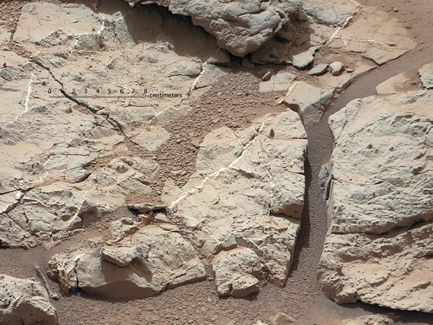
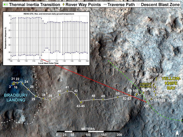
The Mars Science Laboratory team has identified an area of Mars with a highly diverse set of rocks as their first test bed for the untried drill. Of particular interest to the NASA team is the abundant evidence that the rocks -- located in a low-lying depression of bedrock known as Yellow Knife Bay -- once held water.

"The furthest thing we drove to is the jackpot unit," MSL project scientist John Grotzinger told reporters at a press conference on Tuesday. He went on the describe the different types of rock formations that intrigue the NASA team. Many of the rocks are cracked and feature veins of carbon sulfate. The team's belief is that the carbon sulfate most likely accumulated in the cracks because of water.

"These veins are likely composed of hydrated calcium sulfate, such as bassinite or gypsum," said ChemCam team member Nicolas Mangold of the Laboratoire de Planetologie et Geodynamique de Nantes in France. "On Earth, forming veins like these requires water circulating in fractures."

"Basically, these rocks were saturated with water," Grotzinger said.

This image of an outcrop at the "Sheepbed" locality, taken by NASA's Curiosity Mars rover with its right Mast Camera (Mastcam), shows show well-defined veins filled with whitish minerals, interpreted as calcium sulfate.  These veins form when water circulates through fractures, depositing minerals along the sides of the fracture, to form a vein. These veins are Curiosity's first look at minerals that formed within water that percolated within a subsurface environment. These vein fills are characteristic of the stratigraphically lowest unit in the "Yellowknife Bay" area -- known as the Sheepbed Unit.  Mastcam obtained these images the 126th Martian day, or sol, of Curiosity's mission on Mars (Dec. 13, 2012). The view covers an area about 16 inches (40 centimeters) across. A superimposed scale bar is 8 centimeters (3.15 inch) long.
A close up of veined rocks, taken on Dec. 10, 2012, show what NASA believes to be carbon sulfate, a mineral that requires water to form. NASA/JPL-Caltech

The area of Yellowknife Bay could hold the most significant discoveries since Curiosity landed on the red planet five months ago. The diversity of rocks will keep the NASA team busy, but they will also try to determine why exactly Yellowknife Bay is so different from previous areas Curiosity has explored.

"It's like we entered a whole different world," Grotzinger said, comparing the region to Curiosity's landing spot.

"This is a great example of the occurrence of serendipity in scientific discovery." Grotzinger added, pointing out that NASA "wouldn't have predicted any of this from orbit."

This image maps the traverse of NASA's Mars rover Curiosity from "Bradbury Landing" to "Yellowknife Bay," with an inset documenting a change in the ground's thermal properties with arrival at a different type of terrain.  Between Sol (Martian day) 120 and Sol 121 of the mission on Mars (Dec. 7 and Dec. 8, 2012), Curiosity crossed over a terrain boundary into lighter-toned rocks that correspond to high thermal inertia values observed by NASA's Mars Odyssey orbiter. The green dashed line marks the boundary between the terrain types. The inset graphs the range in ground temperature recorded each day by the Rover Environmental Monitoring Station (REMS) on Curiosity. Note that the arrival onto the lighter-toned terrain corresponds with an abrupt shift in the range of daily ground temperatures to a consistently smaller spread in values. This independently signals the same transition seen from orbit, and marks the arrival at well-exposed, stratified bedrock.  Sol 121 (Dec. 8, 2012) marks the arrival at the Shaler Unit where scientists saw cross-bedding that is evidence of water flows. Sol 124 (Dec. 11, 2012) marks the arrival into an area called "Yellowknife Bay," where sulfate-filled veins and concretions were discovered in the Sheepbed Unit, along with much finer-grained sediments. The thin dashed line is based on Odyssey thermal inertia mapping in 2005 by Robin Fergason and co-authors.
This image maps the traverse of NASA's Mars rover Curiosity from "Bradbury Landing" to "Yellowknife Bay," with an inset documenting a change in the ground's thermal properties with arrival at a different type of terrain. NASA/JPL-Caltech

NASA hopes to begin drilling sometime in the next two weeks, but cautions that it may take longer to start this difficult task.

"Drilling into a rock to collect a sample will be this mission's most challenging activity since the landing. It has never been done on Mars," said Mars Science Laboratory project manager Richard Cook of NASA's Jet Propulsion Laboratory in Pasadena, Calif. "The drill hardware interacts energetically with Martian material we don't control. We won't be surprised if some steps in the process don't go exactly as planned the first time through."

View CBS News In
CBS News App Open
Chrome Safari Continue
Be the first to know
Get browser notifications for breaking news, live events, and exclusive reporting.