Watch CBS News

High-tech imaging reveals hidden Stonehenge

LONDON -- There is more to Stonehenge than meets a visitor's eye.

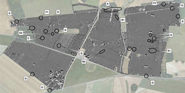
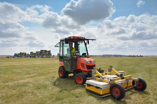
Researchers have produced digital maps of what's beneath the World Heritage Site, using ground-penetrating radar, high-resolution magnetometers and other techniques to peer deep into the soil beneath the famous stone circle.

The project produced detailed maps of 17 previously unknown ritual monuments and a huge timber building, which is thought to have been used for burial ceremonies, Birmingham University said Wednesday.

"New monuments have been revealed, as well as new types of monument that have previously never been seen by archaeologists," said Professor Vincent Gaffney, the project leader.

ap245816016672.jpg
An undated photo made available by the University of Birmingham, England, of a man driving a vehicle with surveying instruments near to Stonehenge where a hidden complex of archaeological monuments has been uncovered using hi-tech methods of scanning below the Earth's surface. AP Photo/University of Birmingham, Geert Verhoeven

The project also discovered big prehistoric pits, some of which appear to be aligned with the sun, and new information on Bronze Age, Iron Age and Roman settlements and fields, the university said.

Professor Wolfgang Neubauer of the Ludwig Boltzmann Institute for Archaeological Prospection and Virtual Archaeology in Vienna says the new maps makes it possible "for the first time, to reconstruct the development of Stonehenge and its landscape through time."

Archaeologists and others have been digging and theorizing at Stonehenge since the 1620s. The monument, 85 miles (140 kilometers) southwest of London, attracts more than 1.2 million visitors a year - including, last week, President Barack Obama.

The universities of Nottingham, Bradford and St. Andrews in the U.K., and the University of Ghent in Belgium were also involved in the project.

stonehenge-map.jpg
Some highlighted anomalies of particular interest from the first 2 years of the Stonehenge Hidden Landscapes Project. (Aerial photograph: DigitalGlobe.) A: An apparent major gap in the centre of the northern Cursus ditch. B1 and B2: The mapped route of the palisade ditch, which now seems to reach almost to the Cursus but not to link with the ditch sectionsouth of the A344. A series of small monuments and features including: C, a new 'hengiform' monument at the site of Amesbury 50, to the northwest of Stonehenge, comprising two opposed arcs of large pits surrounding a pit circle; D, a large horseshoe monument south of the Cursus; E1, clusters of anomalous features west of King Barrow ridge; E2, similar on edge of cursus/ argo intersection; F, a series of large pits in various positions across the surveyed area but with two very large pits situated at the western and eastern ends of the Cursus monument; G, a range of annular features - some related to recorded crop marks and some not. Gaffney et. al./The Stonehenge Hidden Landscapes Project
View CBS News In
CBS News App Open
Chrome Safari Continue
Be the first to know
Get browser notifications for breaking news, live events, and exclusive reporting.