Another major storm bears down on a soaked Northern California
TRACY, Calif. -- Some Northern California residents are preparing for another powerful Pacific storm by patrolling levees for signs of danger, reviewing evacuation plans and filling hundreds of sand bags.
One woman near Tracy, 80 miles east of San Francisco, said though the levees appear in good shape, residents decided take charge after the San Joaquin River started rising.
“We have a levee response team, a sand bagging team, teams to check on what walkers checking on the levees find,” said San Joaquin River Club resident Paula Martin, who is helping coordinate emergency plans for the private neighborhood of 800 homes.
Martin said the neighborhood has sirens in the clubhouse and at a church that can warn residents of impending flooding.
“Our community is pulling together like real champs,” she said, adding that volunteers have been patrolling the levees every two hours.
The area saw rain and wind Sunday afternoon but forecasters said a storm packing a bigger punch was to reach the San Francisco Bay Area overnight before moving to the Central Valley.
Meteorologists say the next few days could bring up to ten inches of rain to parts of the waterlogged state.
During recent storms, authorities up and down the state have dealt with overflowing creeks, mudslide threats in foothill areas blackened by fires, road collapses and hundreds of toppled trees in neighborhoods. At least three people have died, in Southern California.
The San Joaquin River, at a measuring station near Vernalis - about 10 miles southeast of Tracy - remained at “danger stage” Sunday, meaning it keeps approaching the tops of levees, said Tim Daly, a spokesman with San Joaquin County Office of Emergency Services.

“When the water gets that high and more water is coming, there is just too much pressure and levees can break,” Daly said. “They can be topped.”
Another area of concern is the Don Pedro reservoir, which officials said was at 98 percent capacity on Sunday. The reservoir captures water from the Tuolumne River, a key tributary of the San Joaquin.
South of San Francisco, the Anderson Reservoir near Morgan Hill was overflowing into the Anderson Dam’s spillway and was well beyond its seismic safety limits if a major quake were to hit, reports CBS San Francisco.
The storm runoff and dam water releases were clogging the San Francisco Bay with debris and also beginning to concern biologists about the delicate salt water/fresh water balance in the ecologically sensitive waters.
The San Francisco Bay Ferry service that takes thousands of commuters daily from Oakland, Vallejo, Alameda and South San Francisco has had four of its ultra-modern boats damaged by the debris in the last three weeks, causing service disruptions.
The National Weather Service has issued a Flood Watch through Monday night for the entire Bay Area.
Forecasters said rainfall amounts of 4 to 7 inches will be possible along the coastal ranges with the potential for some locations to see upwards of 10 inches.
North Bay valley locations, coastal areas in and around the San Francisco Bay Area and areas around Santa Cruz have the potential to receive 2 to 5 inches of rainfall through Monday night.
Winds will also be a factor, the weather service said, with sustained southerly winds 20 to 35 mph with gusts of 45 to 50 mph.
The storm front will linger into Tuesday, forecasters said.
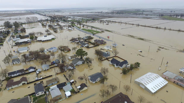
Meanwhile, water was receding in the farm community of Maxwell, about 70 miles north of Sacramento, where dozens of people sought higher ground Friday after creeks topped their banks and inundated houses. Crews used boats to rescue residents from the low-lying neighborhood.
Officials advised residents to be ready to evacuate.
“We’re telling those people to keep a bag close by and get ready to leave again,” said Colusa County Assistant Sheriff Jim Saso Saso. “If the water comes back up, it’s going to be those areas affected.”
About 60 miles east, the water level continued to fall at Oroville Dam, where a damaged spillway had raised major flood concerns and prompted the evacuation of 188,000 people last weekend.
The amount of water flowing down the spillway was increased from 55,000 cubic feet a second to 60,000 cubic feet a second Sunday afternoon in anticipation of the storm, the California Department of Water Resources said. Last week, outflows were at nearly 100,000 cubic feet a second.