Storm forecasters: "Catastrophic" damage possible in Kansas, Missouri
(CBS News) NORMAN, Okla. - Slate gray skies quickly turned black and ominous as storm clouds loomed across the Southern Plains Friday afternoon. The pace at the Storm Prediction Center in Norman, Oklahoma quickened as formations on the radar screens confirmed the approach of serious trouble.
The first tornado watch was issued in mid-afternoon and a twister already touched down in Norman late Friday afternoon.
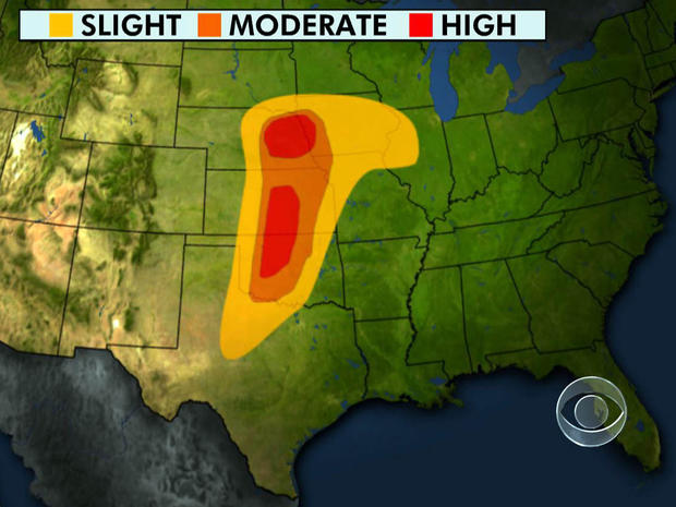
For only the second time in history, officials here put out a high-risk notice a full day in advance of what they say will be the worst of the storm, CBS News correspondent Dean Reynolds reports.
National Weather Service: High tornado risk Saturday for Kansas, Oklahoma
Storm Prediction Center
To further alert the public, several weather service stations in Kansas and Missouri will be trying out new, more urgent warning language to urge people to find shelter underground - for example, that "catastrophic damage" may be in store.
"We want to make certain that we do every effort to make sure the people who receive those, can act on those and can make themselves safe," said Mike Foster, a National Weather Service forecaster.
It has been an unusually active and deadly spring. This March was the fourth deadliest on record.
Scientists say every second of advance warning can save lives.
"There's a lot of knowledge now and we understand better and are able to provide better lead times," Foster said.
Technological breakthroughs such as dual polarization radars are a big part of it. They allow meteorologists to distinguish between merely rain in a thunderstorm and much more telling airborne debris that could only be captured in a funnel cloud.
The radars will be called into action over the next few hours as the potentially catastrophic storm system casts a shadow over the nation's midsection -- putting 5.5 million people in danger over the next 24 hours from what the weather service calls very powerful "long track tornadoes."
Officials say Oklahoma, Kansas and Nebraska are in the danger zone over the next 24 hours. But the violent storm may well fan out as far north as Wisconsin by Sunday, as far east as Louisiana.