Northeast expecting wintry weather on 1st day of spring
BOSTON -- After a mild winter, a weekend storm is bearing down on the Northeast just as residents are looking forward to Sunday's official start of spring.
Over six inches of accumulation is possible, mostly in New England and along coastal parts of the region. New York and Philadelphia should at least get a few inches, forecasters say.
"I was thinking that winter was over, but I have learned there is always a surprise around the corner," said Pete Kusinski, a 32-year-old Cambridge resident. "If it's Monday, it's really going to screw up the commute. But if it's over the weekend, it's less of a big deal."
The snow should start Sunday morning in mid-Atlantic cities like Washington, D.C, Philadelphia and New York, but higher temperatures should help mitigate snow accumulations, said Thomas Kines, a Pennsylvania-based meteorologist for AccuWeather.
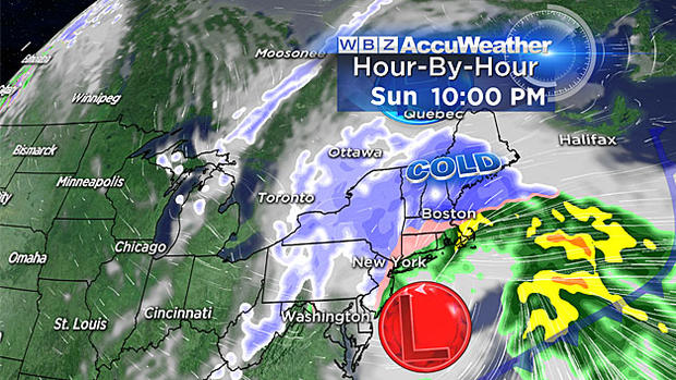
"We're most concerned with New England with this storm," Kines said. "I don't think there will be many problems in the D.C./Baltimore area. New York, New Jersey and Philadelphia is a little bit iffier."
"You are looking at the possibility of three to six inches -- a lot of variation because of that mixing," CBS New York meteorologist John Elliott said Friday. "We do have March storms. Since 1869, 27 big ones, but in the last 20 years they have been rare. We could see another rare one this weekend."
New England, in contrast, won't see the brunt of the inclement weather until Sunday night, when temperatures drop.
And the snow could stick around through Monday morning in New England, possibly creating a messy commute and prompting school cancellations, says Frank Nocera, a Massachusetts-based meteorologist for the National Weather Service.
"There's still a lot of uncertainty, still a lot of moving parts," he said. "We're two-plus days out, so the storm really hasn't formed yet."
"We are likely in for a good thumping of heavy, wet snow," CBS Boston meteorologist Terry Eliasen said. "The exact area where the heaviest snow bands set up is still a bit of a question mark, but it appears the most likely location will be somewhere near the Coast, in Eastern MA. As of right now, the City of Boston looks like it could be right in the bulls eye."
This winter has been relatively tame for the Northeast.
Washington, New York, Philadelphia and other mid-Atlantic cities have seen higher-than-average snowfall, but temperatures have been milder than usual, meaning the snow hasn't really stuck around very long, Kines said.
New York has seen about 32 inches of snowfall this winter, with about 27 inches for Philadelphia and about 22 inches for D.C., according to Kines. Most of that came during a massive, record-breaking blizzard that blanketed much of the eastern United States in January. In that storm alone, New York got nearly 27 inches and Philadelphia and D.C. each recorded about 22.
In New England, which weathered historic snowfalls last year, accumulation has been below average.
Boston saw more than 100 inches of snow last year but just 26 inches this year, according to Kines. The city averages about 40 inches per winter.
"The best thing about New England is the weather," said Edward Smith, a 25-year-old Boston resident. "You never know what's coming."
To be sure, it isn't novel for the region to see snow on the first day of spring. A few inches fell last year from Boston to Philadelphia.
"March is a very fickle month," Kines said. "This kind of stuff happens. We'll get these warm spells and then people will think spring is here and then Mother Nature says, 'Not so fast.'"