Nature up close: A Grand Canyon geology lesson
By "Sunday Morning" contributing videographer Judy Lehmberg.
I love the Grand Canyon, both personally (because of all the good memories I have of my adventures there), and as a scientist. I first saw it in the early summer of 1981 when I went on a six-week-long field trip while taking courses in geology and plant taxonomy. I am much more of a biologist than a geologist, but even I could see what an absolute geological wonder it is.
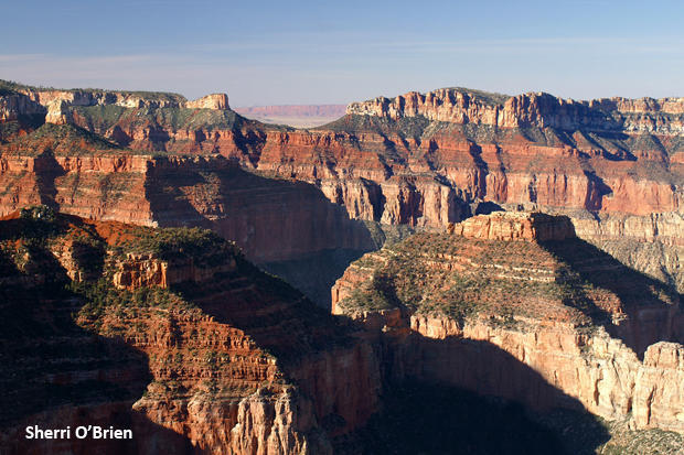
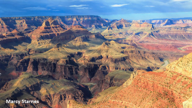
Not because of its size or its beauty – although it is big and stunningly beautiful. The thing that makes it geologically awesome is that as you walk down it, especially from the higher north side, you are literally walking through two billion years of geological history. There aren't too many places where you can do that, especially in North America.
The first time I walked down the canyon I had the flu, and I was a smoker. On the way up, breathing hard and feeling terrible, I stopped a number of times to catch my breath, and then (this was how stupid I was) smoked a cigarette. I don't look back on that part with too many fond memories, but I did have great company, and the rest of that trip was one of the most memorable learning experiences of my life.
During that walk, a good friend of mine and I made a pact: If either of us got the stupid idea to do it again, we would call the other one so they could talk them out of it. That didn't work out so well. I've been back five times, and one of those was with that same friend and a group of her high school students whom we didn't have enough energy to wear out (like the one we found in a running commercial clothes dryer after some of the other students had stuffed him inside and slammed the door).
Actually the rest of the trips were fun. I never went down sick again and had the sense to quit smoking. My husband and I started taking our own students on six-week trips around the West while they learned environmental science from him and plant taxonomy from me. To this day we are still in contact with some of those students. We never had any of them drop or make a grade lower than a C, and the majority made As and Bs. One highlight from those trips was, while we were falling asleep near the bottom of the canyon, I opened my eyes to see a spotted skunk a few feet in front of my face (no tents trekked in, to reduce weight). One low point was when I found that two students had brought their environmental science textbooks with them because they had a test when we came up. Do you know how heavy those textbooks were?
The Grand Canyon is a visual textbook of geology and ecology. I'm going to talk about the geology this week, and the ecology next week.
From a geological perspective, walking down the canyon is literally like walking through the pages of a well-illustrated geology book, one that has a couple of pages folded over and a few torn out but the rest undamaged and readable.
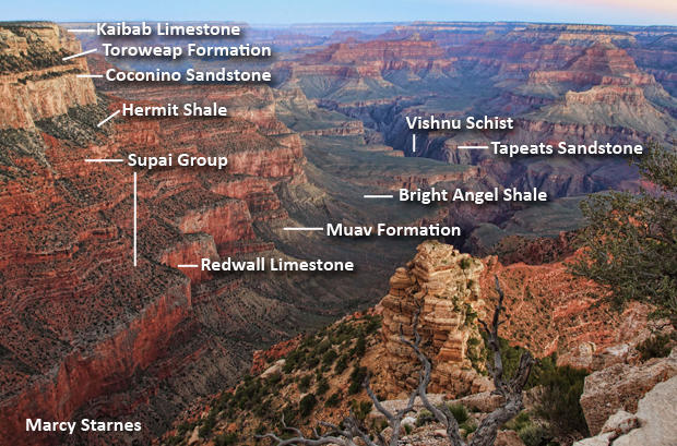
The top of the canyon is composed of a layer of limestone, the Kaibab formation. At about 270 million years old, it is the youngest rock in the canyon. The Kaibab was formed as sandy limestone was laid down in a shallow sea. Its surface is the Kaibab Plateau on the north side of the canyon.
Next comes the Toroweap Formation, composed of limestone and sandstone dumped into a warm, shallow sea as it invaded and retreated over land 273 million years ago. Below the Toroweap is cliff-forming Coconino Sandstone, dunes formed in a desert climate 275 million years ago. The Coconino is followed by Hermit Shale, a broad coastal plain of layers of iron oxide, silt and mud precipitated from freshwater streams 280 million years ago.
The following layers are the Supai Group, deposited 315 to 285 million years ago as marine and non-marine deposits of mud, silt, sand and calcareous sediments on a coastal plain very similar to the current Texas coast. Formed 340 million years ago. the Redwall Limestone is the next layer; from 400 to 800 feet thick, it is one of the most prominent layers due to its prominent red cliffs. The red color actually comes from iron in the above Supai Group and the Hermit Shale.
There is a gap in the layers between the Redwall and the Muav Limestone. There are no sediments from either the Ordovician or Silurian geological time periods. It isn't known whether those layers were deposited and then completely eroded or were never deposited at all. So, there is a time period of about 65 million years that is not represented at all. That is known as a disconformity.
At about 505 million years old the Muav Limestone is the next layer down. It is made of limestone and was deposited further off shore.
The next layer is the 515-million-year-old Bright Angel Shale, with primarily greenish mudstone originally accumulated in a shallow sea close to shore. Sand and conglomerate were deposited on a shoreline 525 million years ago to form the Tapeats Sandstone cliffs. The evidence that it was a shoreline comes from the ripple marks present in its rocks.
The Colorado River runs through the lowest visible layer, the Vishnu Schist, at over two billion years old the oldest layer in the canyon. It is composed of metamorphosed sand, mud, silt and ash deposited in a marine basin. It is currently 6,000 feet below the top of the canyon, but at one time it was 12 miles under other rock layers, before the canyon existed. The Vishnu has been exposed to volcanic activity, collision of continents, and pressurized into its current form.
The above explains the layers forming the canyon, but doesn't account for the presence of the Colorado River running through it. About 75 million years ago an area from what is now Canada to northern Mexico began to uplift and form the beginning of the Rocky Mountains as well as the Colorado Plateau, where the Grand Canyon is located. Because the area tilted slightly to the southwest, several rivers and streams consolidated to form the early Colorado River which drained into the Gulf of California. Some geologists disagree about when the canyon began forming. For years the most convincing evidence pointed to its formation starting a short six million years ago. Today some research indicates it may have started around 70 million years ago.
Whenever it began forming, the canyon exists because as the area uplifted, the river cut into the underlying layers. The timing had to be right because if the uplift occurred too quickly, the river would have changed course and flowed in another direction. But the uplift was slow enough that the river continued on its same course as it carved the canyon deeper and deeper to its current depth of just under 6,100 feet.
Sadly, today the river no longer reaches the Gulf of California, as Hoover Dam, Glen Canyon Dam and more than a dozen other dams – which provide water and electricity for cities such as Phoenix, Tucson, and Las Vegas, as well as for farming – have dewatered it. One aspect often overlooked by the pro-dam crowd is that these dams actually cause more water loss than if they didn't exist because they increase the surface area of the water, and therefore more water evaporates.
Due to climate change the water levels in the Colorado have dropped over the last few decades. Today a giant "bathtub ring" in Lake Powell is an obvious sign of its former water levels.
Next week: The ecology of the Grand Canyon.
Judy Lehmberg is a former college biology teacher who now shoots nature videos.
For more info:
- Grand Canyon National Park (NPS)
- Nature up close: The Grand Canyon ("Sunday Morning," 7/10/17)
See also:
- Judy Lehmberg (Official site)
- Judy Lehmberg's YouTube Channel
To watch extended "Sunday Morning" Nature videos click here!
Recently from "Nature Up Close: