Rover's first high-res color frames provide stunning view of Mars
CBS News
Portions of the Curiosity rover's first high-resolution color panorama were unveiled Saturday, providing stunning vistas of the mountain-like walls of Gale Crater in the hazy distance, the gravel-strewn floor of the crater near the lander and areas where topsoil was blasted away by the lander's sky crane rockets.
 |
| A closeup view of a section of the panorama looking north toward the rim of Gale Crater. This section of the panorama is in the upper left of the incomplete mosaic. (Credit: NASA) |
Mount Sharp, a three-mile-high mound of layered terrain that Curiosity eventually will attempt to scale, has not yet been imaged by the high-resolution mast camera.
Curiosity is in the process of downlinking the pictures making up the mosaic and as a result, the panorama is not yet complete. Areas where pictures have not yet come in are blacked out. A sampling of pictures that have been received so far is presented below. In the absence of any weekend news briefings, a NASA description of the panorama is included.
Source: NASA
NASA's Curiosity rover has shipped back to Earth high-resolution color images of its surroundings on Mars, sharpening our views of an intriguing channel, layered buttes and a layer of cobbles and pebbles embedded in a finer matrix of material. The images show a landscape closely resembling portions of the southwestern United States, adding to the impression gained from the lower-resolution thumbnail images released earlier this week.
The 79 images that went into the large mosaics were taken on Aug. 8, 2012 PDT (Aug. 9, EDT) by Curiosity's 34-millimeter Mastcam. The black areas indicate high-resolution images not yet returned by the rover.
The full-resolution images are available at: http://www.nasa.gov/msl and http://mars.jpl.nasa.gov/msl/multimedia/images/ .
Curiosity sent lower-resolution versions of these images earlier in the week. The latest versions, sent while Curiosity was undergoing a software "brain transplant" and pausing in its acquisition of new science data, are 1,200 by 1,200 pixels.
In one version of the large mosaic, the colors portrayed are unmodified from those returned by the camera. The view is what a cell phone or camcorder would record, since the Mastcam takes color pictures in the exact same manner that consumer cameras acquire color images. The second version shows the colors modified as if the scene were transported to Earth and illuminated by terrestrial sunlight. This processing, called "white balancing," is useful for scientists to be able to recognize and distinguish rocks by their color in more familiar lighting.
Smaller mosaics of some of the areas most interesting to science team members are also available. One shows a section on the crater wall north of the landing site, where a network of valleys believed to have formed by water erosion enters Gale Crater from the outside. This is the first view scientists have had of a fluvial system -- one relating to a river or stream - from the surface of Mars.
A second section of the mosaic looks south of the landing site, towards Mount Sharp, a peak that is about 3.4 miles (5.5 kilometers) high and taller than Mt. Whitney in California. This provides an overview of the eventual geologic targets Curiosity will explore in the next two years. Close by is a rock-strewn, gravelly surface. Farther away is a dark dune field, and beyond that lie the layered buttes and mesas of the sedimentary rock of Mount Sharp.
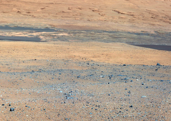
Another section of the mosaic shows an area excavated by the blast of the Mars Science Laboratory's descent stage rockets. With the loose debris blasted away by the rockets, details of the underlying materials are clearly seen. Of particular note is a well-defined, topmost layer that contains fragments of rock embedded in a matrix of finer material.
Curiosity continues to be very healthy, with all instruments and engineering subsystems operating as planned. There are no science or instrument activities planned on Sol 5. Last night, the new flight software, which is optimized for surface operations, was tested for the first time and successfully executed all planned Sol 5 rover activities. The test demonstrated that the new software is ready to support the upcoming surface operations mission phase.
After an afternoon nap, Curiosity then returned to operating on its previous flight software, as planned. The rover's primary main computer will be permanently transitioned to the new flight software on Aug. 13.
 |
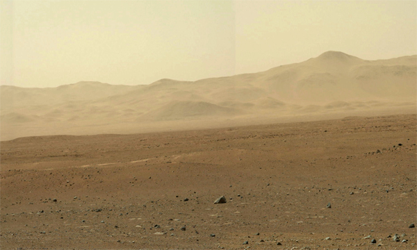
| Part of a 360-degree high-resolution color panorama shot by the Curiosity rover late last week. Individual frames making up the mosaic are in the process of being relayed to Earth. In the above view, areas in black represent zones where photos have not yet been sent back to Earth. (Credit: NASA) |
 |
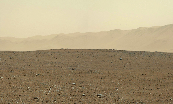
| Another view closer to the flanks of Mount Sharp, out of view to the right. (Credit: NASA) |
 |
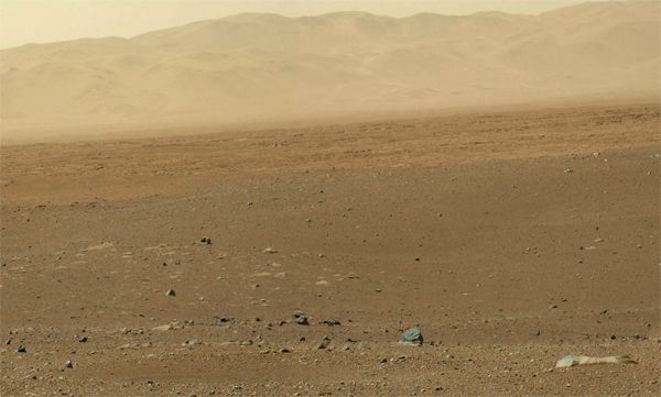
| Looking to the far side of the unseen Mount Sharp, the crater floor stands in sharp relief as a rise in the foreground gives way to the crater wall in the distance. (Credit: NASA) |
 |
| In this "white balanced" view, the base of Mount Sharp stands out as it rises from dark dune fields closer to Curiosity. Engineers believe the rover eventually will be able to make its way across the dunes and up the side of the mound, moving across beds that hold clues about the history of the red planet's evolution. (Credit: NASA) |
 |
| In this closeup view of the ground near the lander, NASA has highlighted an area where the exhaust plumes from Curiosity's sky crane rockets blasted topsoil away, revealing underlying rock. (Credit: NASA) |