NASA
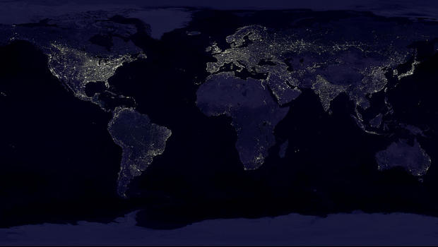
This NASA image from a composite assembled from data acquired by the Suomi NPP satellite in April and October 2012 shows the city lights of earth at night. The new data was mapped over existing Blue Marble imagery of Earth to provide a realistic view of the planet. NASA has released new composite images of earth taken by the National Oceanic and Atmospheric Administration's Suomi National Polar-orbiting Partnership satellite. A new sensor aboard the NPP satellite is enabling scientists to observe Earth's atmosphere and surface during nighttime hours, in greater detail than ever before.
NASA
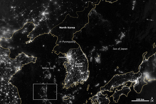
In this image from Sept. 24, 2012, provided by NASA, the Korean Peninsula is seen at night from a composite assembled from data acquired by the Suomi NPP satellite. The image was made possible by the new satellite's "day-night band" of the Visible Infrared Imaging Radiometer Suite (VIIRS), which detects light in a range of wavelengths from green to near-infrared and uses filtering techniques to observe dim signals such as city lights, gas flares, auroras, wildfires, and reflected moonlight. City lights at night are a fairly reliable indicator of where people live. But this isn't always the case, and the Korean Peninsula shows why. As of July 2012, South Korea's population was estimated at roughly 49 million people, and North Korea's population was estimated at about half that number. But where South Korea is gleaming with city lights, North Korea has hardly any lights at all, just a faint glimmer around Pyongyang. The wide-area image shows the Korean Peninsula, parts of China and Japan, the Yellow Sea, and the Sea of Japan. The white inset box encloses an area showing ship lights in the Yellow Sea. Many of the ships form a line, as if assembling along a watery border.
NASA
In this image provided by NASA, the United States of America is seen at night from a composite assembled from data acquired by the Suomi NPP satellite in April and October 2012.
NASA
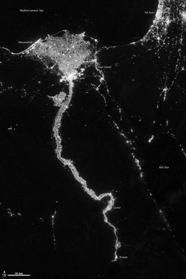
In this image from Oct. 13, 2012 provided by NASA, the Nile River valley and delta is seen at night from a composite assembled from data acquired by the Suomi NPP satellite. The Nile River Valley and Delta comprise less than 5 percent of Egypt's land area, but provide a home to roughly 97 percent of the country's population. Nothing makes the location of human population clearer than the lights illuminating the valley and delta at night. The city lights resemble a giant calla lily, just one with a kink in its stem near the city of Luxor. Some of the brightest lights occur around Cairo, but lights are abundant along the length of the river. Bright city lights also occur along the Suez Canal and around Tel Aviv. Away from the lights, however, land and water appear uniformly black. This image was acquired near the time of the new Moon, and little moonlight was available to brighten land and water surfaces.
NASA
This NASA image from a composite assembled from data acquired by the Suomi NPP satellite in April and October 2012 shows the earth's city lights at night. The new data was mapped over existing Blue Marble imagery of Earth to provide a realistic view of the planet.
NASA
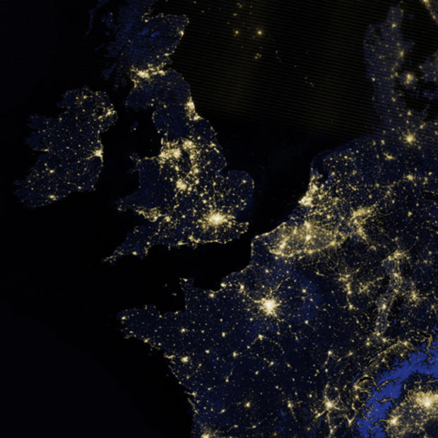
This image provided by NASA from a composite assembled from data acquired by the Suomi NPP satellite shows Great Britain, Ireland, and part of northwestern Europe, including France, Belgium and the Netherlands, as they appeared on the night of March 27, 2012.
NASA
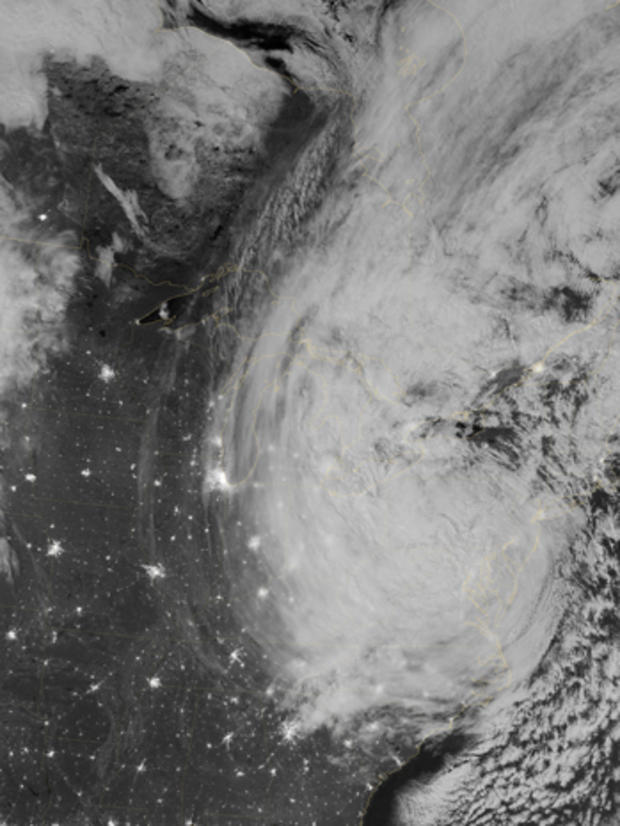
This image provided by NASA shows the eastern seaboard of the United States of America at night from a composite assembled from data acquired by the Suomi NPP satellite as Hurricane Sandy came ashore on Oct. 30, 2012.
AP Photo/Ben Margot
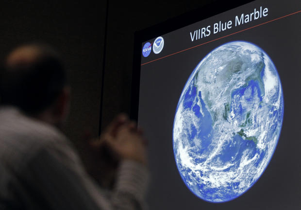
A man looks at a view of Earth from space during a media conference, Dec. 5, 2012, at the American Geophysical Union meeting in San Francisco.
AP Photo/Ben Margot
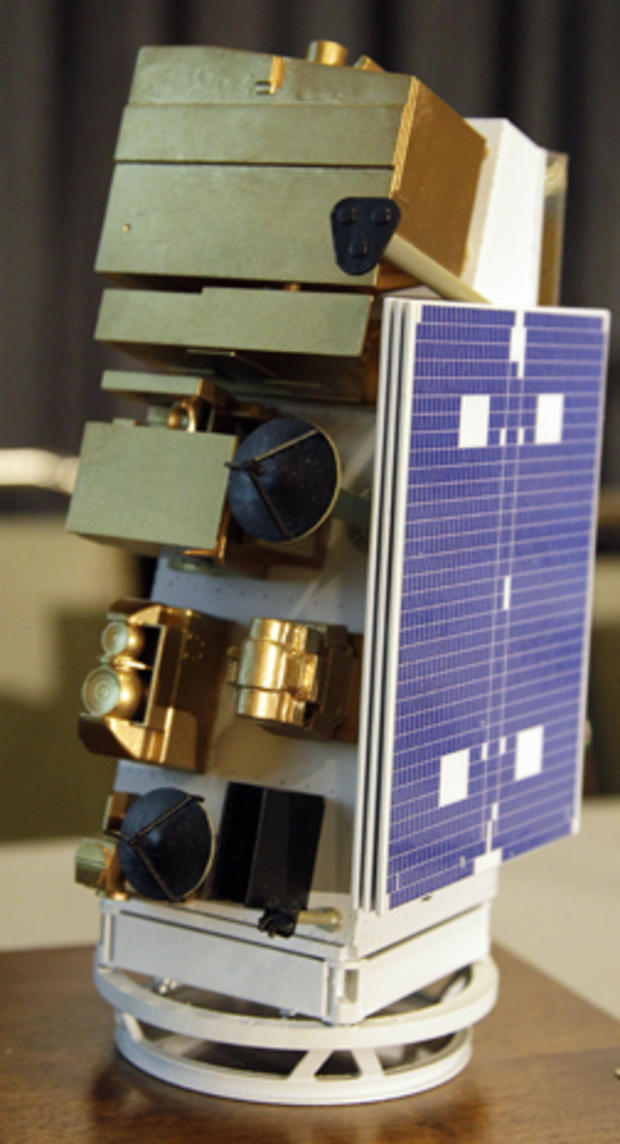
A 1/20 scale model of the National Aeronautics and Space Administration-National Oceanic and Atmospheric Administration's Suomi National Polar-orbiting Partnership satellite, which was launched last year, is seen Dec. 5, 2012, at the American Geophysical Union meeting in San Francisco.
AP Photo/Ben Margot
James Gleason, Suomi National Polar-orbiting Partnership Project scientist at the National Aeronautics and Space Administration's Goddard Space Flight Center, speaks during a media conference, Dec. 5, 2012, at the American Geophysical Union meeting in San Francisco.