Weather Whiplash: From record-shattering heat to cold and snow
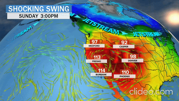
The best word to describe the weather across the West is: "Bonkers." In a matter of days, the region will experience some of the hottest weather ever recorded in California, a strong downslope wind event igniting fire concerns, a 70-degree swing in temperatures in Denver and an extremely early snow storm walloping Colorado, New Mexico and Wyoming.
If that's not bizarre enough, partly powering the chaotic pattern are two back-to-back typhoons thousands of miles away in Japan and North Korea. Throw in some human-caused climate change, which is playing a role, and the weather does not get more extreme.
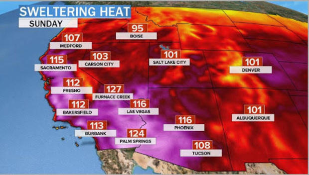
It has already been the hottest summer on record for much of the Southwest and parts of California. But from Friday to Monday, more than 150 record-high temperatures are forecasted.
In Los Angeles, the mercury may soar to a dangerous 110 degrees Fahrenheit on Sunday, eclipsing the daily record by 8 degrees. The all-time record is 113 degrees, set in September 2010.
The temperature in Phoenix is expected to top out between 110 and 115 degrees for the next four days. That would be a total of 54 days of 110 degrees or higher this summer, breaking the previous record of 33 days in 2011.
By the weekend, the core of the heatwave will shift westward over California and valley cities like Bakersfield, Fresno and Sacramento will see highs between 110 and 115. Even Oakland will reach 100 degrees on Sunday.
The heat will begin to fade on Tuesday as a strong cold front pushes south for most of the west, with the exception of California.
Such temperatures pose a major threat to health, given that many people will be out for Labor Day weekend, risking both heat exposure and exposure to COVID-19. Fire is also a risk.
Three of the top 4 biggest wildfires on record in California history are burning. The heat will further dry out the brush and with more people outdoors, officials are concerned about an increase in ignitions.
As a wicked early season cold front drops South into the Great Basin, it will send strong winds across the Sierra-Nevada. Despite fighting historic fires during August, the state has so far escaped widespread wind. This will change on Tuesday as a gusty downslope wind event develops.These type of wind events are a big reason why out of control fires burn in California during fall.
According to an April study led by Stanford University, days with extreme fire weather during autumn have doubled since the 1980s due to a long-term warming of 2 degrees Fahrenheit and 30% less autumn rain. The study concludes that human-caused climate change will continue to amplify the extreme fire weather.
As the holiday weekend comes to a close, the record breaking ridge of high pressure in the west will be demolished by a fierce jet stream diving far to the south. In Denver, the high Sunday will be near 100, but by Wednesday morning, temperatures will plummet into the 20s, courtesy of Arctic air from the high reaches of Canada.
Within about 18 hours — from Monday afternoon into Tuesday morning — the temperature will drop off a cliff, from 95 degrees to 35 degrees; that's a 60-degree temperature swing in less than 24 hours. Dramatic for sure, and possibly in contention for a record. However, on one day last October, the temperature dropped from 83 to 13 degrees in Denver — a 70-degree swing — but over 30 hours.
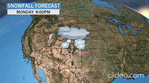
The drama does not stop there. As the jet stream settles into the deep Southwest, a strong storm will propel the air into the front range of the Rockies, squeezing out moisture into a near freezing air mass. Snow will fly — and perhaps a lot — if you believe the computer models advertising well over a foot in the mountains and possibly several inches in Boulder and potentially even in Denver.
There are two good explanations for such extreme weather.
On Wednesday, Typhoon Maysak slammed into South Korea and Japan, and this weekend Super Typhoon Haishen will follow a similar trajectory. While over 6,000 miles away, these two storms will produce ripple effects, literally, by manipulating an already wavy jet stream. In short, the outflow of copious heat energy from the typhoons in Asia will further magnify the jet stream downstream, driving frigid air south into the Rockies.
The effect of the typhoons is just one part of an interconnected system, which consists both of natural forcing and human forcing too, due to the extra heat building up in the oceans and atmosphere from excess greenhouse gas emissions.
Each of these extreme weather phenomena, from the typhoons to the heatwave, carry with them this extra human heat energy. The simplest explanation is that extra energy is amplifying an already extreme pattern, resulting in an even more extreme weather pattern that we are about to experience.
Delving slightly deeper, science has found a connection between a rapidly warming Arctic, which is warming at 3 times the average global rate, and weather patterns south of the Arctic in the mid-latitudes, through modulation of the jet stream. Although the extent of the connection is debated, multiple studies by well-respected climate scientists like Jennifer Francis, Michael Mann and Zach Labe, have shown what happens in the Arctic does not stay in the Arctic.
So as we head into Labor Day weekend, in short order, Mother Nature is vividly illustrating that every action indeed has an opposite reaction and that for better or worse, everything is connected.